21223+2906 COU 532
21h 22m 19.57s +29° 06' 23.1" P.A. 45.00 sep 0.4 mag 9.50,9.50 Sp G0
| Coord 2000 |
21223+2906 |
|
Discov num |
COU 532 |
|
Comp |
|
|
Coord arcsec 2000 |
21 22 19.57 +29 06 23.1 |
|
| Date first |
1970 |
|
Date last |
2016 |
|
Obs |
21 |
|
| Pa first |
78 |
|
Pa last |
45 |
|
P.A. Now (θ) |
45° |
|
| Sep first |
0.1 |
|
Sep last |
0.387 |
|
Sep. Now (ρ) |
0.387" |
|
| Mag pri |
9.50 |
|
Mag sec |
9.50 |
|
delta mag (ΔM) |
0 |
|
Spectral class |
G0 (yellow) |
|
| Pri motion ra |
+030 |
|
Sec motion ra |
|
|
| Pri motion dec |
+015 |
|
Sec motion dec |
|
|
| Notes |
O
(Orbital solution) |
|
This double is physical.
OTHER CATALOGS AND DESIGNATIONS
| Constellation |
Cygnus |
|
Tycho2 |
2199-00128-1 |
|
Gaia DR2 |
1848618245631059456 |
|
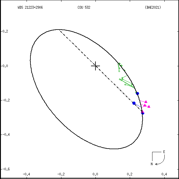
ORBITAL ELEMENTS
| Period (P) | 556.1y | ± 91 |
Periastron (T) | 1959.3y | ± 2.5 |
Semi-major axis (a) | 0.494a | ± 0.052 |
| Eccentricity (e) | 0.5669 | ± 0.033 |
Inclination (i) | 119.3° | ± 1.4 |
Longitude of periastron (ω) | 258.1° | ± 8.4 |
| Node (Ω) | 45.4° | ± 1 |
Notes | | |
Reference | BAE2021 | |
| Equinox | | |
Last observation | | |
Grade | 4 | (1=Definitive, 9=Indet.) |
| label |
theta |
rho |
| 2000 |
53.5 |
0.311 |
| 2001 |
52.9 |
0.317 |
| 2002 |
52.3 |
0.322 |
| 2003 |
51.7 |
0.327 |
| 2004 |
51.1 |
0.331 |
| 2005 |
50.5 |
0.336 |
| 2006 |
50.0 |
0.341 |
| 2007 |
49.4 |
0.345 |
| 2008 |
48.9 |
0.350 |
| 2009 |
48.4 |
0.354 |
| 2010 |
47.9 |
0.359 |
| 2011 |
47.4 |
0.363 |
| 2012 |
46.9 |
0.367 |
| 2013 |
46.4 |
0.371 |
| 2014 |
46.0 |
0.375 |
| 2015 |
45.5 |
0.379 |
| 2016 |
45.1 |
0.382 |
| 2017 |
44.7 |
0.386 |
| 2018 |
44.2 |
0.390 |
| 2019 |
43.8 |
0.393 |
| 2020 |
43.4 |
0.396 |
| 2021 |
43.0 |
0.400 |
| 2022 |
42.6 |
0.403 |
| 2023 |
42.2 |
0.406 |
| 2024 |
41.8 |
0.409 |
| 2025 |
41.5 |
0.412 |
| 2026 |
41.1 |
0.415 |
| 2027 |
40.7 |
0.418 |
| 2028 |
40.4 |
0.421 |
| 2029 |
40.0 |
0.424 |
| 2030 |
39.7 |
0.427 |
|
|
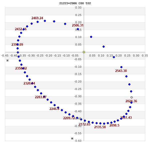
Note: Theta is PA, Rho is Sep. For yearly orbits, data refer to Jan 1st.
|
|
|
|
|
|
|
|
Measures: green=micrometric, blue=interferometric, purple=photographic |
|
WDS 21223+2906 COU 532 : NOTES
No records found.
REFERENCES
| refcode |
metd |
author |
reference |
| BAE2021 |
orb j |
Baidin, A.E. & Krechet, V.G. |
2021AstBu..76...84B |
| BAE2021 |
|
Astrophys. Bull. 76, 84, 2021 |
|
DISCOVERER
| idgroup |
discov |
author |
| 1 |
COU |
Couteau, P. |
WDS HISTORIC DATA
| coord_2000 |
discov_num |
comp |
epoch |
obs |
pa |
sep |
mag_pri |
mag_sec |
spectr |
notes |
coord_arcsec_2000 |
| 21223+2906 |
COU 532 |
|
2002 |
16 |
54 |
0.4 |
9.50 |
9.50 |
G0 |
|
212219.57+290623.1 |
| 21223+2906 |
COU 532 |
|
2006 |
17 |
53 |
0.4 |
9.50 |
9.50 |
G0 |
|
212219.57+290623.1 |
| 21223+2906 |
COU 532 |
|
2007 |
18 |
46 |
0.4 |
9.50 |
9.50 |
G0 |
|
212219.57+290623.1 |
| 21223+2906 |
COU 532 |
|
2009 |
19 |
46 |
0.3 |
9.50 |
9.50 |
G0 |
|
212219.57+290623.1 |
| 21223+2906 |
COU 532 |
|
2016 |
20 |
45 |
0.4 |
9.50 |
9.50 |
G0 |
|
212219.57+290623.1 |
If you need more information about this double, apply for a
data request form to the WDS.
WDS 21223+2906 COU 532 : VISUAL OBSERVATIONS REPORTS
No records found.
WDS 21223+2906 COU 532 : MEASURES
No records found.
WDS 21223+2906 : VIRTUAL EYEPIECE
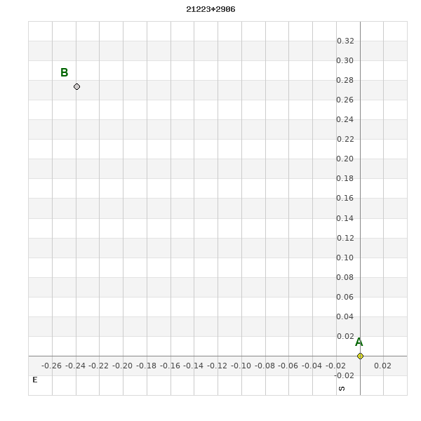
Click on the map to see the double of your interest.
Pass over with the mouse cursor to display the catalog designation.
|
|
WDS 21223+2906 : ALADIN DSS IMAGE @ 21h 22m 19.57s +29° 06' 23.1"
WDS 21223+2906 COU 532 : NEIGHBORHOODS
|
|
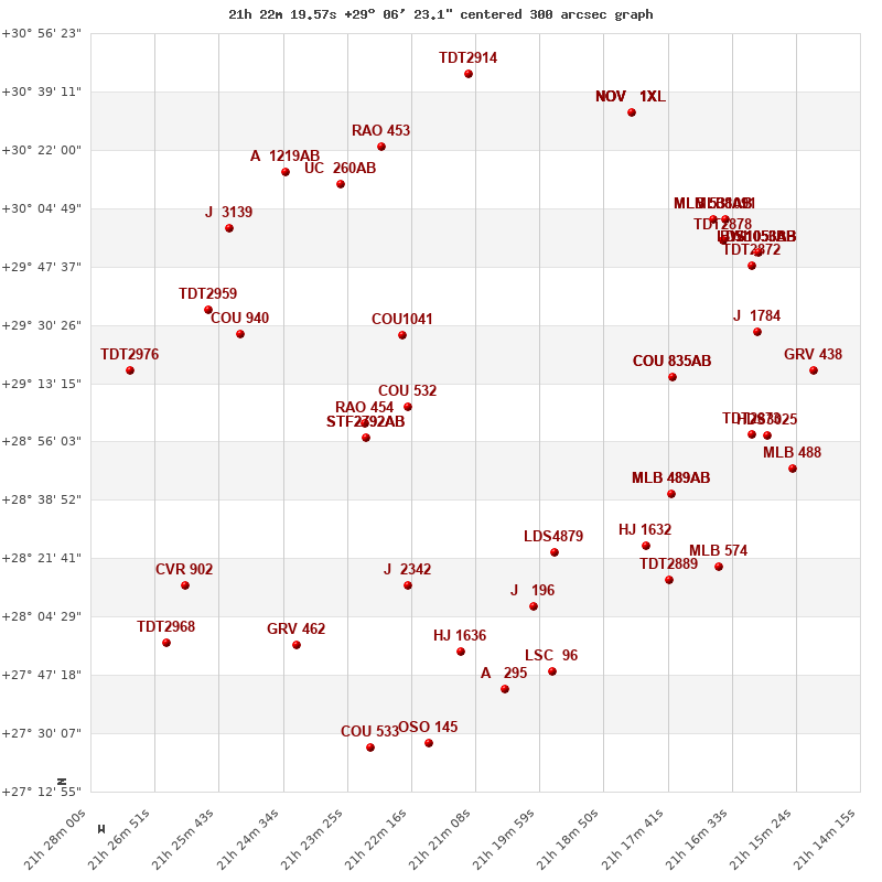
Click on the map to see the double of your interest.
Pass over with the mouse cursor to display the catalog designation.
|
| Show |
name |
coord_2000 |
discov# |
comp |
pa |
sep |
dist(') |
| Show |
|
21223+2906 |
COU 532 |
|
45 |
0.4 |
|
| Show |
|
21231+2902 |
RAO 454 |
|
9 |
0.4 |
12 |
| Show |
|
21230+2858 |
STF2792 |
AB |
331 |
7.4 |
14 |
| Show |
|
21230+2858 |
STF2792 |
AC |
161 |
22.8 |
14 |
| Show |
|
21224+2927 |
COU1041 |
|
90 |
1.3 |
22 |
| Show |
|
21253+2928 |
COU 940 |
|
263 |
0.3 |
45 |
| Show |
|
21226+2814 |
J 2342 |
|
214 |
6.1 |
53 |
| Show |
|
21259+2935 |
TDT2959 |
|
99 |
0.5 |
55 |
| Show |
|
21197+2823 |
LDS4879 |
|
88 |
258.8 |
55 |
| Show |
|
21176+2915 |
COU 835 |
AB |
238 |
0.4 |
63 |
| Show |
|
21176+2915 |
COU 835 |
AC |
247 |
12.3 |
63 |
| Show |
|
21201+2809 |
J 196 |
|
254 |
3.4 |
66 |
| Show |
|
21273+2917 |
TDT2976 |
|
275 |
0.6 |
66 |
| Show |
|
21176+2841 |
MLB 489 |
AB |
205 |
5.0 |
67 |
| Show |
|
21176+2841 |
MLB 489 |
AC |
284 |
11.0 |
67 |
| Show |
|
21256+2957 |
J 3139 |
|
331 |
6.7 |
68 |
| Show |
|
21235+3012 |
UC 260 |
AB |
243 |
33.4 |
68 |
| Show |
|
21181+2825 |
HJ 1632 |
|
44 |
8.2 |
70 |
| Show |
|
21214+2755 |
HJ 1636 |
|
185 |
7.4 |
74 |
| Show |
|
21263+2814 |
CVR 902 |
|
340 |
16.2 |
75 |
| Show |
|
21245+3015 |
A 1219 |
AB |
312 |
1.5 |
75 |
| Show |
|
21243+2756 |
GRV 462 |
|
65 |
31.1 |
75 |
| Show |
|
21228+3026 |
RAO 453 |
|
291 |
0.3 |
77 |
| Show |
|
21177+2815 |
TDT2889 |
|
45 |
0.5 |
80 |
| Show |
|
21162+2858 |
TDT2873 |
|
277 |
0.8 |
81 |
| Show |
|
21159+2858 |
HDS3025 |
|
46 |
0.2 |
85 |
| Show |
|
21162+2928 |
J 1784 |
|
338 |
5.0 |
85 |
| Show |
|
21198+2748 |
LSC 96 |
|
299 |
0.5 |
86 |
| Show |
|
21206+2743 |
A 295 |
|
253 |
0.3 |
87 |
| Show |
|
21167+2819 |
MLB 574 |
|
334 |
7.7 |
87 |
| Show |
|
21167+2955 |
TDT2878 |
|
10 |
0.6 |
89 |
| Show |
|
21266+2757 |
TDT2968 |
|
10 |
0.6 |
90 |
| Show |
|
21169+3001 |
MLB 538 |
AB |
310 |
3.2 |
90 |
| Show |
|
21169+3001 |
DAM 227 |
AC |
26 |
8.2 |
90 |
| Show |
|
21162+2948 |
TDT2872 |
|
163 |
0.7 |
91 |
| Show |
|
21153+2848 |
MLB 488 |
|
306 |
11.4 |
93 |
| Show |
|
21167+3001 |
MLB1091 |
|
170 |
10.4 |
93 |
| Show |
|
21161+2951 |
LDS1053 |
AB |
259 |
26.0 |
94 |
| Show |
|
21161+2951 |
BWL 56 |
Aa,Ab |
163 |
0.1 |
94 |
| Show |
|
21161+2951 |
BWL 56 |
AC |
77 |
3.4 |
94 |
| Show |
|
21161+2951 |
BWL 56 |
AD |
200 |
2.6 |
94 |
| Show |
|
21161+2951 |
BWL 56 |
AE |
226 |
4.4 |
94 |
| Show |
|
21161+2951 |
BWL 56 |
BF |
233 |
3.5 |
94 |
| Show |
|
21150+2917 |
GRV 438 |
|
8 |
15.2 |
96 |
| Show |
|
21212+3044 |
TDT2914 |
|
17 |
2.0 |
99 |
| Show |
|
21220+2727 |
OSO 145 |
|
342 |
10.3 |
100 |
| Show |
|
21230+2726 |
COU 533 |
|
289 |
0.7 |
101 |
| Show |
|
21182+3035 |
NOV 1 |
XL |
89 |
32.2 |
101 |
| Show |
|
21182+3035 |
NOV 1 |
XQ |
134 |
29.2 |
101 |
| Show |
|
21182+3035 |
NOV 1 |
XY |
206 |
14.1 |
101 |
| Show |
|
21182+3035 |
NOV 1 |
XZ |
57 |
18.3 |
101 |
|
|
WDS 21223+2906 : COMPONENTS
21223+2906 A
| Componente originario normalizzato |
AB |
|
Coord arcsec 2000 |
212219.57+290623.1 |
|
Mag |
9.5 |
|
Spectral class |
G0 (yellow) |
|
| PmRA |
30.00 |
|
PmDE |
15.0 |
|
Tycho2 |
2199-00128-1 |
|
DM |
BD+28 4067 |
|
| Tycho2 |
2199-00128-1 |
|
Pflag |
|
|
RAmdeg |
320.58158540 |
|
DEmdeg |
29.10643927 |
|
| PmRA |
36.0 |
|
PmDE |
23.1 |
|
E RAmdeg |
11 |
|
E DEmdeg |
12 |
|
| E pmRA |
1.2 |
|
E pmDE |
1.2 |
|
EpRAm |
1990.18 |
|
EpDEm |
1989.81 |
|
| Num |
9 |
|
Q RAmdeg |
0.8 |
|
Q DEmdeg |
0.9 |
|
Q pmRA |
0.9 |
|
| Q pmDE |
0.9 |
|
BTmag |
9.875 |
|
E BTmag |
0.024 |
|
VTmag |
9.268 |
|
| E VTmag |
0.018 |
|
Prox |
999 |
|
TYC |
T |
|
HIP |
|
|
| CCDM |
|
|
RAdeg |
320.58148972 |
|
DEdeg |
29.10638583 |
|
EpRA 1990 |
1.66 |
|
| EpDE 1990 |
1.62 |
|
E RAdeg |
11.2 |
|
E DEdeg |
12.3 |
|
Posflg |
|
|
| Corr |
0.0 |
|
| Ccdm |
21223+2906 |
|
RComp |
|
|
Comp |
A |
|
Note1 |
|
|
| Note2 |
|
|
Discov num |
|
|
DRAs |
1.48 |
|
DDEs |
23.1 |
|
| R dRAs |
10 |
|
Year |
|
|
Theta |
|
|
Rho |
|
|
| Obs |
2 |
|
Vmag |
9.5 |
|
Sp |
G0 |
|
PmNote |
* |
|
| PmRA |
24 |
|
PmDE |
18 |
|
Dm number |
+28 4067 |
|
Cat1 |
BD |
|
| Name2 |
+28 2460 |
|
Cat2 |
AGK2/3 |
|
HD |
|
|
M HD |
|
|
| ADS BDS |
|
|
M ADS BDS |
|
|
N IDS |
|
|
IDS |
21180N2841A |
|
| HIC |
|
|
21223+2906 B
| Componente originario normalizzato |
AB |
|
Coord arcsec 2000 |
212219.59+290623.4 |
|
Mag |
9.5 |
|
Calc coord |
yes |
|
| Ccdm |
21223+2906 |
|
RComp |
|
|
Comp |
B |
|
Note1 |
|
|
| Note2 |
|
|
Discov num |
COU 532 |
|
DRAs |
|
|
DDEs |
|
|
| R dRAs |
|
|
Year |
1970 |
|
Theta |
81 |
|
Rho |
0.2 |
|
| Obs |
1 |
|
Vmag |
9.5 |
|
Sp |
|
|
PmNote |
|
|
| PmRA |
|
|
PmDE |
|
|
Dm number |
|
|
Cat1 |
|
|
| Name2 |
|
|
Cat2 |
|
|
HD |
|
|
M HD |
|
|
| ADS BDS |
|
|
M ADS BDS |
|
|
N IDS |
|
|
IDS |
21180N2841B |
|
| HIC |
|
|