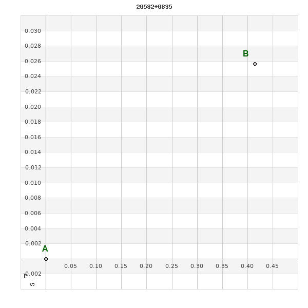
20582+0835 TDT 2664
20h 58m 10.20s +08° 35' 20.8" P.A. 274.00 sep 0.4 mag 10.86,10.95
| Coord 2000 |
20582+0835 |
|
Discov num |
TDT2664 |
|
Comp |
|
|
Coord arcsec 2000 |
20 58 10.20 +08 35 20.8 |
|
| Date first |
1991 |
|
Date last |
1991 |
|
Obs |
1 |
|
| Pa first |
274 |
|
Pa last |
273.5 |
|
P.A. Now (θ) |
273.5° |
|
| Sep first |
0.4 |
|
Sep last |
0.42 |
|
Sep. Now (ρ) |
0.42" |
|
| Mag pri |
10.86 |
|
Mag sec |
10.95 |
|
delta mag (ΔM) |
0.09 |
|
Spectral class |
|
|
| Pri motion ra |
-023 |
|
Sec motion ra |
-023 |
|
| Pri motion dec |
-039 |
|
Sec motion dec |
-039 |
|
| Notes |
|
|
Nature of this double is uncertain.
OTHER CATALOGS AND DESIGNATIONS
| Constellation |
Delphinus |
|
Tycho2 |
1103-00007-1 |
|
Gaia DR2 |
1738175983407230080 |
|
WDS 20582+0835 TDT 2664 : NOTES
No records found.
REFERENCES
No records found.
WDS HISTORIC DATA
| coord_2000 |
discov_num |
comp |
epoch |
obs |
pa |
sep |
mag_pri |
mag_sec |
spectr |
notes |
coord_arcsec_2000 |
| 20582+0835 |
TDT2664 |
|
1991 |
1 |
274 |
0.4 |
10.86 |
10.95 |
|
|
205810.20+083520.8 |
If you need more information about this double, apply for a
data request form to the WDS.
WDS 20582+0835 TDT 2664 : VISUAL OBSERVATIONS REPORTS
No records found.
WDS 20582+0835 TDT 2664 : MEASURES
No records found.
WDS 20582+0835 : VIRTUAL EYEPIECE
Click on the map to see the double of your interest.
Pass over with the mouse cursor to display the catalog designation.
|
|
WDS 20582+0835 : ALADIN DSS IMAGE @ 20h 58m 10.20s +08° 35' 20.8"
WDS 20582+0835 TDT 2664 : NEIGHBORHOODS
|
|
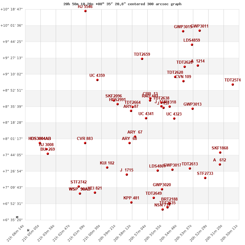
Click on the map to see the double of your interest.
Pass over with the mouse cursor to display the catalog designation.
|
| Show |
name |
coord_2000 |
discov# |
comp |
pa |
sep |
dist(') |
| Show |
|
20582+0835 |
TDT2664 |
|
274 |
0.4 |
|
| Show |
|
20583+0831 |
ARY 87 |
|
215 |
62.2 |
5 |
| Show |
|
20593+0838 |
HDS2991 |
|
167 |
0.1 |
17 |
| Show |
|
20572+0823 |
UC 4341 |
|
344 |
63.1 |
20 |
| Show |
|
20569+0842 |
RAO 443 |
|
297 |
0.2 |
21 |
| Show |
|
20568+0844 |
CRB 13 |
|
177 |
131.6 |
22 |
| Show |
|
20596+0842 |
SKF2096 |
|
109 |
9.2 |
22 |
| Show |
|
20580+0804 |
ARY 67 |
|
1 |
152.9 |
32 |
| Show |
|
20560+0837 |
J 1346 |
|
327 |
2.4 |
33 |
| Show |
|
20560+0840 |
TDT2638 |
|
97 |
2.2 |
33 |
| Show |
|
20559+0835 |
J 157 |
|
171 |
3.8 |
35 |
| Show |
|
20584+0757 |
ARY 68 |
|
339 |
112.4 |
39 |
| Show |
|
20554+0836 |
J 1318 |
|
139 |
0.9 |
42 |
| Show |
|
20550+0823 |
UC 4323 |
|
103 |
35.6 |
49 |
| Show |
|
21008+0904 |
UC 4359 |
|
85 |
33.3 |
49 |
| Show |
|
20575+0926 |
TDT2659 |
|
282 |
0.5 |
52 |
| Show |
|
20550+0907 |
TDT2628 |
|
64 |
0.5 |
57 |
| Show |
|
20544+0902 |
CVN 109 |
|
283 |
0.5 |
63 |
| Show |
|
21018+0757 |
CVR 883 |
|
128 |
28.3 |
66 |
| Show |
|
20537+0833 |
GWP3013 |
|
15 |
7.0 |
68 |
| Show |
|
21001+0731 |
KUI 102 |
|
191 |
0.2 |
71 |
| Show |
|
20543+0918 |
TDT2620 |
|
68 |
0.5 |
72 |
| Show |
|
20586+0723 |
J 1715 |
|
125 |
5.2 |
73 |
| Show |
|
20562+0728 |
LDS4861 |
|
90 |
2.0 |
74 |
| Show |
|
20552+0729 |
GWP3017 |
|
96 |
132.1 |
81 |
| Show |
|
20533+0919 |
A 1214 |
|
171 |
3.7 |
85 |
| Show |
|
20539+0730 |
TDT2613 |
|
69 |
0.6 |
92 |
| Show |
|
20537+0942 |
LDS4859 |
|
318 |
10.7 |
94 |
| Show |
|
20560+0708 |
GWP3020 |
|
179 |
6.7 |
94 |
| Show |
|
20544+0956 |
GWP3015 |
|
280 |
71.5 |
98 |
| Show |
|
20566+0659 |
TDT2649 |
|
8 |
0.6 |
100 |
| Show |
|
21010+0704 |
HEI 821 |
|
90 |
2.9 |
101 |
| Show |
|
20583+0654 |
KPP 481 |
|
233 |
3.8 |
102 |
| Show |
|
21022+0711 |
STF2742 |
|
213 |
3.0 |
104 |
| Show |
|
21046+0750 |
HJ 3008 |
|
80 |
27.0 |
106 |
| Show |
|
21045+0746 |
BU 269 |
|
239 |
1.2 |
107 |
| Show |
|
20516+0747 |
SKF1868 |
|
313 |
57.7 |
110 |
| Show |
|
21021+0703 |
WSP 90 |
AB |
185 |
1.0 |
110 |
| Show |
|
21021+0703 |
WSP 90 |
AC |
1 |
9.5 |
110 |
| Show |
|
21021+0703 |
WSP 90 |
AD |
83 |
16.5 |
110 |
| Show |
|
20531+0956 |
GWP3011 |
|
254 |
82.6 |
110 |
| Show |
|
21051+0757 |
HDS3004 |
AB |
252 |
0.3 |
111 |
| Show |
|
21051+0757 |
MET 90 |
AC |
354 |
4.3 |
111 |
| Show |
|
21051+0757 |
MET 90 |
AD |
166 |
9.8 |
111 |
| Show |
|
20554+0653 |
BRT2188 |
|
46 |
4.2 |
111 |
| Show |
|
20527+0720 |
STF2733 |
|
145 |
40.2 |
111 |
| Show |
|
20556+0649 |
TDT2635 |
|
259 |
0.8 |
114 |
| Show |
|
20507+0859 |
TDT2574 |
|
142 |
1.4 |
114 |
| Show |
|
20559+0646 |
NSN 739 |
|
52 |
8.8 |
114 |
| Show |
|
21017+1017 |
HJ 5546 |
|
124 |
18.3 |
115 |
| Show |
|
20516+0734 |
A 612 |
|
7 |
2.0 |
115 |
|
|
WDS 20582+0835 : COMPONENTS
20582+0835 A
| Componente originario normalizzato |
AB |
|
Coord arcsec 2000 |
205810.20+083520.8 |
|
Mag |
10.86 |
|
PmRA |
-23.00 |
|
| PmDE |
-39.0 |
|
Tycho2 |
1103-00007-1 |
|
| Tycho2 |
1103-00007-1 |
|
Pflag |
|
|
RAmdeg |
314.54243943 |
|
DEmdeg |
8.58912152 |
|
| PmRA |
-22.8 |
|
PmDE |
-39.3 |
|
E RAmdeg |
16 |
|
E DEmdeg |
22 |
|
| E pmRA |
2.6 |
|
E pmDE |
2.5 |
|
EpRAm |
1991.21 |
|
EpDEm |
1990.28 |
|
| Num |
3 |
|
Q RAmdeg |
0.4 |
|
Q DEmdeg |
0.2 |
|
Q pmRA |
0.4 |
|
| Q pmDE |
0.2 |
|
BTmag |
10.687 |
|
E BTmag |
0.033 |
|
VTmag |
10.193 |
|
| E VTmag |
0.029 |
|
Prox |
999 |
|
TYC |
T |
|
HIP |
|
|
| CCDM |
|
|
RAdeg |
314.54249306 |
|
DEdeg |
8.58921694 |
|
EpRA 1990 |
1.68 |
|
| EpDE 1990 |
1.25 |
|
E RAdeg |
15.6 |
|
E DEdeg |
22.1 |
|
Posflg |
|
|
| Corr |
0.1 |
|
20582+0835 B
| Componente originario normalizzato |
AB |
|
Coord arcsec 2000 |
205810.17+083520.8 |
|
Mag |
10.95 |
|
PmRA |
-23.00 |
|
| PmDE |
-39.0 |
|
Calc delta mag |
0.09 |
|
Calc coord |
yes |
|