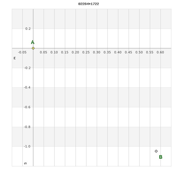
02284+1722 A 2330 (HD 15327)
02h 28m 22.85s +17° 21' 57.6" P.A. 210.00 sep 1.2 mag 9.38,9.56 Sp F5
| Coord 2000 |
02284+1722 |
|
Discov num |
A 2330 |
|
Comp |
|
|
Coord arcsec 2000 |
02 28 22.85 +17 21 57.6 |
|
| Date first |
1910 |
|
Date last |
2018 |
|
Obs |
53 |
|
| Pa first |
165 |
|
Pa last |
210.1 |
|
P.A. Now (θ) |
210.1° |
|
| Sep first |
0.8 |
|
Sep last |
1.211 |
|
Sep. Now (ρ) |
1.211" |
|
| Mag pri |
9.38 |
|
Mag sec |
9.56 |
|
delta mag (ΔM) |
0.18 |
|
Spectral class |
F5 (yellow-white) |
|
| Pri motion ra |
+095 |
|
Sec motion ra |
+095 |
|
| Pri motion dec |
-008 |
|
Sec motion dec |
-008 |
|
| Notes |
O
(Orbital solution) |
|
This double is physical.
OTHER CATALOGS AND DESIGNATIONS
| Name |
HD 15327 |
|
Constellation |
Aries |
|
SAO |
92966 |
|
Tycho2 |
1215-00357-1 |
|
| Gaia DR2 |
82603594175480320 |
|
HD |
15327 |
|
ADS |
1874 |
|
ORBITAL ELEMENTS
| Period (P) | 1124.6993y | ± 568.0166 |
Periastron (T) | 2087.3032y | ± 106.7579 |
Semi-major axis (a) | 3.05697a | ± 1.77503 |
| Eccentricity (e) | 0.78777 | ± 0.17756 |
Inclination (i) | 75.868° | ± 9.035 |
Longitude of periastron (ω) | 246.761° | ± 25.475 |
| Node (Ω) | 47.391° | ± 19.744 |
Notes | | |
Reference | Izm2019 | |
| Equinox | | |
Last observation | 2015 | |
Grade | 5 | (1=Definitive, 9=Indet.) |
| label |
theta |
rho |
| 2000 |
203.4 |
1.186 |
| 2001 |
203.7 |
1.188 |
| 2002 |
204.0 |
1.189 |
| 2003 |
204.4 |
1.191 |
| 2004 |
204.7 |
1.192 |
| 2005 |
205.0 |
1.194 |
| 2006 |
205.3 |
1.195 |
| 2007 |
205.6 |
1.196 |
| 2008 |
205.9 |
1.198 |
| 2009 |
206.2 |
1.199 |
| 2010 |
206.6 |
1.200 |
| 2011 |
206.9 |
1.201 |
| 2012 |
207.2 |
1.202 |
| 2013 |
207.5 |
1.202 |
| 2014 |
207.8 |
1.203 |
| 2015 |
208.1 |
1.204 |
| 2016 |
208.4 |
1.204 |
| 2017 |
208.7 |
1.204 |
| 2018 |
209.0 |
1.205 |
| 2019 |
209.4 |
1.205 |
| 2020 |
209.7 |
1.205 |
| 2021 |
210.0 |
1.205 |
| 2022 |
210.3 |
1.205 |
| 2023 |
210.6 |
1.204 |
| 2024 |
210.9 |
1.204 |
| 2025 |
211.2 |
1.203 |
| 2026 |
211.5 |
1.202 |
| 2027 |
211.8 |
1.201 |
| 2028 |
212.2 |
1.200 |
| 2029 |
212.5 |
1.199 |
| 2030 |
212.8 |
1.198 |
|
|
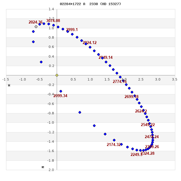
Note: Theta is PA, Rho is Sep. For yearly orbits, data refer to Jan 1st.
|
|
|
|
|
|
|
|
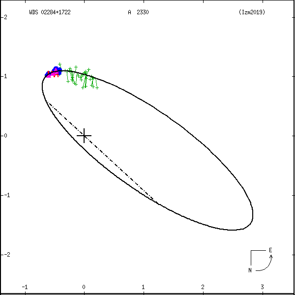
Measures: green=micrometric, blue=interferometric, purple=photographic |
|
WDS 02284+1722 A 2330 (HD 15327) : NOTES
No records found.
REFERENCES
| refcode |
metd |
author |
reference |
| Izm2019 |
orb u |
Izmailov, I.S. |
2019AstL...45...30I |
| Izm2019 |
|
Ast. Lett. 45, 30, 2019 |
|
| Izm2019 |
|
(Orbital elements from weighted solutions used when available (Table 2), |
|
| Izm2019 |
|
unweighted elements (Table 1) used for remaining 29 systems.) |
|
DISCOVERER
| idgroup |
discov |
author |
| 1 |
A |
Aitken, R.G. |
WDS HISTORIC DATA
| coord_2000 |
discov_num |
comp |
epoch |
obs |
pa |
sep |
mag_pri |
mag_sec |
spectr |
notes |
coord_arcsec_2000 |
| 02284+1722 |
A 2330 |
|
2002 |
46 |
205 |
1.2 |
9.38 |
9.56 |
F5 |
|
022822.85+172157.6 |
| 02284+1722 |
A 2330 |
|
2008 |
47 |
204 |
1.2 |
9.38 |
9.56 |
F5 |
|
022822.85+172157.6 |
| 02284+1722 |
A 2330 |
|
2013 |
47 |
207 |
1.2 |
9.38 |
9.56 |
F5 |
|
022822.85+172157.6 |
| 02284+1722 |
A 2330 |
|
2016 |
48 |
211 |
1.2 |
9.38 |
9.56 |
F5 |
|
022822.85+172157.6 |
| 02284+1722 |
A 2330 |
|
2018 |
50 |
210 |
1.2 |
9.38 |
9.56 |
F5 |
|
022822.85+172157.6 |
If you need more information about this double, apply for a
data request form to the WDS.
WDS 02284+1722 A 2330 (HD 15327) : VISUAL OBSERVATIONS REPORTS
No records found.
WDS 02284+1722 A 2330 (HD 15327) : MEASURES
No records found.
WDS 02284+1722 (HD 15327) : VIRTUAL EYEPIECE
Click on the map to see the double of your interest.
Pass over with the mouse cursor to display the catalog designation.
|
|
WDS 02284+1722 (HD 15327) : ALADIN DSS IMAGE @ 02h 28m 22.85s +17° 21' 57.6"
WDS 02284+1722 A 2330 (HD 15327) : NEIGHBORHOODS
|
|
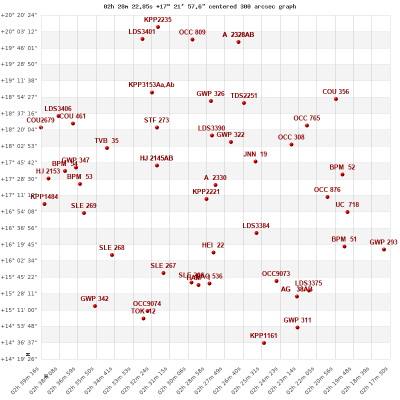
Click on the map to see the double of your interest.
Pass over with the mouse cursor to display the catalog designation.
|
| Show |
name |
coord_2000 |
discov# |
comp |
pa |
sep |
dist(') |
| Show |
|
02284+1722 |
A 2330 |
|
210 |
1.2 |
|
| Show |
|
02289+1707 |
KPP2221 |
|
21 |
18.4 |
17 |
| Show |
|
02259+1747 |
JNN 19 |
|
150 |
0.2 |
44 |
| Show |
|
02274+1807 |
GWP 322 |
|
295 |
11.7 |
48 |
| Show |
|
02286+1814 |
LDS3390 |
|
254 |
10.6 |
52 |
| Show |
|
02320+1743 |
HJ 2145 |
AB |
224 |
15.0 |
57 |
| Show |
|
02320+1743 |
HJ 2145 |
AC |
296 |
26.5 |
57 |
| Show |
|
02259+1631 |
LDS3384 |
|
163 |
176.3 |
63 |
| Show |
|
02285+1611 |
HEI 22 |
|
52 |
2.8 |
71 |
| Show |
|
02237+1804 |
OCC 308 |
|
198 |
0.1 |
80 |
| Show |
|
02320+1822 |
STF 273 |
|
359 |
7.2 |
80 |
| Show |
|
02287+1850 |
GWP 326 |
|
280 |
12.4 |
89 |
| Show |
|
02266+1848 |
TDS2251 |
|
84 |
0.5 |
90 |
| Show |
|
02214+1709 |
OCC 876 |
|
-1 |
0.1 |
101 |
| Show |
|
02227+1825 |
OCC 765 |
|
-1 |
0.1 |
103 |
| Show |
|
02316+1550 |
SLE 267 |
|
225 |
19.8 |
104 |
| Show |
|
02288+1539 |
RAO 536 |
|
138 |
0.7 |
104 |
| Show |
|
02352+1801 |
TVB 35 |
|
233 |
9.0 |
105 |
| Show |
|
02299+1540 |
SLE 266 |
|
93 |
18.5 |
105 |
| Show |
|
02295+1537 |
HAM 1 |
|
194 |
4.4 |
107 |
| Show |
|
02324+1900 |
KPP3153 |
Aa,Ab |
79 |
1.9 |
113 |
| Show |
|
02324+1900 |
LDS3399 |
|
306 |
546.0 |
113 |
| Show |
|
02205+1733 |
BPM 52 |
|
64 |
86.1 |
114 |
| Show |
|
02246+1541 |
OCC9073 |
|
-1 |
0.0 |
115 |
| Show |
|
02349+1608 |
SLE 268 |
|
101 |
18.8 |
119 |
| Show |
|
02368+1723 |
BPM 53 |
|
266 |
78.0 |
122 |
| Show |
|
02366+1653 |
SLE 269 |
|
132 |
10.5 |
122 |
| Show |
|
02201+1653 |
UC 718 |
|
85 |
9.4 |
122 |
| Show |
|
02371+1740 |
GWP 347 |
|
344 |
17.9 |
126 |
| Show |
|
02204+1617 |
BPM 51 |
|
161 |
65.3 |
133 |
| Show |
|
02378+1737 |
BPM 54 |
|
111 |
91.6 |
136 |
| Show |
|
02233+1525 |
AG 38 |
AB |
261 |
34.8 |
138 |
| Show |
|
02233+1525 |
AG 38 |
AC |
186 |
149.3 |
138 |
| Show |
|
02226+1531 |
LDS3375 |
|
338 |
40.9 |
139 |
| Show |
|
02209+1852 |
COU 356 |
|
178 |
0.8 |
141 |
| Show |
|
02373+1826 |
COU 461 |
|
320 |
2.7 |
143 |
| Show |
|
02326+1510 |
OCC9074 |
|
-1 |
0.0 |
146 |
| Show |
|
02388+1729 |
HJ 2153 |
|
353 |
19.8 |
150 |
| Show |
|
02270+1952 |
A 2328 |
AB |
78 |
0.3 |
152 |
| Show |
|
02270+1952 |
GII 72 |
AC |
96 |
1.2 |
152 |
| Show |
|
02298+1954 |
OCC 809 |
|
-1 |
0.1 |
154 |
| Show |
|
02391+1702 |
KPP1484 |
|
266 |
11.1 |
155 |
| Show |
|
02329+1502 |
TOK 12 |
|
334 |
1.4 |
155 |
| Show |
|
02382+1834 |
LDS3406 |
|
60 |
257.1 |
158 |
| Show |
|
02179+1614 |
GWP 293 |
|
72 |
26.6 |
166 |
| Show |
|
02330+1955 |
LDS3401 |
|
340 |
72.1 |
167 |
| Show |
|
02233+1452 |
GWP 311 |
|
189 |
9.2 |
167 |
| Show |
|
02392+1822 |
COU2679 |
|
119 |
1.4 |
167 |
| Show |
|
02359+1515 |
GWP 342 |
|
245 |
23.3 |
167 |
| Show |
|
02254+1436 |
KPP1161 |
|
278 |
9.1 |
172 |
| Show |
|
02320+2008 |
KPP2235 |
|
183 |
18.6 |
174 |
|
|
WDS 02284+1722 : COMPONENTS
02284+1722 A
| Componente originario normalizzato |
AB |
|
Name |
HD 15327 |
|
Coord arcsec 2000 |
022822.85+172157.6 |
|
Mag |
9.38 |
|
| Spectral class |
F5 (yellow-white) |
|
PmRA |
95.00 |
|
PmDE |
-8.0 |
|
SAO |
92966 |
|
| Tycho2 |
1215-00357-1 |
|
HD |
15327 |
|
DM |
BD+16 294 |
|
| Tycho2 |
1215-00357-1 |
|
Pflag |
P |
|
RAmdeg |
37.09520687 |
|
DEmdeg |
17.36600973 |
|
| PmRA |
94.5 |
|
PmDE |
-7.9 |
|
E RAmdeg |
15 |
|
E DEmdeg |
18 |
|
| E pmRA |
1.5 |
|
E pmDE |
1.5 |
|
EpRAm |
1990.42 |
|
EpDEm |
1989.76 |
|
| Num |
6 |
|
Q RAmdeg |
1.5 |
|
Q DEmdeg |
1.3 |
|
Q pmRA |
1.5 |
|
| Q pmDE |
1.3 |
|
BTmag |
9.952 |
|
E BTmag |
0.029 |
|
VTmag |
9.378 |
|
| E VTmag |
0.025 |
|
Prox |
11 |
|
TYC |
T |
|
HIP |
|
|
| CCDM |
|
|
RAdeg |
37.09503333 |
|
DEdeg |
17.36613806 |
|
EpRA 1990 |
1.77 |
|
| EpDE 1990 |
1.74 |
|
E RAdeg |
14.9 |
|
E DEdeg |
17.7 |
|
Posflg |
D |
|
| Corr |
0.0 |
|
| SAO |
92966 |
|
DelFlag |
|
|
RA1950 |
|
|
PmRA1950 |
0.0064 |
|
| DE1950 |
|
|
PmDE1950 |
0.006 |
|
Vmag |
8.4 |
|
SpType |
F5 |
|
| Double code |
|
|
Source |
28 |
|
CatNum |
681 |
|
DM |
BD+16 294 |
|
| DMcomp |
|
|
BDsup |
|
|
HD |
15327 |
|
M HD |
0 |
|
| GC |
|
|
RA1950rad |
0.63532382 |
|
DE1950rad |
0.29920441 |
|
PmRA2000 |
0.0064 |
|
| PmDE2000 |
0.003 |
|
| Ccdm |
02284+1722 |
|
RComp |
|
|
Comp |
A |
|
Note1 |
|
|
| Note2 |
|
|
Discov num |
|
|
DRAs |
-1.12 |
|
DDEs |
-1.8 |
|
| R dRAs |
10 |
|
Year |
|
|
Theta |
|
|
Rho |
|
|
| Obs |
2 |
|
Vmag |
9.4 |
|
Sp |
F5 |
|
PmNote |
* |
|
| PmRA |
105 |
|
PmDE |
7 |
|
Dm number |
+16 294 |
|
Cat1 |
BD |
|
| Name2 |
+17 207 |
|
Cat2 |
AGK2/3 |
|
HD |
15327 |
|
M HD |
|
|
| ADS BDS |
A 1874 |
|
M ADS BDS |
|
|
N IDS |
|
|
IDS |
02228N1655A |
|
| HIC |
|
|
02284+1722 B
| Componente originario normalizzato |
AB |
|
Coord arcsec 2000 |
022822.81+172156.6 |
|
Mag |
9.56 |
|
PmRA |
95.00 |
|
| PmDE |
-8.0 |
|
Tycho2 |
1215-00357-2 |
|
Calc delta mag |
0.18 |
|
Calc coord |
yes |
|
| Tycho2 |
1215-00357-2 |
|
Pflag |
P |
|
RAmdeg |
37.09520687 |
|
DEmdeg |
17.36600973 |
|
| PmRA |
94.5 |
|
PmDE |
-7.9 |
|
E RAmdeg |
15 |
|
E DEmdeg |
18 |
|
| E pmRA |
1.5 |
|
E pmDE |
1.5 |
|
EpRAm |
1990.42 |
|
EpDEm |
1989.76 |
|
| Num |
6 |
|
Q RAmdeg |
1.5 |
|
Q DEmdeg |
1.3 |
|
Q pmRA |
1.5 |
|
| Q pmDE |
1.3 |
|
BTmag |
10.243 |
|
E BTmag |
0.037 |
|
VTmag |
9.557 |
|
| E VTmag |
0.029 |
|
Prox |
11 |
|
TYC |
|
|
HIP |
|
|
| CCDM |
|
|
RAdeg |
37.09489556 |
|
DEdeg |
17.36585167 |
|
EpRA 1990 |
1.77 |
|
| EpDE 1990 |
1.73 |
|
E RAdeg |
20.6 |
|
E DEdeg |
24.6 |
|
Posflg |
D |
|
| Corr |
0.0 |
|
| Ccdm |
02284+1722 |
|
RComp |
|
|
Comp |
B |
|
Note1 |
|
|
| Note2 |
|
|
Discov num |
A 2330 |
|
DRAs |
|
|
DDEs |
|
|
| R dRAs |
|
|
Year |
1957 |
|
Theta |
372 |
|
Rho |
1.0 |
|
| Obs |
20 |
|
Vmag |
9.4 |
|
Sp |
|
|
PmNote |
|
|
| PmRA |
|
|
PmDE |
|
|
Dm number |
|
|
Cat1 |
|
|
| Name2 |
|
|
Cat2 |
|
|
HD |
|
|
M HD |
|
|
| ADS BDS |
A 1874 |
|
M ADS BDS |
|
|
N IDS |
|
|
IDS |
02228N1655B |
|
| HIC |
|
|