18017+4011 STF 2267 (HD 164941)
18h 01m 41.17s +40° 10' 41.9" P.A. 280.00 sep 0.4 mag 8.41,8.84 Sp A3 dist. 249.38 pc (813.48 l.y.)
| Coord 2000 |
18017+4011 |
|
Discov num |
STF2267 |
|
Comp |
|
|
Coord arcsec 2000 |
18 01 41.17 +40 10 41.9 |
|
| Date first |
1830 |
|
Date last |
2018 |
|
Obs |
136 |
|
| Pa first |
234 |
|
Pa last |
280.4 |
|
P.A. Now (θ) |
280.4° |
|
| Sep first |
1.4 |
|
Sep last |
0.434 |
|
Sep. Now (ρ) |
0.434" |
|
| Mag pri |
8.41 |
|
Mag sec |
8.84 |
|
delta mag (ΔM) |
0.43 |
|
Spectral class |
A3 (white) |
|
| Pri motion ra |
-003 |
|
Sec motion ra |
-003 |
|
| Pri motion dec |
+014 |
|
Sec motion dec |
+014 |
|
| Notes |
O
(Orbital solution) |
|
This double is physical.
OTHER CATALOGS AND DESIGNATIONS
| Name |
HD 164941 |
|
Constellation |
Hercules |
|
SAO |
47149 |
|
HIP |
88284 |
|
| Tycho2 |
3106-00396-1 |
|
Gaia DR2 |
4611347682380110080 |
|
HD |
164941 |
|
GC |
24560 |
|
| ADS |
11001 |
|
BD |
BD+40 3263 |
|
Distance |
249.38 |
|
Distance ly |
813.48 |
|
ORBITAL ELEMENTS
| Period (P) | 1660y | |
Periastron (T) | 2121y | |
Semi-major axis (a) | 1.368a | |
| Eccentricity (e) | 0.69 | |
Inclination (i) | 55.5° | |
Longitude of periastron (ω) | 351.9° | |
| Node (Ω) | 37.3° | |
Notes | | |
Reference | Zir2014a | |
| Equinox | 2000 | |
Last observation | 2011 | |
Grade | 4 | (1=Definitive, 9=Indet.) |
| label |
theta |
rho |
| 2000 |
266.9 |
0.607 |
| 2001 |
267.3 |
0.602 |
| 2002 |
267.8 |
0.597 |
| 2003 |
268.3 |
0.591 |
| 2004 |
268.7 |
0.586 |
| 2005 |
269.2 |
0.581 |
| 2006 |
269.7 |
0.575 |
| 2007 |
270.2 |
0.570 |
| 2008 |
270.8 |
0.565 |
| 2009 |
271.3 |
0.559 |
| 2010 |
271.8 |
0.554 |
| 2011 |
272.4 |
0.549 |
| 2012 |
272.9 |
0.544 |
| 2013 |
273.5 |
0.538 |
| 2014 |
274.1 |
0.533 |
| 2015 |
274.7 |
0.528 |
| 2016 |
275.3 |
0.523 |
| 2017 |
275.9 |
0.518 |
| 2018 |
276.5 |
0.513 |
| 2019 |
277.1 |
0.507 |
| 2020 |
277.8 |
0.502 |
| 2021 |
278.5 |
0.497 |
| 2022 |
279.1 |
0.492 |
| 2023 |
279.8 |
0.487 |
| 2024 |
280.5 |
0.483 |
| 2025 |
281.3 |
0.478 |
| 2026 |
282.0 |
0.473 |
| 2027 |
282.8 |
0.468 |
| 2028 |
283.5 |
0.463 |
| 2029 |
284.3 |
0.459 |
| 2030 |
285.1 |
0.454 |
|
|
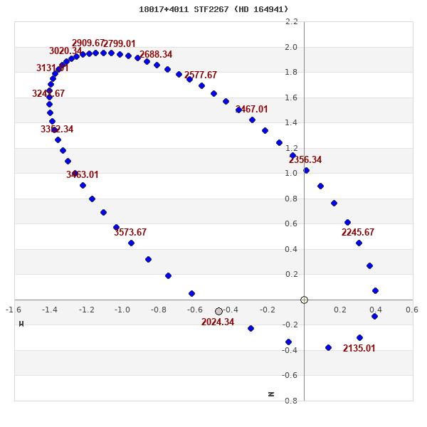
Note: Theta is PA, Rho is Sep. For yearly orbits, data refer to Jan 1st.
|
|
|
|
|
|
|
|
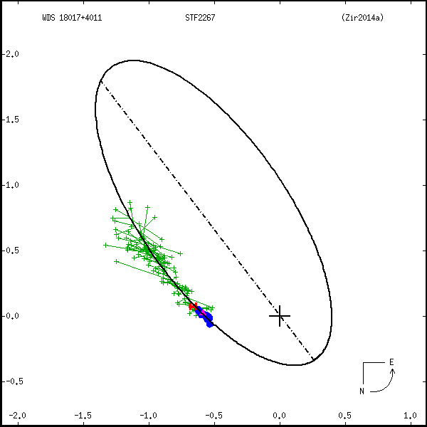
Measures: green=micrometric, blue=interferometric, purple=photographic |
|
WDS 18017+4011 STF 2267 (HD 164941) : NOTES
No records found.
REFERENCES
| refcode |
metd |
author |
reference |
| Zir2014a |
orb - |
Zirm, H. |
2014IAUDS.182....1Z |
| Zir2014a |
|
Inf. Circ. 182, 1, 2014 |
|
DISCOVERER
| idgroup |
discov |
author |
| 1 |
STF |
Struve, F.G.W. |
WDS HISTORIC DATA
| coord_2000 |
discov_num |
comp |
epoch |
obs |
pa |
sep |
mag_pri |
mag_sec |
spectr |
notes |
coord_arcsec_2000 |
| 18017+4011 |
STF2267 |
|
2005 |
124 |
269 |
0.5 |
8.41 |
8.84 |
A3 |
D |
180141.17+401041.9 |
| 18017+4011 |
STF2267 |
|
2006 |
126 |
270 |
0.6 |
8.41 |
8.84 |
A3 |
D |
180141.17+401041.9 |
| 18017+4011 |
STF2267 |
|
2010 |
129 |
272 |
0.6 |
8.41 |
8.84 |
A3 |
D |
180141.17+401041.9 |
| 18017+4011 |
STF2267 |
|
2011 |
133 |
272 |
0.5 |
8.41 |
8.84 |
A3 |
O |
180141.17+401041.9 |
| 18017+4011 |
STF2267 |
|
2016 |
133 |
276 |
0.5 |
8.41 |
8.84 |
A3 |
O |
180141.17+401041.9 |
| 18017+4011 |
STF2267 |
|
2018 |
135 |
281 |
0.4 |
8.41 |
8.84 |
A3 |
O |
180141.17+401041.9 |
If you need more information about this double, apply for a
data request form to the WDS.
WDS 18017+4011 STF 2267 (HD 164941) : VISUAL OBSERVATIONS REPORTS
No records found.
WDS 18017+4011 STF 2267 (HD 164941) : MEASURES
No records found.
WDS 18017+4011 (HD 164941) : VIRTUAL EYEPIECE

Click on the map to see the double of your interest.
Pass over with the mouse cursor to display the catalog designation.
|
|
WDS 18017+4011 (HD 164941) : ALADIN DSS IMAGE @ 18h 01m 41.17s +40° 10' 41.9"
WDS 18017+4011 STF 2267 (HD 164941) : NEIGHBORHOODS
|
|

Click on the map to see the double of your interest.
Pass over with the mouse cursor to display the catalog designation.
|
| Show |
name |
coord_2000 |
discov# |
comp |
pa |
sep |
dist(') |
| Show |
|
18017+4011 |
STF2267 |
|
280 |
0.4 |
|
| Show |
|
18015+4019 |
HO 77 |
|
312 |
2.0 |
10 |
| Show |
|
18035+4032 |
COU1785 |
|
30 |
0.2 |
30 |
| Show |
|
18018+4052 |
BVD 259 |
|
277 |
10.6 |
41 |
| Show |
|
18032+3926 |
MLB 851 |
|
34 |
6.7 |
48 |
| Show |
|
18040+3923 |
L 19 |
|
274 |
0.2 |
51 |
| Show |
|
17592+3926 |
COU1458 |
|
78 |
0.4 |
53 |
| Show |
|
18033+3921 |
STF2275 |
|
124 |
0.3 |
54 |
| Show |
|
17590+4058 |
BRT 345 |
|
138 |
2.8 |
56 |
| Show |
|
18065+4022 |
STF2282 |
AB |
83 |
2.7 |
57 |
| Show |
|
18065+4022 |
STF2282 |
AC |
80 |
2.7 |
57 |
| Show |
|
18065+4022 |
STF2282 |
BC |
48 |
0.2 |
57 |
| Show |
|
17575+3942 |
COU1457 |
|
7 |
1.9 |
57 |
| Show |
|
18029+4109 |
ES 1648 |
|
9 |
3.7 |
61 |
| Show |
|
18058+4054 |
TDT 677 |
|
231 |
0.5 |
65 |
| Show |
|
17592+4115 |
COU1783 |
|
47 |
2.8 |
72 |
| Show |
|
18079+4002 |
ES 1649 |
AB |
331 |
7.8 |
72 |
| Show |
|
18079+4002 |
ES 1649 |
AC |
226 |
24.4 |
72 |
| Show |
|
18038+3857 |
LDS4773 |
AB |
304 |
72.4 |
78 |
| Show |
|
17562+3926 |
BU 417 |
|
317 |
1.0 |
78 |
| Show |
|
17572+4112 |
KPP4072 |
|
266 |
1.5 |
80 |
| Show |
|
17554+3930 |
STF2246 |
|
100 |
5.5 |
83 |
| Show |
|
17569+4115 |
STF2255 |
|
343 |
9.1 |
85 |
| Show |
|
17555+4108 |
COU1601 |
Aa,Ab |
63 |
0.5 |
91 |
| Show |
|
17555+4108 |
ES 1557 |
AB |
11 |
11.5 |
91 |
| Show |
|
17555+4108 |
ES 1557 |
AC |
216 |
27.0 |
91 |
| Show |
|
17555+4108 |
ES 1557 |
AD |
312 |
40.1 |
91 |
| Show |
|
17555+4108 |
ABH 92 |
AE |
324 |
71.1 |
91 |
| Show |
|
18097+4001 |
TDT 714 |
|
312 |
0.8 |
93 |
| Show |
|
17538+3951 |
SLW1216 |
|
359 |
13.9 |
94 |
| Show |
|
18077+3904 |
ES 2018 |
|
236 |
5.7 |
94 |
| Show |
|
17550+4107 |
UC 3444 |
|
130 |
12.0 |
95 |
| Show |
|
17540+3936 |
KPP 883 |
|
102 |
7.4 |
95 |
| Show |
|
18007+4145 |
ES 1558 |
|
298 |
6.3 |
95 |
| Show |
|
17572+4131 |
COU1782 |
|
190 |
0.4 |
97 |
| Show |
|
17533+4000 |
BU 130 |
|
110 |
1.6 |
97 |
| Show |
|
17541+3928 |
HLM 9 |
|
285 |
5.3 |
98 |
| Show |
|
17548+4110 |
RAO 605 |
|
104 |
0.8 |
98 |
| Show |
|
18031+4158 |
DOO 10 |
|
292 |
4.9 |
99 |
| Show |
|
17537+3924 |
TDT 560 |
|
198 |
2.5 |
103 |
| Show |
|
17528+4038 |
TDT 552 |
|
226 |
1.3 |
106 |
| Show |
|
18051+3819 |
J 1218 |
|
167 |
3.1 |
109 |
| Show |
|
18064+3837 |
ES 2017 |
|
268 |
2.6 |
109 |
| Show |
|
17525+3943 |
COU1302 |
|
172 |
4.0 |
110 |
| Show |
|
18019+4202 |
DAM 103 |
|
206 |
11.0 |
112 |
| Show |
|
18026+4204 |
UC 3480 |
|
18 |
23.8 |
114 |
| Show |
|
18117+4020 |
UC 3526 |
|
137 |
25.0 |
116 |
| Show |
|
17523+4057 |
A 699 |
|
26 |
0.1 |
117 |
| Show |
|
18028+3815 |
ALI 867 |
|
246 |
11.4 |
117 |
| Show |
|
18043+4206 |
COU1786 |
Aa,Ab |
11 |
0.2 |
119 |
| Show |
|
18043+4206 |
ROE 1 |
AB |
186 |
24.3 |
119 |
|
|
WDS 18017+4011 : COMPONENTS
18017+4011 A
| Componente originario normalizzato |
AB |
|
Name |
HD 164941 |
|
Coord arcsec 2000 |
180141.17+401041.9 |
|
Mag |
8.41 |
|
| Spectral class |
A3 (white) |
|
PmRA |
-3.00 |
|
PmDE |
14.0 |
|
SAO |
47149 |
|
| HIP |
88284 |
|
Tycho2 |
3106-00396-1 |
|
HD |
164941 |
|
GC |
24560 |
|
| BD |
BD+40 3263 |
|
| Tycho2 |
3106-00396-1 |
|
Pflag |
|
|
RAmdeg |
270.42143790 |
|
DEmdeg |
40.17830201 |
|
| PmRA |
-3.0 |
|
PmDE |
13.5 |
|
E RAmdeg |
6 |
|
E DEmdeg |
6 |
|
| E pmRA |
1.1 |
|
E pmDE |
1.1 |
|
EpRAm |
1991.14 |
|
EpDEm |
1991.11 |
|
| Num |
9 |
|
Q RAmdeg |
1.0 |
|
Q DEmdeg |
1.3 |
|
Q pmRA |
1.0 |
|
| Q pmDE |
1.5 |
|
BTmag |
8.431 |
|
E BTmag |
0.016 |
|
VTmag |
8.010 |
|
| E VTmag |
0.012 |
|
Prox |
999 |
|
TYC |
T |
|
HIP |
88284 |
|
| CCDM |
AB |
|
RAdeg |
270.42144667 |
|
DEdeg |
40.17827083 |
|
EpRA 1990 |
1.65 |
|
| EpDE 1990 |
1.59 |
|
E RAdeg |
6.0 |
|
E DEdeg |
5.7 |
|
Posflg |
P |
|
| Corr |
-0.1 |
|
| SAO |
47149 |
|
DelFlag |
|
|
RA1950 |
|
|
PmRA1950 |
0.0003 |
|
| DE1950 |
|
|
PmDE1950 |
0.006 |
|
Vmag |
7.8 |
|
SpType |
A3 |
|
| Double code |
|
|
Source |
70 |
|
CatNum |
24560 |
|
DM |
BD+40 3263 |
|
| DMcomp |
|
|
BDsup |
|
|
HD |
164941 |
|
M HD |
0 |
|
| GC |
24560 |
|
RA1950rad |
4.71266816 |
|
DE1950rad |
0.70121793 |
|
PmRA2000 |
0.0007 |
|
| PmDE2000 |
0.007 |
|
| Catalog |
H |
|
HIP |
88284 |
|
Proxy |
H |
|
RAhms |
18 01 41.17 |
|
| DEdms |
+40 10 41.8 |
|
Vmag |
7.86 |
|
VarFlag |
|
|
R Vmag |
H |
|
| RAdeg |
270.422 |
|
DEdeg |
40.1783 |
|
AstroRef |
A |
|
Plx |
5.98 |
|
| CCDM |
18017+4011 |
|
N CCDM |
I |
|
Nsys |
1 |
|
Ncomp |
2 |
|
| MultFlag |
C |
|
Source |
|
|
Qual |
A |
|
M HIP |
AB |
|
| Theta |
263 |
|
Rho |
0.664 |
|
HD |
164941 |
|
BD |
BD+40 3263 |
|
| CD |
|
|
CP |
|
|
Dm number |
+40 3263 |
|
VIred |
0.48 |
|
| SpType |
A3 |
|
R SpType |
|
|
Coord arcsec 2000 |
180141.17+401041.8 |
|
| HIP |
88284 |
|
Sn |
15 |
|
So |
3 |
|
Nc |
2 |
|
| RArad |
4.7197465317 |
|
DErad |
0.7012432506 |
|
Plx |
4.01 |
|
PmRA |
-10.08 |
|
| PmDE |
14.13 |
|
E RArad |
1.8 |
|
E DErad |
0.8 |
|
E Plx |
1.03 |
|
| E pmRA |
2.71 |
|
E pmDE |
0.96 |
|
Hpmag |
7.9514 |
|
E Hpmag |
0.0016 |
|
| SHp |
0.014 |
|
VA |
0 |
|
BV |
0.393 |
|
E BV |
0.017 |
|
| VI |
0.46 |
|
| Ccdm |
18017+4011 |
|
RComp |
|
|
Comp |
A |
|
Note1 |
|
|
| Note2 |
|
|
Discov num |
|
|
DRAs |
-0.87 |
|
DDEs |
-18.7 |
|
| R dRAs |
10 |
|
Year |
|
|
Theta |
|
|
Rho |
|
|
| Obs |
2 |
|
Vmag |
8.6 |
|
Sp |
A3 |
|
PmNote |
* |
|
| PmRA |
-6 |
|
PmDE |
7 |
|
Dm number |
+40 3263 |
|
Cat1 |
BD |
|
| Name2 |
+40 1643 |
|
Cat2 |
AGK2/3 |
|
HD |
164941 |
|
M HD |
|
|
| ADS BDS |
A11001 |
|
M ADS BDS |
|
|
N IDS |
|
|
IDS |
17584N4011A |
|
| HIC |
88284 |
|
18017+4011 B
| Componente originario normalizzato |
AB |
|
Coord arcsec 2000 |
180141.14+401042.0 |
|
Mag |
8.84 |
|
PmRA |
-3.00 |
|
| PmDE |
14.0 |
|
Calc delta mag |
0.43 |
|
Calc coord |
yes |
|
| Ccdm |
18017+4011 |
|
RComp |
|
|
Comp |
B |
|
Note1 |
|
|
| Note2 |
|
|
Discov num |
STF2267 |
|
DRAs |
|
|
DDEs |
|
|
| R dRAs |
|
|
Year |
1959 |
|
Theta |
255 |
|
Rho |
0.8 |
|
| Obs |
99 |
|
Vmag |
8.6 |
|
Sp |
|
|
PmNote |
|
|
| PmRA |
|
|
PmDE |
|
|
Dm number |
|
|
Cat1 |
|
|
| Name2 |
|
|
Cat2 |
|
|
HD |
|
|
M HD |
|
|
| ADS BDS |
A11001 |
|
M ADS BDS |
|
|
N IDS |
|
|
IDS |
17584N4011B |
|
| HIC |
88284 |
|