00002+0146 WEI 45 (HD 224725)
00h 00m 12.14s +01° 46' 17.2" P.A. 83.00 sep 1.8 mag 10.09,10.52 Sp G0
| Coord 2000 |
00002+0146 |
|
Discov num |
WEI 45 |
|
Comp |
|
|
Coord arcsec 2000 |
00 00 12.14 +01 46 17.2 |
|
| Date first |
1879 |
|
Date last |
2015 |
|
Obs |
26 |
|
| Pa first |
89 |
|
Pa last |
82.5 |
|
P.A. Now (θ) |
82.5° |
|
| Sep first |
1.8 |
|
Sep last |
1.835 |
|
Sep. Now (ρ) |
1.835" |
|
| Mag pri |
10.09 |
|
Mag sec |
10.52 |
|
delta mag (ΔM) |
0.43 |
|
Spectral class |
G0 (yellow) |
|
| Pri motion ra |
+032 |
|
Sec motion ra |
+032 |
|
| Pri motion dec |
-021 |
|
Sec motion dec |
-021 |
|
| Notes |
N
(See Notes) |
|
Nature of this double is uncertain.
OTHER CATALOGS AND DESIGNATIONS
| Name |
HD 224725 |
|
Constellation |
Pisces |
|
Tycho2 |
0001-00017-2 |
|
Gaia DR2 |
2738669098678782848 |
|
| HD |
224725 |
|
ADS |
17156 |
|
WDS 00002+0146 WEI 45 (HD 224725) : NOTES
| discov_num |
notes |
refcode |
| WEI 45 |
HWE 64 is certainly identical with Weisse 45 = ADS 17156. Howe misread |
|
|
the sign of the declination. This was already stated in Cin. Pub v 6, |
|
|
nos 748 and 749, and the mean of the two measures is given in the mean |
|
|
results, assigned to Weisse 45. Nevertheless the pair was given |
|
|
separately in the BDS and 12692 and taken over as ADS 17168. ADS 17156 |
|
|
is misidentified. It is BD+00 5079 (9.1), 9.5, G0, with the position |
|
|
for 1900 (1950) as 23 55.1 (57.6) +01 13 (30). |
B__1950c |
REFERENCES
| refcode |
metd |
author |
reference |
| B__1950c |
Ma - |
van den Bos, W.H. |
1950CiUO..109..371V |
| B__1950c |
|
Union Obs. Johannesburg Circ. 109, 371, 1950 |
|
DISCOVERER
| idgroup |
discov |
author |
| 1 |
WEI |
Weisse, M. |
WDS HISTORIC DATA
| coord_2000 |
discov_num |
comp |
epoch |
obs |
pa |
sep |
mag_pri |
mag_sec |
spectr |
notes |
coord_arcsec_2000 |
| 00002+0146 |
WEI 45 |
|
1999 |
18 |
82 |
1.9 |
10.09 |
10.52 |
G0 |
N |
000012.14+014617.2 |
| 00002+0146 |
WEI 45 |
|
2005 |
19 |
84 |
1.8 |
10.09 |
10.52 |
G0 |
N |
000012.14+014617.2 |
| 00002+0146 |
WEI 45 |
|
2009 |
20 |
84 |
1.8 |
10.09 |
10.52 |
G0 |
N |
000012.14+014617.2 |
| 00002+0146 |
WEI 45 |
|
2015 |
25 |
83 |
1.8 |
10.09 |
10.52 |
G0 |
N |
000012.14+014617.2 |
If you need more information about this double, apply for a
data request form to the WDS.
WDS 00002+0146 WEI 45 (HD 224725) : VISUAL OBSERVATIONS REPORTS
No records found.
WDS 00002+0146 WEI 45 (HD 224725) : MEASURES
No records found.
WDS 00002+0146 (HD 224725) : VIRTUAL EYEPIECE
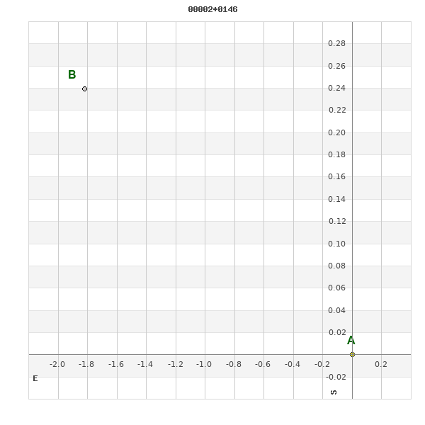
Click on the map to see the double of your interest.
Pass over with the mouse cursor to display the catalog designation.
|
|
WDS 00002+0146 (HD 224725) : ALADIN DSS IMAGE @ 00h 00m 12.14s +01° 46' 17.2"
WDS 00002+0146 WEI 45 (HD 224725) : NEIGHBORHOODS
|
|
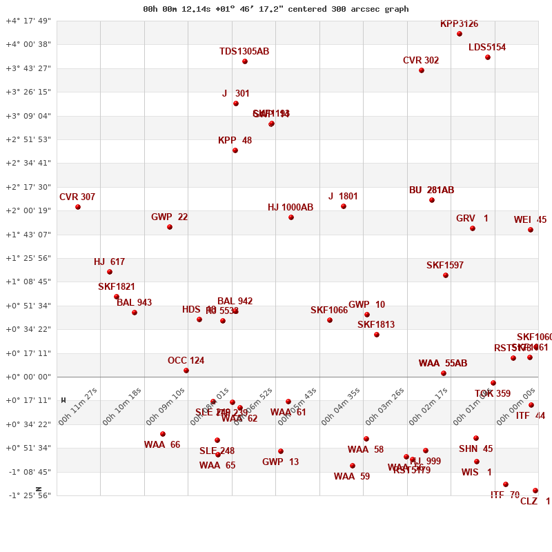
Click on the map to see the double of your interest.
Pass over with the mouse cursor to display the catalog designation.
|
| Show |
name |
coord_2000 |
discov# |
comp |
pa |
sep |
dist(') |
| Show |
|
00002+0146 |
WEI 45 |
|
83 |
1.8 |
|
| Show |
|
00017+0147 |
GRV 1 |
|
350 |
73.3 |
23 |
| Show |
|
00028+0208 |
BU 281 |
AB |
159 |
1.6 |
45 |
| Show |
|
00028+0208 |
HJ 998 |
AC |
329 |
46.3 |
45 |
| Show |
|
00024+0114 |
SKF1597 |
|
34 |
3.0 |
47 |
| Show |
|
00016-0045 |
SHN 45 |
|
-1 |
0.2 |
66 |
| Show |
|
00030-0054 |
HJ 999 |
|
76 |
26.0 |
67 |
| Show |
|
00035-0058 |
WAA 56 |
|
148 |
4.9 |
69 |
| Show |
|
00052+0204 |
J 1801 |
|
52 |
2.7 |
76 |
| Show |
|
00001+0022 |
SKF1060 |
|
184 |
2.2 |
85 |
| Show |
|
00002-0021 |
ITF 44 |
|
31 |
3.9 |
86 |
| Show |
|
00045+0045 |
GWP 10 |
|
35 |
20.3 |
89 |
| Show |
|
00045-0045 |
WAA 58 |
|
15 |
2.6 |
90 |
| Show |
|
00002+0014 |
SKF1061 |
|
173 |
1.4 |
93 |
| Show |
|
00007+0013 |
RST5178 |
|
338 |
2.4 |
94 |
| Show |
|
00065+0155 |
HJ 1000 |
AB |
205 |
7.3 |
95 |
| Show |
|
00042+0031 |
SKF1813 |
|
154 |
1.8 |
97 |
| Show |
|
00055+0041 |
SKF1066 |
|
315 |
2.6 |
103 |
| Show |
|
00012-0005 |
TOK 359 |
|
72 |
0.3 |
103 |
| Show |
|
00025+0003 |
WAA 55 |
AB |
209 |
1.4 |
110 |
| Show |
|
00025+0003 |
WAA 55 |
AC |
190 |
4.1 |
110 |
| Show |
|
00067-0054 |
GWP 13 |
|
91 |
81.6 |
112 |
| Show |
|
00030+0341 |
CVR 302 |
|
205 |
13.2 |
123 |
| Show |
|
00013+0351 |
LDS5154 |
|
94 |
163.7 |
127 |
| Show |
|
00070+0303 |
GWP 14 |
|
136 |
10.3 |
128 |
| Show |
|
00069+0303 |
SKF1193 |
|
61 |
4.2 |
128 |
| Show |
|
00079+0244 |
KPP 48 |
|
126 |
4.9 |
130 |
| Show |
|
00065-0018 |
WAA 61 |
|
339 |
1.3 |
130 |
| Show |
|
00079+0047 |
BAL 942 |
|
299 |
7.2 |
130 |
| Show |
|
00084-0056 |
WAA 65 |
|
37 |
3.9 |
133 |
| Show |
|
00084-0046 |
SLE 248 |
|
162 |
14.3 |
137 |
| Show |
|
00081+0040 |
HJ 5533 |
|
73 |
26.4 |
138 |
| Show |
|
00078-0023 |
WAA 62 |
|
347 |
2.5 |
142 |
| Show |
|
00096+0148 |
GWP 22 |
|
9 |
10.9 |
142 |
| Show |
|
00021+0408 |
KPP3126 |
|
62 |
1.9 |
145 |
| Show |
|
00089+0042 |
HDS 18 |
|
152 |
0.3 |
146 |
| Show |
|
00080-0019 |
ITF 239 |
|
91 |
4.5 |
147 |
| Show |
|
00079+0317 |
J 301 |
|
180 |
4.4 |
148 |
| Show |
|
00085-0018 |
SLE 249 |
|
279 |
12.5 |
153 |
| Show |
|
00098-0042 |
WAA 66 |
|
337 |
4.7 |
159 |
| Show |
|
00077+0348 |
TDS1305 |
AB |
61 |
0.5 |
166 |
| Show |
|
00106+0047 |
BAL 943 |
|
279 |
4.3 |
167 |
| Show |
|
00112+0116 |
HJ 617 |
|
61 |
13.1 |
168 |
| Show |
|
00092+0004 |
OCC 124 |
|
-1 |
0.1 |
170 |
| Show |
|
00016-0102 |
WIS 1 |
|
234 |
999.9 |
170 |
| Show |
|
00110+0058 |
SKF1821 |
|
13 |
1.8 |
170 |
| Show |
|
00033-0100 |
RST5179 |
|
191 |
1.1 |
173 |
| Show |
|
00121+0203 |
CVR 307 |
|
78 |
22.8 |
179 |
| Show |
|
00049-0104 |
WAA 59 |
|
331 |
2.6 |
185 |
| Show |
|
00009-0118 |
ITF 70 |
|
321 |
2.3 |
185 |
| Show |
|
00001-0122 |
CLZ 1 |
|
347 |
6.2 |
189 |
|
|
WDS 00002+0146 : COMPONENTS
00002+0146 A
| Componente originario normalizzato |
AB |
|
Name |
HD 224725 |
|
Coord arcsec 2000 |
000012.14+014617.2 |
|
Mag |
10.09 |
|
| Spectral class |
G0 (yellow) |
|
PmRA |
32.00 |
|
PmDE |
-21.0 |
|
Tycho2 |
0001-00017-2 |
|
| HD |
224725 |
|
ADS |
17156 |
|
DM |
BD+00 5079 |
|
| Tycho2 |
0001-00017-2 |
|
Pflag |
P |
|
RAmdeg |
0.05059802 |
|
DEmdeg |
1.77144349 |
|
| PmRA |
32.1 |
|
PmDE |
-20.7 |
|
E RAmdeg |
21 |
|
E DEmdeg |
31 |
|
| E pmRA |
1.6 |
|
E pmDE |
1.6 |
|
EpRAm |
1989.29 |
|
EpDEm |
1985.38 |
|
| Num |
5 |
|
Q RAmdeg |
1.4 |
|
Q DEmdeg |
0.6 |
|
Q pmRA |
1.4 |
|
| Q pmDE |
0.6 |
|
BTmag |
10.772 |
|
E BTmag |
0.048 |
|
VTmag |
10.093 |
|
| E VTmag |
0.038 |
|
Prox |
18 |
|
TYC |
|
|
HIP |
|
|
| CCDM |
|
|
RAdeg |
0.05037611 |
|
DEdeg |
1.77148194 |
|
EpRA 1990 |
1.78 |
|
| EpDE 1990 |
1.57 |
|
E RAdeg |
21.4 |
|
E DEdeg |
32.6 |
|
Posflg |
D |
|
| Corr |
-0.2 |
|
| Ccdm |
00002+0146 |
|
RComp |
|
|
Comp |
A |
|
Note1 |
|
|
| Note2 |
|
|
Discov num |
|
|
DRAs |
0.14 |
|
DDEs |
17.7 |
|
| R dRAs |
10 |
|
Year |
|
|
Theta |
|
|
Rho |
|
|
| Obs |
2 |
|
Vmag |
10.0 |
|
Sp |
G0 |
|
PmNote |
* |
|
| PmRA |
40 |
|
PmDE |
-13 |
|
Dm number |
+00 5079 |
|
Cat1 |
BD |
|
| Name2 |
+01 2875 |
|
Cat2 |
AGK2/3 |
|
HD |
224725 |
|
M HD |
|
|
| ADS BDS |
A17156 |
|
M ADS BDS |
|
|
N IDS |
|
|
IDS |
23551N0113A |
|
| HIC |
|
|
00002+0146 B
| Componente originario normalizzato |
AB |
|
Coord arcsec 2000 |
000012.26+014617.4 |
|
Mag |
10.52 |
|
PmRA |
32.00 |
|
| PmDE |
-21.0 |
|
Tycho2 |
0001-00017-1 |
|
Calc delta mag |
0.43 |
|
Calc coord |
yes |
|
| Tycho2 |
0001-00017-1 |
|
Pflag |
P |
|
RAmdeg |
0.05059802 |
|
DEmdeg |
1.77144349 |
|
| PmRA |
32.1 |
|
PmDE |
-20.7 |
|
E RAmdeg |
21 |
|
E DEmdeg |
31 |
|
| E pmRA |
1.6 |
|
E pmDE |
1.6 |
|
EpRAm |
1989.29 |
|
EpDEm |
1985.38 |
|
| Num |
5 |
|
Q RAmdeg |
1.4 |
|
Q DEmdeg |
0.6 |
|
Q pmRA |
1.4 |
|
| Q pmDE |
0.6 |
|
BTmag |
11.318 |
|
E BTmag |
0.070 |
|
VTmag |
10.521 |
|
| E VTmag |
0.051 |
|
Prox |
18 |
|
TYC |
T |
|
HIP |
|
|
| CCDM |
|
|
RAdeg |
0.05086583 |
|
DEdeg |
1.77151389 |
|
EpRA 1990 |
1.78 |
|
| EpDE 1990 |
1.55 |
|
E RAdeg |
30.0 |
|
E DEdeg |
45.6 |
|
Posflg |
D |
|
| Corr |
-0.2 |
|
| Ccdm |
00002+0146 |
|
RComp |
|
|
Comp |
B |
|
Note1 |
|
|
| Note2 |
|
|
Discov num |
WEI 45 |
|
DRAs |
|
|
DDEs |
|
|
| R dRAs |
|
|
Year |
1879 |
|
Theta |
088 |
|
Rho |
1.8 |
|
| Obs |
11 |
|
Vmag |
10.5 |
|
Sp |
|
|
PmNote |
|
|
| PmRA |
|
|
PmDE |
|
|
Dm number |
|
|
Cat1 |
|
|
| Name2 |
|
|
Cat2 |
|
|
HD |
|
|
M HD |
|
|
| ADS BDS |
A17156 |
|
M ADS BDS |
N |
|
N IDS |
|
|
IDS |
23551N0113B |
|
| HIC |
|
|