00090-5400 HDO 181 (HD 469)
00h 09m 02.35s -54° 00' 07.1" P.A. 15.00 sep 0.4 mag 6.74,8.07 Sp G4IV dist. 128.37 pc (418.74 l.y.)
| Coord 2000 |
00090-5400 |
|
Discov num |
HDO 181 |
|
Comp |
|
|
Coord arcsec 2000 |
00 09 02.35 -54 00 07.1 |
|
| Date first |
1897 |
|
Date last |
2018 |
|
Obs |
47 |
|
| Pa first |
300 |
|
Pa last |
15.4 |
|
P.A. Now (θ) |
8.5° |
|
| Sep first |
1.2 |
|
Sep last |
0.382 |
|
Sep. Now (ρ) |
0.4" |
|
| Mag pri |
6.74 |
|
Mag sec |
8.07 |
|
delta mag (ΔM) |
1.33 |
|
Spectral class |
G4IV (yellow) |
|
| Pri motion ra |
+047 |
|
Sec motion ra |
|
|
| Pri motion dec |
+017 |
|
Sec motion dec |
|
|
| Notes |
N
O
(See Notes, Orbital solution) |
|
This double is physical.
OTHER CATALOGS AND DESIGNATIONS
| Name |
HD 469 |
|
Constellation |
Phoenix |
|
SAO |
231943 |
|
HIP |
730 |
|
| Tycho2 |
8464-00766-1 |
|
Gaia DR2 |
4923991064959730816 |
|
HD |
469 |
|
HR |
23 |
|
| GC |
148 |
|
CP |
CP-54 19 |
|
Distance |
128.37 |
|
Distance ly |
418.74 |
|
ORBITAL ELEMENTS
| Period (P) | 201.9y | |
Periastron (T) | 1981.29y | |
Semi-major axis (a) | 0.4a | |
| Eccentricity (e) | 0.38 | |
Inclination (i) | 158.6° | |
Longitude of periastron (ω) | 13.2° | |
| Node (Ω) | 141.5° | |
Notes | n | |
Reference | Alz2020b | |
| Equinox | 2000 | |
Last observation | 2018 | |
Grade | 3 | (1=Definitive, 9=Indet.) |
| label |
theta |
rho |
| 2000 |
59.1 |
0.282 |
| 2001 |
56.1 |
0.286 |
| 2002 |
53.1 |
0.291 |
| 2003 |
50.2 |
0.295 |
| 2004 |
47.5 |
0.300 |
| 2005 |
44.8 |
0.305 |
| 2006 |
42.2 |
0.310 |
| 2007 |
39.7 |
0.315 |
| 2008 |
37.2 |
0.320 |
| 2009 |
34.9 |
0.325 |
| 2010 |
32.6 |
0.331 |
| 2011 |
30.4 |
0.336 |
| 2012 |
28.2 |
0.341 |
| 2013 |
26.2 |
0.347 |
| 2014 |
24.2 |
0.352 |
| 2015 |
22.2 |
0.358 |
| 2016 |
20.3 |
0.363 |
| 2017 |
18.5 |
0.368 |
| 2018 |
16.7 |
0.374 |
| 2019 |
15.0 |
0.379 |
| 2020 |
13.3 |
0.384 |
| 2021 |
11.6 |
0.390 |
| 2022 |
10.0 |
0.395 |
| 2023 |
8.5 |
0.400 |
| 2024 |
7.0 |
0.405 |
| 2025 |
5.5 |
0.410 |
| 2026 |
4.0 |
0.415 |
| 2027 |
2.6 |
0.420 |
| 2028 |
1.2 |
0.425 |
| 2029 |
359.9 |
0.429 |
| 2030 |
358.6 |
0.434 |
|
|
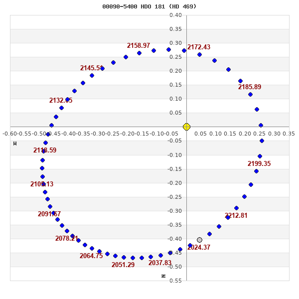
Note: Theta is PA, Rho is Sep. For yearly orbits, data refer to Jan 1st.
|
|
|
|
|
|
|
|
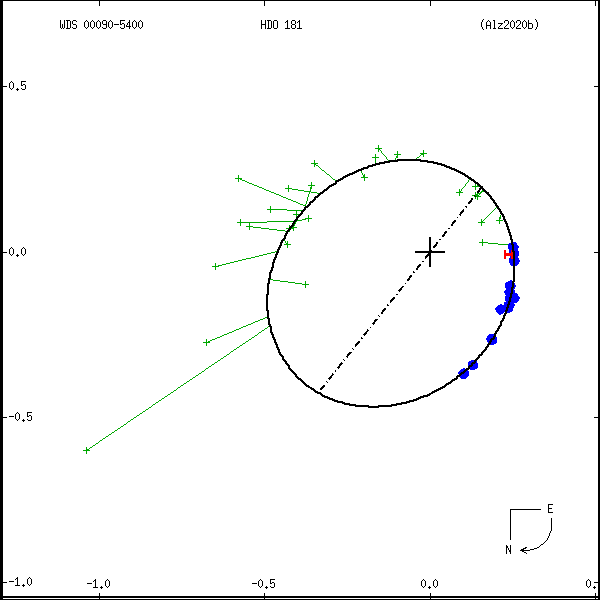
Measures: green=micrometric, blue=interferometric, purple=photographic |
|
WDS 00090-5400 HDO 181 (HD 469) : NOTES
| discov_num |
notes |
refcode |
| HDO 181 |
Spectroscopic binary. |
|
|
Quoted errors in P and a are +116/-40y, +0".20/-0".06, respectively. |
Ary2002b |
REFERENCES
| refcode |
metd |
author |
reference |
| Alz2020b |
orb - |
Alzner, A., Argyle, R., & Horch |
2020IAUDS.201....1A |
| Alz2020b |
|
Inf. Circ. 201, 1, 2020 |
|
| Ary2002b |
orb - |
Argyle, R.W., Alzner, A. & Horch, E. |
2002A&A...384..171A |
| Ary2002b |
|
A&A 384, 171, 2002 |
|
DISCOVERER
| idgroup |
discov |
author |
| 1 |
HDO |
Harvard Obs. |
WDS HISTORIC DATA
| coord_2000 |
discov_num |
comp |
epoch |
obs |
pa |
sep |
mag_pri |
mag_sec |
spectr |
notes |
coord_arcsec_2000 |
| 00090-5400 |
HDO 181 |
|
2001 |
38 |
234 |
0.3 |
6.74 |
8.07 |
G4IV |
NOD |
000902.35-540007.1 |
| 00090-5400 |
HDO 181 |
|
2008 |
44 |
35 |
0.3 |
6.74 |
8.07 |
G4IV |
NOD |
000902.35-540007.1 |
| 00090-5400 |
HDO 181 |
|
2015 |
46 |
21 |
0.4 |
6.74 |
8.07 |
G4IV |
NO |
000902.35-540007.1 |
| 00090-5400 |
HDO 181 |
|
2018 |
47 |
15 |
0.4 |
6.74 |
8.07 |
G4IV |
NO |
000902.35-540007.1 |
If you need more information about this double, apply for a
data request form to the WDS.
WDS 00090-5400 HDO 181 (HD 469) : VISUAL OBSERVATIONS REPORTS
No records found.
WDS 00090-5400 HDO 181 (HD 469) : MEASURES
No records found.
WDS 00090-5400 (HD 469) : VIRTUAL EYEPIECE
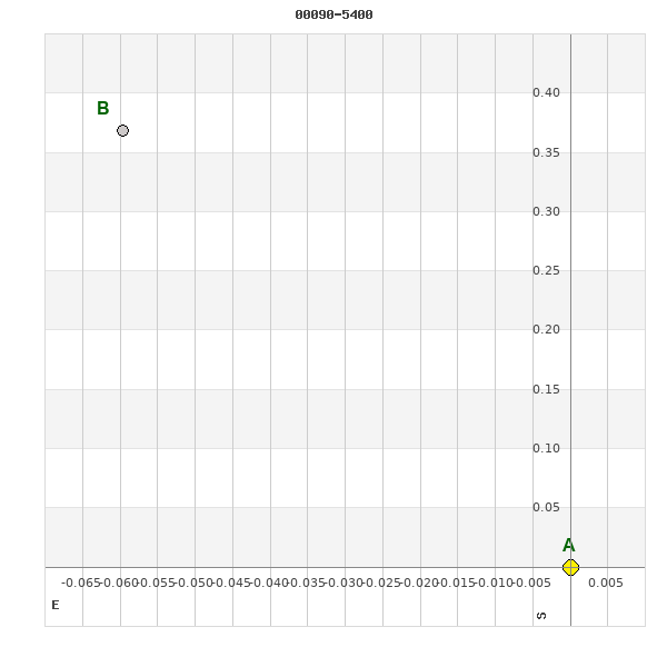
Click on the map to see the double of your interest.
Pass over with the mouse cursor to display the catalog designation.
|
|
WDS 00090-5400 (HD 469) : ALADIN DSS IMAGE @ 00h 09m 02.35s -54° 00' 07.1"
WDS 00090-5400 HDO 181 (HD 469) : NEIGHBORHOODS
|
|
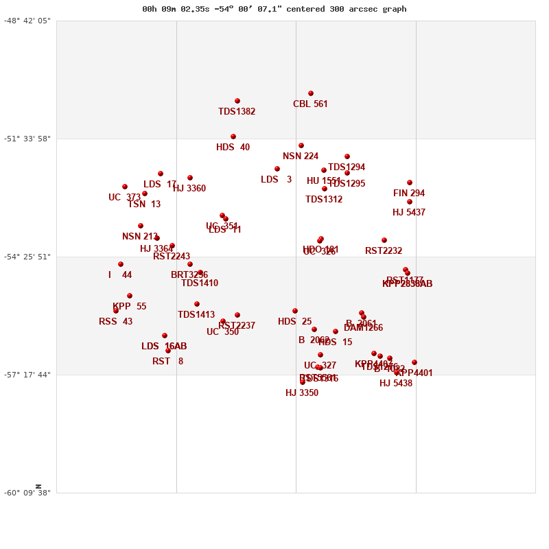
Click on the map to see the double of your interest.
Pass over with the mouse cursor to display the catalog designation.
|
| Show |
name |
coord_2000 |
discov# |
comp |
pa |
sep |
dist(') |
| Show |
|
00090-5400 |
HDO 181 |
|
15 |
0.4 |
|
| Show |
|
00091-5403 |
UC 326 |
|
218 |
10.9 |
4 |
| Show |
|
00030-5402 |
RST2232 |
|
48 |
1.3 |
54 |
| Show |
|
00087-5247 |
TDS1312 |
|
296 |
0.5 |
74 |
| Show |
|
00010-5445 |
RST1177 |
|
257 |
3.1 |
84 |
| Show |
|
00181-5330 |
LDS 11 |
|
76 |
18.6 |
86 |
| Show |
|
00007-5450 |
KPP2838 |
AB |
322 |
3.8 |
88 |
| Show |
|
00007-5450 |
TOI 129 |
AC |
162 |
73.6 |
88 |
| Show |
|
00185-5325 |
UC 351 |
|
223 |
29.0 |
91 |
| Show |
|
00006-5306 |
HJ 5437 |
|
340 |
1.4 |
93 |
| Show |
|
00065-5224 |
TDS1295 |
|
288 |
2.8 |
99 |
| Show |
|
00087-5220 |
HU 1551 |
|
125 |
8.1 |
101 |
| Show |
|
00115-5545 |
HDS 25 |
|
74 |
0.1 |
108 |
| Show |
|
00132-5219 |
LDS 3 |
|
165 |
269.1 |
109 |
| Show |
|
00006-5238 |
FIN 294 |
|
29 |
0.8 |
112 |
| Show |
|
00206-5449 |
TDS1410 |
|
310 |
0.5 |
112 |
| Show |
|
00052-5548 |
B 2061 |
|
2 |
1.3 |
113 |
| Show |
|
00216-5437 |
BRT3256 |
|
43 |
6.1 |
116 |
| Show |
|
00049-5554 |
DAM1266 |
|
209 |
9.5 |
120 |
| Show |
|
00065-5200 |
TDS1294 |
|
224 |
2.3 |
122 |
| Show |
|
00233-5410 |
RST2243 |
|
140 |
1.0 |
126 |
| Show |
|
00171-5551 |
RST2237 |
|
267 |
0.5 |
131 |
| Show |
|
00096-5612 |
B 2062 |
|
11 |
10.7 |
132 |
| Show |
|
00077-5615 |
HDS 15 |
|
70 |
0.1 |
136 |
| Show |
|
00109-5144 |
NSN 224 |
|
321 |
13.8 |
137 |
| Show |
|
00247-5359 |
HJ 3364 |
|
247 |
51.4 |
139 |
| Show |
|
00209-5534 |
TDS1413 |
|
148 |
0.8 |
140 |
| Show |
|
00216-5232 |
HJ 3360 |
|
53 |
17.3 |
144 |
| Show |
|
00184-5600 |
UC 350 |
|
169 |
66.1 |
145 |
| Show |
|
00263-5341 |
NSN 213 |
|
251 |
5.6 |
154 |
| Show |
|
00259-5254 |
TSN 13 |
|
331 |
286.9 |
165 |
| Show |
|
00174-5131 |
HDS 40 |
|
16 |
0.2 |
168 |
| Show |
|
00243-5226 |
LDS 17 |
|
7 |
144.2 |
168 |
| Show |
|
00091-5649 |
UC 327 |
|
182 |
44.5 |
169 |
| Show |
|
00282-5437 |
I 44 |
|
263 |
0.5 |
172 |
| Show |
|
00040-5647 |
KPP4407 |
|
26 |
1.6 |
173 |
| Show |
|
00034-5651 |
TDS1276 |
|
267 |
0.5 |
178 |
| Show |
|
00274-5523 |
KPP 55 |
|
347 |
3.9 |
180 |
| Show |
|
00025-5654 |
B 1022 |
|
127 |
3.0 |
183 |
| Show |
|
00278-5244 |
UC 373 |
|
31 |
20.3 |
185 |
| Show |
|
00094-5707 |
RST5561 |
|
175 |
4.3 |
187 |
| Show |
|
00091-5708 |
TDS1316 |
|
241 |
0.5 |
188 |
| Show |
|
00239-5620 |
LDS 16 |
AB |
57 |
91.8 |
191 |
| Show |
|
00239-5620 |
LDS 16 |
Aa,Ab |
281 |
2.9 |
191 |
| Show |
|
00001-5700 |
KPP4401 |
|
145 |
2.5 |
195 |
| Show |
|
00287-5544 |
RSS 43 |
|
127 |
24.7 |
199 |
| Show |
|
00018-5715 |
HJ 5438 |
|
322 |
11.1 |
204 |
| Show |
|
00237-5643 |
RST 8 |
|
218 |
1.3 |
206 |
| Show |
|
00108-5729 |
HJ 3350 |
|
184 |
3.2 |
210 |
| Show |
|
00100-5028 |
CBL 561 |
|
84 |
21.0 |
213 |
| Show |
|
00171-5039 |
TDS1382 |
|
119 |
2.1 |
215 |
|
|
WDS 00090-5400 : COMPONENTS
00090-5400 A
| Componente originario normalizzato |
AB |
|
Name |
HD 469 |
|
Coord arcsec 2000 |
000902.35-540007.1 |
|
Mag |
6.74 |
|
| Spectral class |
G4IV (yellow) |
|
PmRA |
47.00 |
|
PmDE |
17.0 |
|
SAO |
231943 |
|
| HIP |
730 |
|
Tycho2 |
8464-00766-1 |
|
HD |
469 |
|
HR |
23 |
|
| GC |
148 |
|
CP |
CP-54 19 |
|
| Tycho2 |
8464-00766-1 |
|
Pflag |
|
|
RAmdeg |
2.25997544 |
|
DEmdeg |
-54.00193027 |
|
| PmRA |
46.6 |
|
PmDE |
13.3 |
|
E RAmdeg |
4 |
|
E DEmdeg |
4 |
|
| E pmRA |
0.9 |
|
E pmDE |
0.9 |
|
EpRAm |
1991.13 |
|
EpDEm |
1991.23 |
|
| Num |
14 |
|
Q RAmdeg |
0.8 |
|
Q DEmdeg |
1.2 |
|
Q pmRA |
0.8 |
|
| Q pmDE |
1.1 |
|
BTmag |
7.238 |
|
E BTmag |
0.015 |
|
VTmag |
6.420 |
|
| E VTmag |
0.009 |
|
Prox |
999 |
|
TYC |
T |
|
HIP |
730 |
|
| CCDM |
AB |
|
RAdeg |
2.25979000 |
|
DEdeg |
-54.00196139 |
|
EpRA 1990 |
1.58 |
|
| EpDE 1990 |
1.66 |
|
E RAdeg |
3.6 |
|
E DEdeg |
3.5 |
|
Posflg |
P |
|
| Corr |
0.2 |
|
| SAO |
231943 |
|
DelFlag |
|
|
RA1950 |
|
|
PmRA1950 |
0.006 |
|
| DE1950 |
|
|
PmDE1950 |
0.022 |
|
Vmag |
6.3 |
|
SpType |
G0 |
|
| Double code |
|
|
Source |
70 |
|
CatNum |
148 |
|
DM |
CP-54 19 |
|
| DMcomp |
|
|
BDsup |
|
|
HD |
469 |
|
M HD |
0 |
|
| GC |
148 |
|
RA1950rad |
0.02846947 |
|
DE1950rad |
-0.94737197 |
|
PmRA2000 |
0.0057 |
|
| PmDE2000 |
0.016 |
|
| Catalog |
H |
|
HIP |
730 |
|
Proxy |
H |
|
RAhms |
00 09 02.35 |
|
| DEdms |
-54 00 07.1 |
|
Vmag |
6.32 |
|
VarFlag |
|
|
R Vmag |
G |
|
| RAdeg |
2.25978 |
|
DEdeg |
-54.002 |
|
AstroRef |
* |
|
Plx |
7 |
|
| CCDM |
00090-5400 |
|
N CCDM |
I |
|
Nsys |
1 |
|
Ncomp |
2 |
|
| MultFlag |
C |
|
Source |
|
|
Qual |
A |
|
M HIP |
AB |
|
| Theta |
88 |
|
Rho |
0.239 |
|
HD |
469 |
|
BD |
|
|
| CD |
|
|
CP |
CP-54 19 |
|
Dm number |
-54 19 |
|
VIred |
0.81 |
|
| SpType |
G4IV... |
|
R SpType |
|
|
Coord arcsec 2000 |
000902.35-540007.1 |
|
| HIP |
730 |
|
Sn |
57 |
|
So |
3 |
|
Nc |
2 |
|
| RArad |
0.0394405594 |
|
DErad |
-0.9425120517 |
|
Plx |
7.79 |
|
PmRA |
46.89 |
|
| PmDE |
10.76 |
|
E RArad |
0.53 |
|
E DErad |
0.53 |
|
E Plx |
0.74 |
|
| E pmRA |
0.67 |
|
E pmDE |
0.66 |
|
Hpmag |
6.4622 |
|
E Hpmag |
0.0006 |
|
| SHp |
0.008 |
|
VA |
0 |
|
BV |
0.738 |
|
E BV |
0.008 |
|
| VI |
0.81 |
|
| Ccdm |
00090-5400 |
|
RComp |
|
|
Comp |
A |
|
Note1 |
|
|
| Note2 |
|
|
Discov num |
|
|
DRAs |
2.40 |
|
DDEs |
-6.8 |
|
| R dRAs |
10 |
|
Year |
|
|
Theta |
|
|
Rho |
|
|
| Obs |
2 |
|
Vmag |
6.6 |
|
Sp |
G0 |
|
PmNote |
* |
|
| PmRA |
53 |
|
PmDE |
21 |
|
Dm number |
-54 19 |
|
Cat1 |
CPD |
|
| Name2 |
231943 |
|
Cat2 |
SAO |
|
HD |
469 |
|
M HD |
|
|
| ADS BDS |
|
|
M ADS BDS |
|
|
N IDS |
|
|
IDS |
00040S5433A |
|
| HIC |
730 |
|
00090-5400 B
| Componente originario normalizzato |
AB |
|
Coord arcsec 2000 |
000902.36-540006.7 |
|
Mag |
8.07 |
|
Calc delta mag |
1.33 |
|
| Calc coord |
yes |
|
| Ccdm |
00090-5400 |
|
RComp |
|
|
Comp |
B |
|
Note1 |
|
|
| Note2 |
|
|
Discov num |
HDO 181 |
|
DRAs |
|
|
DDEs |
|
|
| R dRAs |
|
|
Year |
1959 |
|
Theta |
206 |
|
Rho |
0.4 |
|
| Obs |
17 |
|
Vmag |
7.9 |
|
Sp |
|
|
PmNote |
|
|
| PmRA |
|
|
PmDE |
|
|
Dm number |
|
|
Cat1 |
|
|
| Name2 |
|
|
Cat2 |
|
|
HD |
|
|
M HD |
|
|
| ADS BDS |
|
|
M ADS BDS |
|
|
N IDS |
|
|
IDS |
00040S5433B |
|
| HIC |
730 |
|