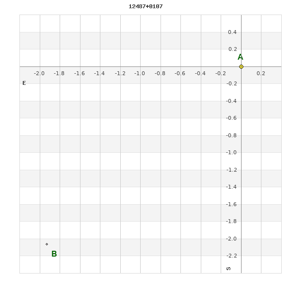
12487+0107 RST 5369
12h 48m 44.35s +01° 07' 29.5" P.A. 137.00 sep 2.8 mag 9.83,13.20 Sp G5III
| Coord 2000 |
12487+0107 |
|
Discov num |
RST5369 |
|
Comp |
|
|
Coord arcsec 2000 |
12 48 44.35 +01 07 29.5 |
|
| Date first |
1946 |
|
Date last |
2016 |
|
Obs |
6 |
|
| Pa first |
139 |
|
Pa last |
136.9 |
|
P.A. Now (θ) |
136.9° |
|
| Sep first |
2.7 |
|
Sep last |
2.828 |
|
Sep. Now (ρ) |
2.828" |
|
| Mag pri |
9.83 |
|
Mag sec |
13.20 |
|
delta mag (ΔM) |
3.37 |
|
Spectral class |
G5III (yellow) |
|
| Pri motion ra |
-040 |
|
Sec motion ra |
-040 |
|
| Pri motion dec |
-051 |
|
Sec motion dec |
-051 |
|
| Notes |
V
(Proper motion indicates physical) |
|
This double is physical.
OTHER CATALOGS AND DESIGNATIONS
| Constellation |
Virgo |
|
Tycho2 |
0290-00692-1 |
|
Gaia DR2 |
3702153167955241472 |
|
WDS 12487+0107 RST 5369 : NOTES
No records found.
REFERENCES
| refcode |
metd |
author |
reference |
| Rst1933 |
T - |
Rossiter, R.A. |
1933MmRAS..65...27R |
| Rst1933 |
|
MemRAS 65, 27, 1933 |
|
| Rst1937 |
Ma - |
Rossiter, R.A. |
1937MmRAS..65...51R |
| Rst1937 |
|
MemRAS 65, 51, 1937 |
|
| Rst1943 |
Ma - |
Rossiter, R.A. |
1943POMic...8..133R |
| Rst1943 |
|
Pub. Univ. Michigan Obs. 8, 133, 1943 |
|
| Rst1944 |
- |
Rossiter, R.A. |
1944POMic...9....1R |
| Rst1944 |
|
Pub. Univ. Michigan Obs. 9, 1, 1944 |
|
| Rst1947 |
Ma - |
Rossiter, R.A. |
1947POMic...9....7R |
| Rst1947 |
|
Pub. Univ. Michigan Obs. 9, 7, 1947 |
|
| Rst1955 |
Ma j |
Rossiter, R.A. |
1955POMic..11....1R |
| Rst1955 |
+P+ |
Pub. Univ. Michigan Obs. 11, 1, 1955 |
|
| Rst1964 |
Ma - |
Rossiter, R.A. |
1964POMic...9...73R |
| Rst1964 |
|
Pub. Univ. Michigan Obs. 9, 73, 1964 |
|
WDS HISTORIC DATA
| coord_2000 |
discov_num |
comp |
epoch |
obs |
pa |
sep |
mag_pri |
mag_sec |
spectr |
notes |
coord_arcsec_2000 |
| 12487+0107 |
RST5369 |
|
1970 |
2 |
138 |
2.6 |
9.83 |
13.20 |
G5III |
|
124844.35+010729.5 |
| 12487+0107 |
RST5369 |
|
2000 |
3 |
138 |
2.9 |
9.83 |
13.20 |
G5III |
|
124844.35+010729.5 |
| 12487+0107 |
RST5369 |
|
2009 |
4 |
137 |
2.9 |
9.83 |
13.20 |
G5III |
|
124844.35+010729.5 |
| 12487+0107 |
RST5369 |
|
2015 |
5 |
137 |
2.8 |
9.83 |
13.20 |
G5III |
|
124844.35+010729.5 |
| 12487+0107 |
RST5369 |
|
2016 |
6 |
137 |
2.8 |
9.83 |
13.20 |
G5III |
|
124844.35+010729.5 |
If you need more information about this double, apply for a
data request form to the WDS.
WDS 12487+0107 RST 5369 : VISUAL OBSERVATIONS REPORTS
No records found.
WDS 12487+0107 RST 5369 : MEASURES
No records found.
WDS 12487+0107 : VIRTUAL EYEPIECE
Click on the map to see the double of your interest.
Pass over with the mouse cursor to display the catalog designation.
|
|
WDS 12487+0107 : ALADIN DSS IMAGE @ 12h 48m 44.35s +01° 07' 29.5"
WDS 12487+0107 RST 5369 : NEIGHBORHOODS
|
|
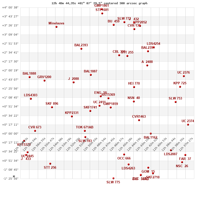
Click on the map to see the double of your interest.
Pass over with the mouse cursor to display the catalog designation.
|
| Show |
name |
coord_2000 |
discov# |
comp |
pa |
sep |
dist(') |
| Show |
|
12487+0107 |
RST5369 |
|
137 |
2.8 |
|
| Show |
|
12497+0111 |
ENG 50 |
|
337 |
197.8 |
16 |
| Show |
|
12484+0050 |
GWP1859 |
|
220 |
47.0 |
19 |
| Show |
|
12499+0053 |
UC 2411 |
|
298 |
48.5 |
23 |
| Show |
|
12460-0059 |
LDS4263 |
|
193 |
12.1 |
41 |
| Show |
|
12467-0040 |
OCC 666 |
|
-1 |
0.1 |
42 |
| Show |
|
12512+0043 |
SKF1741 |
|
47 |
3.8 |
44 |
| Show |
|
12454+0101 |
NSN 40 |
|
333 |
5.8 |
51 |
| Show |
|
12454+0128 |
HEI 770 |
|
168 |
1.8 |
55 |
| Show |
|
12511+0152 |
BAL1887 |
|
52 |
8.2 |
57 |
| Show |
|
12447+0026 |
CVR1463 |
|
64 |
3.8 |
74 |
| Show |
|
12533+0138 |
J 2088 |
|
296 |
7.6 |
76 |
| Show |
|
12518-0007 |
SLW 783 |
|
169 |
37.8 |
77 |
| Show |
|
12518+0005 |
TOK 671 |
AB |
7 |
22.8 |
79 |
| Show |
|
12536+0033 |
KPP2331 |
|
78 |
19.9 |
81 |
| Show |
|
12473+0230 |
CBL 396 |
|
84 |
18.9 |
85 |
| Show |
|
12462+0228 |
STT 255 |
|
354 |
17.8 |
89 |
| Show |
|
12436+0210 |
A 2488 |
|
191 |
4.6 |
99 |
| Show |
|
12432+0000 |
BAL1162 |
|
303 |
15.3 |
108 |
| Show |
|
12523+0242 |
BAL2393 |
|
289 |
18.8 |
109 |
| Show |
|
12562+0050 |
SKF 896 |
|
97 |
5.6 |
114 |
| Show |
|
12564-0057 |
STT 256 |
|
101 |
1.1 |
116 |
| Show |
|
12435+0237 |
BAL2391 |
|
214 |
9.8 |
119 |
| Show |
|
12405-0032 |
LDS2887 |
|
100 |
4.5 |
129 |
| Show |
|
12572+0140 |
GRV1200 |
|
349 |
26.1 |
132 |
| Show |
|
12427+0244 |
LDS4254 |
|
338 |
14.8 |
132 |
| Show |
|
12399+0100 |
SLW 753 |
|
352 |
20.1 |
134 |
| Show |
|
12481+0327 |
BU 459 |
|
294 |
4.4 |
141 |
| Show |
|
12453+0319 |
CVR 130 |
|
240 |
23.0 |
142 |
| Show |
|
12393+0129 |
KPP 725 |
|
297 |
6.4 |
144 |
| Show |
|
12390-0055 |
NSC 26 |
|
40 |
8.8 |
147 |
| Show |
|
12467+0332 |
SLW 772 |
|
170 |
17.4 |
149 |
| Show |
|
12446+0326 |
KPP2052 |
|
238 |
16.4 |
152 |
| Show |
|
12454+0331 |
J 432 |
|
249 |
1.2 |
153 |
| Show |
|
12481-0126 |
SLW 775 |
|
235 |
12.7 |
154 |
| Show |
|
12589+0107 |
LDS4303 |
|
59 |
2.3 |
154 |
| Show |
|
12435-0105 |
GOM 15 |
|
253 |
18.4 |
155 |
| Show |
|
12386-0041 |
FAR 37 |
|
86 |
0.6 |
155 |
| Show |
|
12388+0150 |
UC 2376 |
|
208 |
35.5 |
156 |
| Show |
|
12584+0005 |
CVR 673 |
|
239 |
8.8 |
159 |
| Show |
|
12445-0119 |
ZUC 11 |
BC |
252 |
3.2 |
160 |
| Show |
|
12445-0119 |
SKF 38 |
AB |
337 |
9.5 |
160 |
| Show |
|
12592+0148 |
BAL1888 |
|
193 |
18.5 |
162 |
| Show |
|
12496+0349 |
STF1681 |
|
17 |
9.2 |
163 |
| Show |
|
12594-0036 |
UC 2445 |
|
144 |
49.5 |
164 |
| Show |
|
12595-0040 |
J 433 |
|
156 |
3.6 |
166 |
| Show |
|
12382+0017 |
UC 2374 |
|
337 |
9.3 |
166 |
| Show |
|
12429-0116 |
SKF2710 |
|
246 |
1.4 |
169 |
| Show |
|
12496+0358 |
GWP1861 |
|
290 |
14.0 |
171 |
| Show |
Minelauva |
12556+0324 |
BUP 146 |
|
127 |
192.1 |
171 |
| Show |
|
12599-0014 |
RST5373 |
|
110 |
2.9 |
176 |
|
|
WDS 12487+0107 : COMPONENTS
12487+0107 A
| Componente originario normalizzato |
AB |
|
Coord arcsec 2000 |
124844.35+010729.5 |
|
Mag |
9.83 |
|
Spectral class |
G5III (yellow) |
|
| PmRA |
-40.00 |
|
PmDE |
-51.0 |
|
Tycho2 |
0290-00692-1 |
|
DM |
BD+01 2757 |
|
| Tycho2 |
0290-00692-1 |
|
Pflag |
|
|
RAmdeg |
192.18481673 |
|
DEmdeg |
1.12487281 |
|
| PmRA |
-44.5 |
|
PmDE |
-51.2 |
|
E RAmdeg |
15 |
|
E DEmdeg |
17 |
|
| E pmRA |
1.2 |
|
E pmDE |
1.2 |
|
EpRAm |
1988.42 |
|
EpDEm |
1986.44 |
|
| Num |
10 |
|
Q RAmdeg |
1.1 |
|
Q DEmdeg |
1.4 |
|
Q pmRA |
1.2 |
|
| Q pmDE |
1.3 |
|
BTmag |
10.630 |
|
E BTmag |
0.035 |
|
VTmag |
9.830 |
|
| E VTmag |
0.025 |
|
Prox |
999 |
|
TYC |
T |
|
HIP |
|
|
| CCDM |
|
|
RAdeg |
192.18492028 |
|
DEdeg |
1.12500056 |
|
EpRA 1990 |
1.59 |
|
| EpDE 1990 |
1.47 |
|
E RAdeg |
15.9 |
|
E DEdeg |
19.4 |
|
Posflg |
|
|
| Corr |
0.3 |
|
| Ccdm |
12487+0107 |
|
RComp |
|
|
Comp |
A |
|
Note1 |
|
|
| Note2 |
|
|
Discov num |
|
|
DRAs |
2.38 |
|
DDEs |
29.5 |
|
| R dRAs |
10 |
|
Year |
|
|
Theta |
|
|
Rho |
|
|
| Obs |
2 |
|
Vmag |
9.8 |
|
Sp |
G5 |
|
PmNote |
* |
|
| PmRA |
-34 |
|
PmDE |
-56 |
|
Dm number |
+01 2757 |
|
Cat1 |
BD |
|
| Name2 |
+01 1500 |
|
Cat2 |
AGK2/3 |
|
HD |
|
|
M HD |
|
|
| ADS BDS |
|
|
M ADS BDS |
|
|
N IDS |
|
|
IDS |
12436N0140A |
|
| HIC |
|
|
12487+0107 B
| Componente originario normalizzato |
AB |
|
Coord arcsec 2000 |
124844.48+010727.4 |
|
Mag |
13.2 |
|
PmRA |
-40.00 |
|
| PmDE |
-51.0 |
|
Calc delta mag |
3.37 |
|
Calc coord |
yes |
|
| Ccdm |
12487+0107 |
|
RComp |
|
|
Comp |
B |
|
Note1 |
|
|
| Note2 |
|
|
Discov num |
RST5369 |
|
DRAs |
|
|
DDEs |
|
|
| R dRAs |
|
|
Year |
1946 |
|
Theta |
139 |
|
Rho |
2.7 |
|
| Obs |
1 |
|
Vmag |
13.2 |
|
Sp |
|
|
PmNote |
|
|
| PmRA |
|
|
PmDE |
|
|
Dm number |
|
|
Cat1 |
|
|
| Name2 |
|
|
Cat2 |
|
|
HD |
|
|
M HD |
|
|
| ADS BDS |
|
|
M ADS BDS |
|
|
N IDS |
|
|
IDS |
12436N0140B |
|
| HIC |
|
|