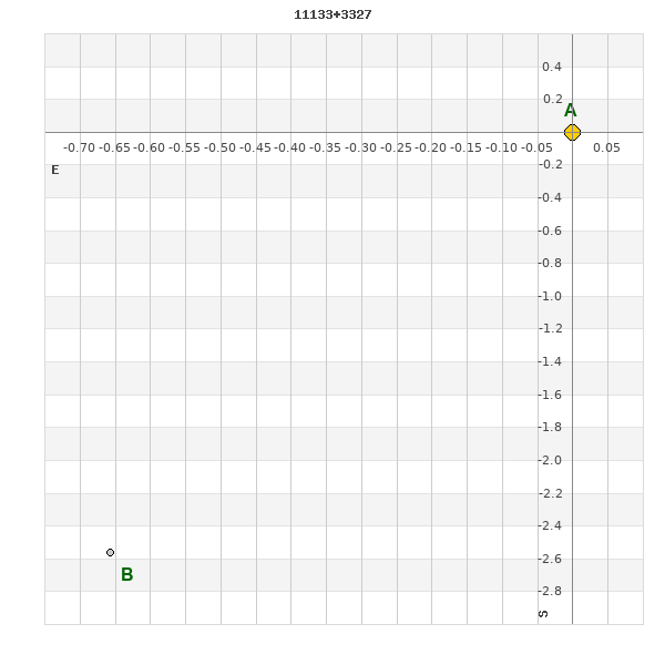
11133+3327 HO 254
11h 13m 19.81s +33° 26' 38.0" P.A. 163.00 sep 2.7 mag 6.80,12.80 Sp K0IV dist. 127.06 pc (414.47 l.y.)
| Coord 2000 |
11133+3327 |
|
Discov num |
HO 254 |
|
Comp |
|
|
Coord arcsec 2000 |
11 13 19.81 +33 26 38.0 |
|
| Date first |
1887 |
|
Date last |
2016 |
|
Obs |
10 |
|
| Pa first |
165 |
|
Pa last |
162.9 |
|
P.A. Now (θ) |
162.9° |
|
| Sep first |
2.3 |
|
Sep last |
2.68 |
|
Sep. Now (ρ) |
2.68" |
|
| Mag pri |
6.80 |
|
Mag sec |
12.80 |
|
delta mag (ΔM) |
6 |
|
Spectral class |
K0IV (yellow-orange) |
|
| Pri motion ra |
-146 |
|
Sec motion ra |
|
|
| Pri motion dec |
-063 |
|
Sec motion dec |
|
|
| Notes |
|
|
Nature of this double is uncertain.
OTHER CATALOGS AND DESIGNATIONS
| Constellation |
Ursa Major |
|
SAO |
62456 |
|
HIP |
54819 |
|
Tycho2 |
2520-01483-1 |
|
| Gaia DR2 |
758383785867118848 |
|
HD |
97488 |
|
GC |
15418 |
|
BD |
BD+34 2206 |
|
| Distance |
127.06 |
|
Distance ly |
414.47 |
|
WDS 11133+3327 HO 254 : NOTES
No records found.
REFERENCES
| refcode |
metd |
author |
reference |
| Ho_1883 |
Ma j |
Hough, G.W. |
1883MNRAS..43..371H |
| Ho_1883 |
|
MNRAS 43, 371, 1883 (data also in Ho_1890) |
1890AN....125....1H |
| Ho_1884 |
Ma j |
Hough, G.W. |
1884MNRAS..44..365H |
| Ho_1884 |
|
MNRAS 44, 365, 1884 (data also in Ho_1890) |
1890AN....125....1H |
| Ho_1885 |
Ma j |
Hough, G.W. |
1885MNRAS..45..417H |
| Ho_1885 |
|
MNRAS 45, 417, 1885 (data also in Ho_1890) |
1890AN....125....1H |
| Ho_1886 |
Ma j |
Hough, G.W. |
1886MNRAS..46..393H |
| Ho_1886 |
|
MNRAS 46, 393, 1886 (data also in Ho_1890) |
1890AN....125....1H |
| Ho_1887 |
Ma j |
Hough, G.W. |
1887AN....116..273H |
| Ho_1887 |
|
AN 116, 273, 1887 |
|
| Ho_1890 |
Ma j |
Hough, G.W. |
1890AN....125....1H |
| Ho_1890 |
|
AN 125, 1, 1890 |
|
| Ho_1890b |
Ma j |
Hough, G.W. |
1890AJ......9..177H |
| Ho_1890b |
|
AJ 9, 177, 1890 (some data also in Ho_1890 or Ho_1894b) |
1890AN....125....1H |
| Ho_1894a |
Ma - |
Hough, G.W. |
1894MNRAS..54..251H |
| Ho_1894a |
|
MNRAS 54, 251, 1894 |
|
| Ho_1894b |
Ma j |
Hough, G.W. (HO 304 - 490) |
1894AN....135..281H |
| Ho_1894b |
|
AN 135, 281, 1894 |
|
| Ho_1894c |
Ma - |
Hough, G.W. (measure by Dembowski, H.) |
1894AN....135..281H |
| Ho_1894c |
|
AN 135, 281, 1894 |
|
| Ho_1899a |
Ma j |
Hough, G.W. |
1899AN....149..65H |
| Ho_1899a |
|
AN 149, 65, 1899 |
|
| Ho_1899b |
Ma - |
Hough, G.W. (measure by Burnham, S.W.) |
1899AN....149..65H |
| Ho_1899b |
|
AN 149, 65, 1899 |
|
| Ho_1907 |
Ma - |
Hough, G.W. |
1907PFAO....3c...1D |
| Ho_1907 |
|
Pub. Univ. Penn. 3, Pt. 3, 1907 (measures sent to Doolittle) |
|
| Ho_1932A |
Ma - |
Hough, G.W. |
1932QB821.A43...... |
| Ho_1932A |
|
cited in ADS, 1932 (unpublished measures sent to Aitken in manuscript by Fox) |
|
WDS HISTORIC DATA
| coord_2000 |
discov_num |
comp |
epoch |
obs |
pa |
sep |
mag_pri |
mag_sec |
spectr |
notes |
coord_arcsec_2000 |
| 11133+3327 |
HO 254 |
|
1925 |
7 |
167 |
2.7 |
6.80 |
12.80 |
K0IV |
|
111319.81+332638.0 |
| 11133+3327 |
HO 254 |
|
2000 |
8 |
175 |
2.7 |
6.80 |
12.80 |
K0IV |
|
111319.81+332638.0 |
| 11133+3327 |
HO 254 |
|
2004 |
8 |
175 |
2.7 |
6.80 |
12.80 |
K0IV |
|
111319.81+332638.0 |
| 11133+3327 |
HO 254 |
|
2016 |
9 |
163 |
2.7 |
6.80 |
12.80 |
K0IV |
|
111319.81+332638.0 |
If you need more information about this double, apply for a
data request form to the WDS.
WDS 11133+3327 HO 254 : VISUAL OBSERVATIONS REPORTS
No records found.
WDS 11133+3327 HO 254 : MEASURES
No records found.
WDS 11133+3327 : VIRTUAL EYEPIECE
Click on the map to see the double of your interest.
Pass over with the mouse cursor to display the catalog designation.
|
|
WDS 11133+3327 : ALADIN DSS IMAGE @ 11h 13m 19.81s +33° 26' 38.0"
WDS 11133+3327 HO 254 : NEIGHBORHOODS
|
|
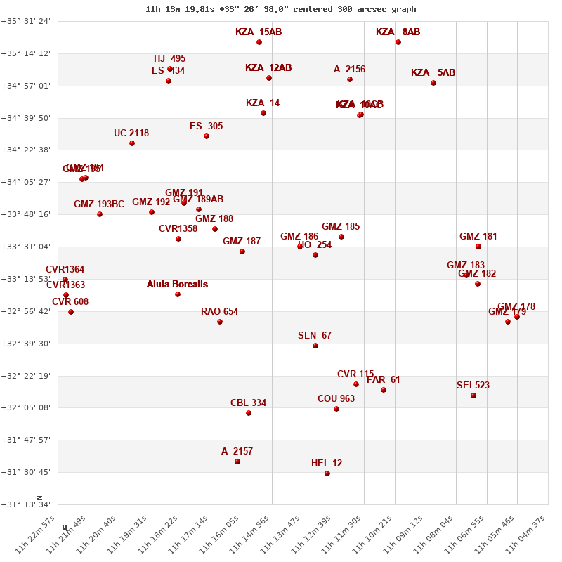
Click on the map to see the double of your interest.
Pass over with the mouse cursor to display the catalog designation.
|
| Show |
name |
coord_2000 |
discov# |
comp |
pa |
sep |
dist(') |
| Show |
|
11133+3327 |
HO 254 |
|
163 |
2.7 |
|
| Show |
|
11139+3331 |
GMZ 186 |
|
195 |
14.6 |
9 |
| Show |
|
11124+3336 |
GMZ 185 |
|
200 |
3.7 |
16 |
| Show |
|
11161+3329 |
GMZ 187 |
|
116 |
4.5 |
35 |
| Show |
|
11133+3238 |
SLN 67 |
|
44 |
56.7 |
49 |
| Show |
|
11171+3340 |
GMZ 188 |
|
75 |
9.0 |
49 |
| Show |
|
11169+3251 |
RAO 654 |
|
270 |
0.8 |
58 |
| Show |
|
11177+3351 |
GMZ 189 |
AB |
102 |
7.3 |
60 |
| Show |
|
11185+3335 |
CVR1358 |
|
337 |
3.5 |
65 |
| Show |
|
11182+3354 |
GMZ 191 |
|
194 |
8.8 |
68 |
| Show |
Alula Borealis |
11185+3306 |
STF1524 |
AB |
147 |
7.0 |
68 |
| Show |
Alula Borealis |
11185+3306 |
BUP9001 |
AC |
147 |
156.8 |
68 |
| Show |
Alula Borealis |
11185+3306 |
DAM 652 |
AD |
269 |
281.1 |
68 |
| Show |
|
11118+3218 |
CVR 115 |
|
139 |
93.9 |
72 |
| Show |
|
11077+3316 |
GMZ 183 |
|
190 |
9.4 |
72 |
| Show |
|
11072+3331 |
GMZ 181 |
|
245 |
24.7 |
77 |
| Show |
|
11117+3441 |
KZA 10 |
AC |
288 |
44.9 |
78 |
| Show |
|
11117+3441 |
KZA 10 |
AB |
43 |
24.5 |
78 |
| Show |
|
11073+3311 |
GMZ 182 |
|
160 |
14.3 |
78 |
| Show |
|
11117+3441 |
KZA 10 |
CB |
86 |
59.7 |
78 |
| Show |
|
11108+3215 |
FAR 61 |
|
298 |
0.2 |
79 |
| Show |
|
11152+3443 |
KZA 14 |
|
334 |
47.6 |
80 |
| Show |
|
11195+3350 |
GMZ 192 |
|
190 |
12.2 |
80 |
| Show |
|
11174+3430 |
ES 305 |
|
32 |
3.9 |
82 |
| Show |
|
11125+3205 |
COU 963 |
|
187 |
1.1 |
83 |
| Show |
|
11158+3202 |
CBL 334 |
|
157 |
38.8 |
91 |
| Show |
|
11120+3500 |
A 2156 |
|
168 |
0.2 |
96 |
| Show |
|
11150+3501 |
KZA 12 |
AB |
21 |
35.0 |
97 |
| Show |
|
11150+3501 |
KZA 12 |
AC |
216 |
43.8 |
97 |
| Show |
|
11150+3501 |
WNO 35 |
AD |
166 |
31.2 |
97 |
| Show |
|
11061+3251 |
GMZ 179 |
|
153 |
20.6 |
98 |
| Show |
|
11058+3254 |
GMZ 178 |
|
263 |
2.8 |
101 |
| Show |
|
11214+3348 |
GMZ 193 |
BC |
352 |
3.7 |
103 |
| Show |
|
11202+3426 |
UC 2118 |
|
68 |
26.8 |
105 |
| Show |
|
11072+3204 |
SEI 523 |
|
78 |
23.3 |
106 |
| Show |
|
11089+3459 |
KZA 5 |
AB |
288 |
51.0 |
107 |
| Show |
|
11089+3459 |
KZA 5 |
AC |
167 |
92.5 |
107 |
| Show |
|
11219+3408 |
GMZ 194 |
|
238 |
10.0 |
115 |
| Show |
|
11188+3458 |
ES 434 |
|
223 |
8.0 |
116 |
| Show |
|
11220+3407 |
GMZ 195 |
|
92 |
2.4 |
116 |
| Show |
|
11162+3136 |
A 2157 |
|
3 |
1.4 |
117 |
| Show |
|
11152+3521 |
KZA 15 |
AB |
138 |
18.8 |
117 |
| Show |
|
11152+3521 |
KZA 15 |
AC |
352 |
18.9 |
117 |
| Show |
|
11129+3130 |
HEI 12 |
|
120 |
2.4 |
117 |
| Show |
|
11227+3313 |
CVR1364 |
|
180 |
3.8 |
118 |
| Show |
|
11225+3256 |
CVR 608 |
|
305 |
8.0 |
119 |
| Show |
|
11227+3305 |
CVR1363 |
|
73 |
3.1 |
119 |
| Show |
|
11102+3520 |
KZA 8 |
AB |
30 |
38.4 |
120 |
| Show |
|
11102+3520 |
KZA 8 |
AC |
341 |
79.8 |
120 |
| Show |
|
11102+3520 |
KZA 8 |
AD |
327 |
85.4 |
120 |
| Show |
|
11194+3506 |
HJ 495 |
|
121 |
14.7 |
121 |
|
|
WDS 11133+3327 : COMPONENTS
11133+3327 A
| Componente originario normalizzato |
AB |
|
Coord arcsec 2000 |
111319.81+332638.0 |
|
Mag |
6.8 |
|
Spectral class |
K0IV (yellow-orange) |
|
| PmRA |
-146.00 |
|
PmDE |
-63.0 |
|
SAO |
62456 |
|
HIP |
54819 |
|
| Tycho2 |
2520-01483-1 |
|
HD |
97488 |
|
GC |
15418 |
|
BD |
BD+34 2206 |
|
| Tycho2 |
2520-01483-1 |
|
Pflag |
|
|
RAmdeg |
168.33213022 |
|
DEmdeg |
33.44374296 |
|
| PmRA |
-145.1 |
|
PmDE |
-63.1 |
|
E RAmdeg |
4 |
|
E DEmdeg |
5 |
|
| E pmRA |
1.0 |
|
E pmDE |
1.1 |
|
EpRAm |
1991.45 |
|
EpDEm |
1991.10 |
|
| Num |
17 |
|
Q RAmdeg |
1.0 |
|
Q DEmdeg |
1.0 |
|
Q pmRA |
1.0 |
|
| Q pmDE |
0.9 |
|
BTmag |
7.951 |
|
E BTmag |
0.016 |
|
VTmag |
6.753 |
|
| E VTmag |
0.010 |
|
Prox |
999 |
|
TYC |
T |
|
HIP |
54819 |
|
| CCDM |
|
|
RAdeg |
168.33252694 |
|
DEdeg |
33.44389111 |
|
EpRA 1990 |
1.78 |
|
| EpDE 1990 |
1.55 |
|
E RAdeg |
4.2 |
|
E DEdeg |
4.6 |
|
Posflg |
|
|
| Corr |
0.2 |
|
| SAO |
62456 |
|
DelFlag |
|
|
RA1950 |
|
|
PmRA1950 |
-0.0116 |
|
| DE1950 |
|
|
PmDE1950 |
-0.06 |
|
Vmag |
6.8 |
|
SpType |
K0 |
|
| Double code |
|
|
Source |
70 |
|
CatNum |
15418 |
|
DM |
BD+34 2206 |
|
| DMcomp |
|
|
BDsup |
|
|
HD |
97488 |
|
M HD |
0 |
|
| GC |
15418 |
|
RA1950rad |
2.92614096 |
|
DE1950rad |
0.58847265 |
|
PmRA2000 |
-0.0115 |
|
| PmDE2000 |
-0.055 |
|
| Catalog |
H |
|
HIP |
54819 |
|
Proxy |
|
|
RAhms |
11 13 19.81 |
|
| DEdms |
+33 26 38.0 |
|
Vmag |
6.62 |
|
VarFlag |
|
|
R Vmag |
H |
|
| RAdeg |
168.333 |
|
DEdeg |
33.4439 |
|
AstroRef |
|
|
Plx |
7.2 |
|
| CCDM |
11133+3327 |
|
N CCDM |
I |
|
Nsys |
1 |
|
Ncomp |
1 |
|
| MultFlag |
|
|
Source |
|
|
Qual |
|
|
M HIP |
|
|
| Theta |
|
|
Rho |
|
|
HD |
97488 |
|
BD |
BD+34 2206 |
|
| CD |
|
|
CP |
|
|
Dm number |
+34 2206 |
|
VIred |
0.99 |
|
| SpType |
K0 |
|
R SpType |
|
|
Coord arcsec 2000 |
111319.81+332638.0 |
|
| HIP |
54819 |
|
Sn |
5 |
|
So |
0 |
|
Nc |
1 |
|
| RArad |
2.9379572984 |
|
DErad |
0.5837060904 |
|
Plx |
7.87 |
|
PmRA |
-144.93 |
|
| PmDE |
-62.93 |
|
E RArad |
0.39 |
|
E DErad |
0.27 |
|
E Plx |
0.41 |
|
| E pmRA |
0.45 |
|
E pmDE |
0.35 |
|
Hpmag |
6.782 |
|
E Hpmag |
0.0009 |
|
| SHp |
0.007 |
|
VA |
0 |
|
BV |
1.007 |
|
E BV |
0.008 |
|
| VI |
0.98 |
|
| Ccdm |
11133+3327 |
|
RComp |
|
|
Comp |
A |
|
Note1 |
|
|
| Note2 |
|
|
Discov num |
|
|
DRAs |
1.68 |
|
DDEs |
-22.6 |
|
| R dRAs |
10 |
|
Year |
|
|
Theta |
|
|
Rho |
|
|
| Obs |
2 |
|
Vmag |
6.8 |
|
Sp |
K0 |
|
PmNote |
* |
|
| PmRA |
-149 |
|
PmDE |
-68 |
|
Dm number |
+34 2206 |
|
Cat1 |
BD |
|
| Name2 |
+33 1068 |
|
Cat2 |
AGK2/3 |
|
HD |
97488 |
|
M HD |
|
|
| ADS BDS |
A 8091 |
|
M ADS BDS |
|
|
N IDS |
|
|
IDS |
11079N3359A |
|
| HIC |
54819 |
|
11133+3327 B
| Componente originario normalizzato |
AB |
|
Coord arcsec 2000 |
111319.86+332635.4 |
|
Mag |
12.8 |
|
Calc delta mag |
6 |
|
| Calc coord |
yes |
|
| Ccdm |
11133+3327 |
|
RComp |
|
|
Comp |
B |
|
Note1 |
|
|
| Note2 |
|
|
Discov num |
HO 254 |
|
DRAs |
|
|
DDEs |
|
|
| R dRAs |
|
|
Year |
1887 |
|
Theta |
163 |
|
Rho |
2.5 |
|
| Obs |
6 |
|
Vmag |
12.8 |
|
Sp |
|
|
PmNote |
|
|
| PmRA |
|
|
PmDE |
|
|
Dm number |
|
|
Cat1 |
|
|
| Name2 |
|
|
Cat2 |
|
|
HD |
|
|
M HD |
|
|
| ADS BDS |
A 8091 |
|
M ADS BDS |
|
|
N IDS |
|
|
IDS |
11079N3359B |
|
| HIC |
54819 |
|