10585-1831 ALD 44
10h 58m 29.84s -18° 31' 36.0" P.A. 301.00 sep 3.4 mag 11.00,12.00
| Coord 2000 |
10585-1831 |
|
Discov num |
ALD 44 |
|
Comp |
|
|
Coord arcsec 2000 |
10 58 29.84 -18 31 36.0 |
|
| Date first |
1927 |
|
Date last |
2016 |
|
Obs |
5 |
|
| Pa first |
301 |
|
Pa last |
301.2 |
|
P.A. Now (θ) |
301.2° |
|
| Sep first |
3.2 |
|
Sep last |
3.431 |
|
Sep. Now (ρ) |
3.431" |
|
| Mag pri |
11.00 |
|
Mag sec |
12.00 |
|
delta mag (ΔM) |
1 |
|
Spectral class |
|
|
| Pri motion ra |
-058 |
|
Sec motion ra |
|
|
| Pri motion dec |
-003 |
|
Sec motion dec |
|
|
| Notes |
|
|
Nature of this double is uncertain.
OTHER CATALOGS AND DESIGNATIONS
| Constellation |
Crater |
|
Tycho2 |
6079-01050-1 |
|
Gaia DR2 |
3552756063459255808 |
|
WDS 10585-1831 ALD 44 : NOTES
No records found.
REFERENCES
| refcode |
metd |
author |
reference |
| Ald1924 |
Po - |
Alden, H.L. |
1924AJ.....35..167A |
| Ald1924 |
|
AJ 35, 167, 1924 |
|
| Ald1925 |
orb - |
Alden, H.L. |
1925AJ.....36...81A |
| Ald1925 |
|
AJ 36, 81, 1925 |
|
| Ald1928 |
Po j |
Alden, H.L. |
1928AJ.....39...20A |
| Ald1928 |
|
AJ 39, 20, 1928 |
|
| Ald1929 |
Po - |
Alden, H.L. |
1929AJ.....39..154A |
| Ald1929 |
|
AJ 39, 154, 1929 |
|
| Ald1931 |
Po - |
Alden, H.L. |
1931AJ.....41...52A |
| Ald1931 |
|
AJ 41, 52, 1931 |
|
| Ald1932A |
- |
Alden, H.L. |
1932QB821.A43...... |
| Ald1932A |
|
cited in ADS (Aitken Double Star Cat.), 1932 |
|
| Ald1935 |
- |
Alden, H.L. |
1935AJ.....44..191A |
| Ald1935 |
|
AJ 44, 191, 1935 |
|
| Ald1936a |
Po - |
Alden, H.L. |
1936AJ.....45...73A |
| Ald1936a |
|
AJ 45, 73, 1936 |
|
| Ald1936b |
orb - |
Alden, H.L. |
1936AJ.....45...82A |
| Ald1936b |
|
AJ 45, 82, 1936 |
|
| Ald1936c |
orb - |
Alden, H.L. |
1936AJ.....45..113A |
| Ald1936c |
|
AJ 45, 113, 1936 |
|
| Ald1938a |
orb - |
Alden, H.L. |
1938AJ.....46..189A |
| Ald1938a |
|
AJ 46, 189, 1938 |
|
| Ald1938b |
orb - |
Alden, H.L. |
1938AJ.....47....9A |
| Ald1938b |
|
AJ 47, 9, 1938 |
|
| Ald1939a |
orb - |
Alden, H.L. |
1939AJ.....47..185A |
| Ald1939a |
|
AJ 47, 185, 1939 |
|
| Ald1939b |
orb - |
Alden, H.L. |
1939AJ.....48...81A |
| Ald1939b |
|
AJ 48, 81, 1939 |
|
| Ald1942 |
orb - |
Alden, H.L. |
1942AJ.....50...73A |
| Ald1942 |
|
AJ 50, 73, 1942 |
|
| Ald1943 |
Po - |
Alden, H.L. |
1943AJ.....50..139A |
| Ald1943 |
|
AJ 50, 139, 1943 |
|
| Ald1945 |
Po - |
Alden, H.L. |
1945AJ.....51..195A |
| Ald1945 |
|
AJ 51, 195, 1945 |
|
| Ald1946 |
orb - |
Alden, H.L. |
1946AJ.....52...73A |
| Ald1946 |
|
AJ 52, 73, 1946 |
|
| Ald1951 |
orb - |
Alden, H.L. |
1951AJ.....56...34A |
| Ald1951 |
|
AJ 56, 34, 1951 |
|
| Ald1957 |
Po - |
Alden, H.L. |
1957AJ.....62Q.276A |
| Ald1957 |
|
AJ 62, 276, 1957 |
|
| Ald9999 |
Po - |
Alden, H.L. |
................... |
| Ald9999 |
|
Unpublished, manuscript or reference not found. |
|
WDS HISTORIC DATA
| coord_2000 |
discov_num |
comp |
epoch |
obs |
pa |
sep |
mag_pri |
mag_sec |
spectr |
notes |
coord_arcsec_2000 |
| 10585-1831 |
ALD 44 |
|
2003 |
2 |
300 |
3.7 |
11.00 |
12.00 |
|
|
105829.84-183136.0 |
| 10585-1831 |
ALD 44 |
|
2015 |
3 |
301 |
3.4 |
11.00 |
12.00 |
|
|
105829.84-183136.0 |
| 10585-1831 |
ALD 44 |
|
2016 |
5 |
301 |
3.4 |
11.00 |
12.00 |
|
|
105829.84-183136.0 |
If you need more information about this double, apply for a
data request form to the WDS.
WDS 10585-1831 ALD 44 : VISUAL OBSERVATIONS REPORTS
No records found.
WDS 10585-1831 ALD 44 : MEASURES
No records found.
WDS 10585-1831 : VIRTUAL EYEPIECE
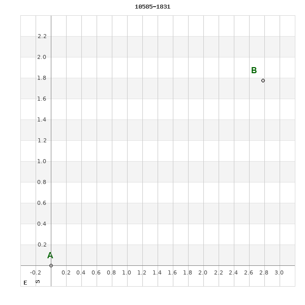
Click on the map to see the double of your interest.
Pass over with the mouse cursor to display the catalog designation.
|
|
WDS 10585-1831 : ALADIN DSS IMAGE @ 10h 58m 29.84s -18° 31' 36.0"
WDS 10585-1831 ALD 44 : NEIGHBORHOODS
|
|
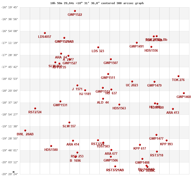
Click on the map to see the double of your interest.
Pass over with the mouse cursor to display the catalog designation.
|
| Show |
name |
coord_2000 |
discov# |
comp |
pa |
sep |
dist(') |
| Show |
|
10585-1831 |
ALD 44 |
|
301 |
3.4 |
1 |
| Show |
|
10585-1816 |
GWP1512 |
|
339 |
46.5 |
16 |
| Show |
|
10575-1818 |
HU 637 |
|
66 |
5.1 |
20 |
| Show |
|
10566-1840 |
HDS1563 |
|
215 |
1.2 |
28 |
| Show |
|
11006-1819 |
HJ 1181 |
|
268 |
63.1 |
32 |
| Show |
|
10579-1756 |
GWP1511 |
|
25 |
60.5 |
37 |
| Show |
|
11015-1812 |
J 1571 |
|
229 |
6.1 |
47 |
| Show |
|
10551-1807 |
UC 2023 |
|
309 |
57.5 |
54 |
| Show |
|
10576-1735 |
GWP1507 |
|
121 |
8.4 |
59 |
| Show |
|
10591-1931 |
RST3722 |
|
273 |
0.3 |
61 |
| Show |
|
10585-1935 |
TDS7583 |
|
246 |
0.8 |
64 |
| Show |
|
11024-1906 |
SLW 557 |
|
252 |
116.2 |
65 |
| Show |
|
11034-1836 |
GWP1531 |
|
43 |
51.9 |
70 |
| Show |
|
10590-1717 |
LDS 323 |
|
63 |
21.8 |
75 |
| Show |
|
10576-1945 |
ARA 677 |
|
32 |
15.1 |
76 |
| Show |
|
11019-1932 |
ARA 414 |
|
197 |
16.5 |
78 |
| Show |
|
11023-1735 |
GWP1527 |
|
89 |
99.5 |
79 |
| Show |
|
11025-1730 |
A 2377 |
|
105 |
3.7 |
84 |
| Show |
|
10576-1955 |
GWP1506 |
|
328 |
40.6 |
85 |
| Show |
|
10525-1838 |
HU 460 |
|
10 |
0.6 |
86 |
| Show |
|
10526-1807 |
GWP1479 |
|
334 |
31.4 |
88 |
| Show |
|
11035-1741 |
KPP2735 |
|
119 |
6.7 |
88 |
| Show |
|
11015-1949 |
RSS 253 |
|
|
17.0 |
89 |
| Show |
|
10522-1839 |
TDS7520 |
|
295 |
0.7 |
90 |
| Show |
|
10543-1938 |
KPP 617 |
|
275 |
5.6 |
90 |
| Show |
|
11040-1739 |
SLW 562 |
|
118 |
118.0 |
95 |
| Show |
|
11033-1726 |
ARA 64 |
|
306 |
6.8 |
95 |
| Show |
|
11017-1955 |
B 1696 |
|
4 |
1.9 |
96 |
| Show |
|
10546-1711 |
GWP1491 |
|
252 |
38.2 |
99 |
| Show |
|
10571-2009 |
RST3721 |
AB |
344 |
0.7 |
100 |
| Show |
|
10571-2009 |
ARA 676 |
AC |
53 |
12.0 |
100 |
| Show |
|
10524-1924 |
GWP1477 |
|
206 |
49.6 |
102 |
| Show |
|
10540-1958 |
GWP1488 |
|
250 |
93.5 |
108 |
| Show |
|
11029-1704 |
GWP1529 |
AB |
23 |
41.5 |
109 |
| Show |
|
11029-1704 |
GWP1530 |
AC |
277 |
118.4 |
109 |
| Show |
|
11045-1940 |
HDS1580 |
|
285 |
17.5 |
109 |
| Show |
|
10529-1717 |
HDS1556 |
|
288 |
0.2 |
110 |
| Show |
|
11063-1845 |
RST2724 |
|
66 |
0.6 |
112 |
| Show |
|
10505-1847 |
ARA 413 |
|
132 |
12.7 |
116 |
| Show |
|
10523-1948 |
RST3718 |
|
260 |
1.7 |
117 |
| Show |
|
10535-2008 |
BU 1429 |
AB |
222 |
119.6 |
120 |
| Show |
|
10512-1932 |
KPP 993 |
|
48 |
8.0 |
121 |
| Show |
|
10535-2008 |
HO 533 |
BC |
132 |
13.7 |
122 |
| Show |
|
10535-2008 |
HO 533 |
BD |
297 |
40.5 |
122 |
| Show |
|
10527-1702 |
TOK 277 |
AB |
274 |
279.1 |
123 |
| Show |
|
10527-1702 |
TOK 277 |
Ba,Bb |
340 |
0.2 |
127 |
| Show |
|
10498-1759 |
TOK 276 |
|
222 |
67.7 |
128 |
| Show |
|
10492-1823 |
GWP1468 |
|
251 |
32.0 |
133 |
| Show |
|
11052-1656 |
LDS4057 |
|
346 |
8.9 |
135 |
| Show |
|
11017-1625 |
GWP1522 |
|
176 |
10.1 |
135 |
| Show |
|
11075-1917 |
BWL 28 |
AB |
43 |
9.9 |
136 |
|
|
WDS 10585-1831 : COMPONENTS
10585-1831 A
| Componente originario normalizzato |
AB |
|
Coord arcsec 2000 |
105829.84-183136.0 |
|
Mag |
11 |
|
PmRA |
-58.00 |
|
| PmDE |
-3.0 |
|
Tycho2 |
6079-01050-1 |
|
| Tycho2 |
6079-01050-1 |
|
Pflag |
|
|
RAmdeg |
164.62435078 |
|
DEmdeg |
-18.52667268 |
|
| PmRA |
-58.0 |
|
PmDE |
-3.1 |
|
E RAmdeg |
52 |
|
E DEmdeg |
71 |
|
| E pmRA |
2.3 |
|
E pmDE |
2.5 |
|
EpRAm |
1983.94 |
|
EpDEm |
1978.45 |
|
| Num |
4 |
|
Q RAmdeg |
0.7 |
|
Q DEmdeg |
1.5 |
|
Q pmRA |
0.7 |
|
| Q pmDE |
1.5 |
|
BTmag |
11.724 |
|
E BTmag |
0.104 |
|
VTmag |
11.150 |
|
| E VTmag |
0.103 |
|
Prox |
999 |
|
TYC |
T |
|
HIP |
|
|
| CCDM |
|
|
RAdeg |
164.62449250 |
|
DEdeg |
-18.52666556 |
|
EpRA 1990 |
1.68 |
|
| EpDE 1990 |
1.61 |
|
E RAdeg |
54.9 |
|
E DEdeg |
77.9 |
|
Posflg |
|
|
| Corr |
0.1 |
|
10585-1831 B
| Componente originario normalizzato |
AB |
|
Coord arcsec 2000 |
105829.64-183134.2 |
|
Mag |
12 |
|
Calc delta mag |
1 |
|
| Calc coord |
yes |
|