01131+2942 A 1260 AB
01h 13m 08.90s +29° 41' 59.1" P.A. 63.00 sep 0.2 mag 9.19,9.40 Sp G0
| Coord 2000 |
01131+2942 |
|
Discov num |
A 1260 |
|
Comp |
AB |
|
Coord arcsec 2000 |
01 13 08.90 +29 41 59.1 |
|
| Date first |
1905 |
|
Date last |
2014 |
|
Obs |
26 |
|
| Pa first |
255 |
|
Pa last |
63 |
|
P.A. Now (θ) |
73° |
|
| Sep first |
0.2 |
|
Sep last |
0.223 |
|
Sep. Now (ρ) |
0.125" |
|
| Mag pri |
9.19 |
|
Mag sec |
9.40 |
|
delta mag (ΔM) |
0.21 |
|
Spectral class |
G0 (yellow) |
|
| Pri motion ra |
-018 |
|
Sec motion ra |
|
|
| Pri motion dec |
-030 |
|
Sec motion dec |
|
|
| Notes |
N
O
(See Notes, Orbital solution) |
|
This double is physical.
01131+2942 SYSTEM COMPONENTS
| Show |
name |
SAO |
coord |
wds_name |
last |
obs |
pa |
sep |
mag1 |
mag2 |
d_mag |
orb |
current |
| Show |
|
74562 |
01 13 09 +29 41 59 |
A 1260 AB |
2014 |
26 |
63 |
0.2 |
9.19 |
9.40 |
0.21 |
Y |
<=== |
| Show |
HD 7255 |
74562 |
01 13 09 +29 41 59 |
GRV 76 AC |
2015 |
10 |
170 |
61.6 |
9.19 |
11.00 |
1.81 |
|
|
Triple system
3 estimated visually detectable stars in this system
OTHER CATALOGS AND DESIGNATIONS
| Constellation |
Pisces |
|
SAO |
74562 |
|
Tycho2 |
1753-00396-1 |
|
Gaia DR2 |
309754626231138560 |
|
| HD |
7255 |
|
ADS |
993 |
|
ORBITAL ELEMENTS
| Period (P) | 137.17y | |
Periastron (T) | 2029.43y | |
Semi-major axis (a) | 0.288a | |
| Eccentricity (e) | 0.489 | |
Inclination (i) | 78.1° | |
Longitude of periastron (ω) | 274.29° | |
| Node (Ω) | 242.2° | |
Notes | n | |
Reference | Msn2017a | |
| Equinox | 2000 | |
Last observation | 2009 | |
Grade | 3 | (1=Definitive, 9=Indet.) |
| label |
theta |
rho |
| 2000 |
53.4 |
0.262 |
| 2001 |
54.0 |
0.263 |
| 2002 |
54.6 |
0.263 |
| 2003 |
55.1 |
0.264 |
| 2004 |
55.7 |
0.264 |
| 2005 |
56.3 |
0.263 |
| 2006 |
56.8 |
0.262 |
| 2007 |
57.4 |
0.260 |
| 2008 |
58.0 |
0.258 |
| 2009 |
58.6 |
0.255 |
| 2010 |
59.2 |
0.252 |
| 2011 |
59.8 |
0.248 |
| 2012 |
60.5 |
0.243 |
| 2013 |
61.1 |
0.237 |
| 2014 |
61.8 |
0.231 |
| 2015 |
62.6 |
0.223 |
| 2016 |
63.4 |
0.215 |
| 2017 |
64.3 |
0.206 |
| 2018 |
65.3 |
0.195 |
| 2019 |
66.4 |
0.184 |
| 2020 |
67.6 |
0.171 |
| 2021 |
69.1 |
0.157 |
| 2022 |
70.8 |
0.142 |
| 2023 |
73.0 |
0.125 |
| 2024 |
75.9 |
0.108 |
| 2025 |
80.0 |
0.090 |
| 2026 |
86.1 |
0.071 |
| 2027 |
96.7 |
0.052 |
| 2028 |
117.3 |
0.037 |
| 2029 |
154.7 |
0.030 |
| 2030 |
190.6 |
0.038 |
|
|
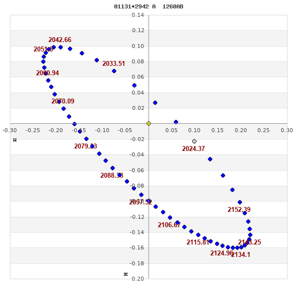
Note: Theta is PA, Rho is Sep. For yearly orbits, data refer to Jan 1st.
|
|
|
|
|
|
|
|
Measures: green=micrometric, blue=interferometric, purple=photographic |
|
WDS 01131+2942 A 1260 AB : NOTES
| discov_num |
notes |
refcode |
| A 1260 |
Angle increasing, with a probable close approach about 1950. |
|
REFERENCES
| refcode |
metd |
author |
reference |
| Msn2017a |
orb - |
Miles, K.N. & Mason, B.D. |
2017IAUDS.191....1M |
| Msn2017a |
|
Inf. Circ. 191, 1, 2017 |
|
DISCOVERER
| idgroup |
discov |
author |
| 1 |
A |
Aitken, R.G. |
| 312 |
GRV |
Greaves, J. |
WDS HISTORIC DATA
| coord_2000 |
discov_num |
comp |
epoch |
obs |
pa |
sep |
mag_pri |
mag_sec |
spectr |
notes |
coord_arcsec_2000 |
| 01131+2942 |
A 1260 |
AB |
1995 |
20 |
49 |
0.2 |
9.60 |
9.80 |
G0 |
NO |
011308.90+294159.1 |
| 01131+2942 |
A 1260 |
AB |
2007 |
21 |
54 |
0.3 |
9.60 |
9.80 |
G0 |
NO |
011308.90+294159.1 |
| 01131+2942 |
A 1260 |
AB |
2009 |
22 |
60 |
0.3 |
9.19 |
9.40 |
G0 |
NO |
011308.90+294159.1 |
| 01131+2942 |
A 1260 |
AB |
2011 |
25 |
51 |
0.2 |
9.19 |
9.40 |
G0 |
NO |
011308.90+294159.1 |
| 01131+2942 |
A 1260 |
AB |
2014 |
26 |
63 |
0.2 |
9.19 |
9.40 |
G0 |
NO |
011308.90+294159.1 |
If you need more information about this double, apply for a
data request form to the WDS.
WDS 01131+2942 A 1260 AB : VISUAL OBSERVATIONS REPORTS
No records found.
WDS 01131+2942 A 1260 AB : MEASURES
No records found.
WDS 01131+2942 : VIRTUAL EYEPIECE
Click on the map to see the double of your interest.
Pass over with the mouse cursor to display the catalog designation.
|
|
WDS 01131+2942 : ALADIN DSS IMAGE @ 01h 13m 08.90s +29° 41' 59.1"
WDS 01131+2942 A 1260 AB : NEIGHBORHOODS
|
|
Click on the map to see the double of your interest.
Pass over with the mouse cursor to display the catalog designation.
|
| Show |
name |
coord_2000 |
discov# |
comp |
pa |
sep |
dist(') |
| Show |
|
01131+2942 |
A 1260 |
AB |
63 |
0.2 |
1 |
| Show |
|
01131+2942 |
GRV 76 |
AC |
170 |
61.6 |
1 |
| Show |
|
01129+2953 |
LDS1088 |
|
114 |
40.9 |
12 |
| Show |
|
01116+2939 |
LDS3240 |
|
248 |
33.8 |
22 |
| Show |
|
01130+3004 |
STT 26 |
AB |
258 |
10.7 |
22 |
| Show |
|
01130+3004 |
STT 26 |
AC |
341 |
117.7 |
22 |
| Show |
|
01141+3010 |
LDS1089 |
|
286 |
7.0 |
30 |
| Show |
|
01104+2952 |
BU 2 |
|
153 |
2.1 |
38 |
| Show |
|
01097+2931 |
RAO 528 |
Aa,Ab |
125 |
0.6 |
47 |
| Show |
|
01094+2949 |
ALP 4 |
|
141 |
40.4 |
50 |
| Show |
|
01143+3033 |
HJ 636 |
|
288 |
20.4 |
53 |
| Show |
|
01177+3017 |
SLW 59 |
|
296 |
10.1 |
69 |
| Show |
|
01088+3024 |
HDS 149 |
|
186 |
0.4 |
71 |
| Show |
|
01134+3057 |
ES 2547 |
AB |
101 |
8.6 |
75 |
| Show |
|
01136+2825 |
HJ 635 |
|
127 |
15.0 |
80 |
| Show |
|
01116+2823 |
FMR 5 |
|
294 |
4.7 |
82 |
| Show |
|
01070+3014 |
CHR 142 |
Aa,Ab |
114 |
0.1 |
86 |
| Show |
|
01070+3014 |
A 929 |
AB |
128 |
0.7 |
86 |
| Show |
|
01135+2814 |
GRV 78 |
|
133 |
24.3 |
88 |
| Show |
|
01181+3042 |
CVR 378 |
|
38 |
7.1 |
89 |
| Show |
|
01151+3112 |
A 1261 |
|
320 |
0.6 |
93 |
| Show |
|
01056+2952 |
WIS 21 |
|
280 |
899.4 |
99 |
| Show |
|
01146+2804 |
A 1904 |
|
71 |
1.2 |
100 |
| Show |
|
01205+3014 |
LDS1095 |
|
3 |
113.2 |
101 |
| Show |
|
01188+2831 |
MLB 556 |
|
290 |
3.4 |
103 |
| Show |
|
01164+2809 |
LDS1090 |
|
172 |
2.8 |
104 |
| Show |
|
01151+3125 |
WFC 248 |
|
8 |
10.7 |
106 |
| Show |
|
01111+3125 |
STT 25 |
|
-1 |
-1.0 |
107 |
| Show |
|
01072+2828 |
CVR 367 |
|
89 |
17.7 |
108 |
| Show |
|
01214+2926 |
JNN 15 |
|
310 |
0.3 |
110 |
| Show |
|
01065+2834 |
VKI 2 |
|
187 |
2.1 |
110 |
| Show |
|
01089+3117 |
GRV 72 |
|
316 |
44.6 |
110 |
| Show |
|
01096+2802 |
BRT 123 |
|
160 |
4.3 |
111 |
| Show |
|
01195+3106 |
LDS1094 |
|
165 |
2.9 |
117 |
| Show |
|
01210+3042 |
MLB 678 |
|
151 |
1.7 |
118 |
| Show |
|
01069+3109 |
GUR 33 |
|
147 |
0.2 |
119 |
| Show |
|
01143+3140 |
WIS 23 |
|
327 |
999.9 |
119 |
| Show |
|
01085+3127 |
KPP1037 |
|
225 |
8.3 |
122 |
| Show |
|
01042+3019 |
DAM 867 |
AB |
353 |
2.6 |
123 |
| Show |
|
01042+3019 |
DAM 867 |
AC |
141 |
10.6 |
123 |
| Show |
|
01225+2949 |
MLB 445 |
|
355 |
6.8 |
123 |
| Show |
|
01149+2739 |
J 1806 |
BC |
189 |
4.3 |
126 |
| Show |
|
01149+2739 |
J 1806 |
AB |
304 |
73.5 |
126 |
| Show |
|
01165+2743 |
GRV 79 |
|
78 |
24.1 |
127 |
| Show |
|
01083+2753 |
SKF 208 |
AB |
140 |
3.3 |
127 |
| Show |
|
01083+2753 |
HEB 1 |
AC |
128 |
4.6 |
127 |
| Show |
|
01174+2746 |
CVR 376 |
|
27 |
10.3 |
129 |
| Show |
|
01038+3042 |
MLB 597 |
|
95 |
3.0 |
136 |
| Show |
|
01038+3044 |
DAM 866 |
AB |
217 |
136.2 |
137 |
| Show |
|
01038+3044 |
DAM 866 |
AC |
148 |
169.7 |
137 |
| Show |
|
01049+2800 |
MLB 677 |
|
214 |
8.8 |
140 |
|
|
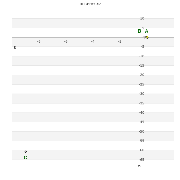
WDS 01131+2942 : COMPONENTS
| |
A |
B |
| B |
pa=59.6°
sep=0.20"
| |
| C |
pa=171.6°
sep=61.35"
| pa=171.7°
sep=61.42"
|
01131+2942 A
| Coord arcsec 2000 |
011308.90+294159.1 |
|
Mag |
9.19 |
|
Spectral class |
G0 (yellow) |
|
PmRA |
-18.00 |
|
| PmDE |
-30.0 |
|
SAO |
74562 |
|
Tycho2 |
1753-00396-1 |
|
HD |
7255 |
|
| DM |
BD+28 202 |
|
| Tycho2 |
1753-00396-1 |
|
Pflag |
|
|
RAmdeg |
18.28709905 |
|
DEmdeg |
29.69975033 |
|
| PmRA |
-29.7 |
|
PmDE |
-21.1 |
|
E RAmdeg |
12 |
|
E DEmdeg |
13 |
|
| E pmRA |
1.3 |
|
E pmDE |
1.2 |
|
EpRAm |
1989.59 |
|
EpDEm |
1988.99 |
|
| Num |
9 |
|
Q RAmdeg |
1.6 |
|
Q DEmdeg |
0.7 |
|
Q pmRA |
1.5 |
|
| Q pmDE |
0.7 |
|
BTmag |
9.651 |
|
E BTmag |
0.026 |
|
VTmag |
9.187 |
|
| E VTmag |
0.022 |
|
Prox |
615 |
|
TYC |
T |
|
HIP |
|
|
| CCDM |
|
|
RAdeg |
18.28717778 |
|
DEdeg |
29.69980083 |
|
EpRA 1990 |
1.61 |
|
| EpDE 1990 |
1.59 |
|
E RAdeg |
13.2 |
|
E DEdeg |
14.0 |
|
Posflg |
|
|
| Corr |
-0.1 |
|
| SAO |
74562 |
|
DelFlag |
|
|
RA1950 |
|
|
PmRA1950 |
-0.0025 |
|
| DE1950 |
|
|
PmDE1950 |
-0.023 |
|
Vmag |
8.7 |
|
SpType |
G0 |
|
| Double code |
|
|
Source |
34 |
|
CatNum |
699 |
|
DM |
BD+28 202 |
|
| DMcomp |
|
|
BDsup |
|
|
HD |
7255 |
|
M HD |
0 |
|
| GC |
|
|
RA1950rad |
0.30714682 |
|
DE1950rad |
0.51374039 |
|
PmRA2000 |
-0.0025 |
|
| PmDE2000 |
-0.028 |
|
01131+2942 B
| Coord arcsec 2000 |
011308.91+294159.2 |
|
Mag |
9.4 |
|
Calc delta mag |
0.21 |
|
Calc coord |
yes |
|
01131+2942 C
| Coord arcsec 2000 |
011309.59+294058.4 |
|
Mag |
11 |
|
PmRA |
-35.00 |
|
PmDE |
-26.0 |
|
| Tycho2 |
1753-00390-1 |
|
Calc delta mag |
1.81 |
|
Calc coord |
yes |
|
| Tycho2 |
1753-00390-1 |
|
Pflag |
|
|
RAmdeg |
18.29043157 |
|
DEmdeg |
29.68290961 |
|
| PmRA |
-36.6 |
|
PmDE |
-24.5 |
|
E RAmdeg |
39 |
|
E DEmdeg |
36 |
|
| E pmRA |
1.9 |
|
E pmDE |
1.9 |
|
EpRAm |
1982.80 |
|
EpDEm |
1981.52 |
|
| Num |
5 |
|
Q RAmdeg |
1.3 |
|
Q DEmdeg |
0.8 |
|
Q pmRA |
1.4 |
|
| Q pmDE |
0.8 |
|
BTmag |
11.383 |
|
E BTmag |
0.083 |
|
VTmag |
10.998 |
|
| E VTmag |
0.090 |
|
Prox |
615 |
|
TYC |
T |
|
HIP |
|
|
| CCDM |
|
|
RAdeg |
18.29053333 |
|
DEdeg |
29.68295833 |
|
EpRA 1990 |
1.66 |
|
| EpDE 1990 |
1.61 |
|
E RAdeg |
51.3 |
|
E DEdeg |
56.0 |
|
Posflg |
|
|
| Corr |
-0.1 |
|