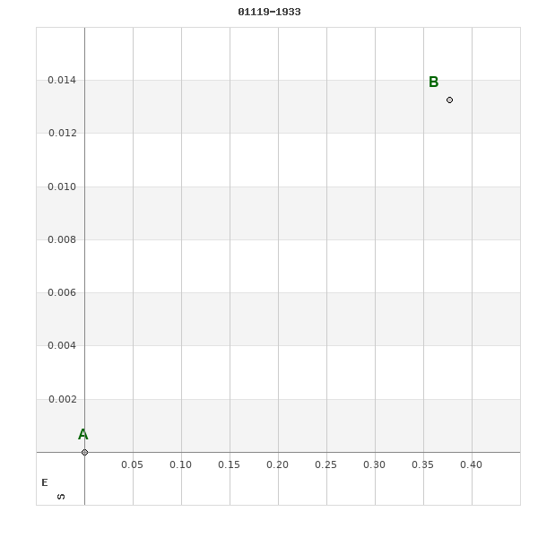
01119-1933 RST 2256
01h 11m 52.41s -19° 33' 05.7" P.A. 272.00 sep 0.4 mag 10.90,12.10
| Coord 2000 |
01119-1933 |
|
Discov num |
RST2256 |
|
Comp |
|
|
Coord arcsec 2000 |
01 11 52.41 -19 33 05.7 |
|
| Date first |
1934 |
|
Date last |
1950 |
|
Obs |
4 |
|
| Pa first |
271 |
|
Pa last |
271.9 |
|
P.A. Now (θ) |
271.9° |
|
| Sep first |
0.4 |
|
Sep last |
0.4 |
|
Sep. Now (ρ) |
0.4" |
|
| Mag pri |
10.90 |
|
Mag sec |
12.10 |
|
delta mag (ΔM) |
1.2 |
|
Spectral class |
|
|
| Pri motion ra |
+042 |
|
Sec motion ra |
|
|
| Pri motion dec |
-016 |
|
Sec motion dec |
|
|
| Notes |
|
|
Nature of this double is uncertain.
OTHER CATALOGS AND DESIGNATIONS
| Constellation |
Cetus |
|
Tycho2 |
5853-01943-1 |
|
Gaia DR2 |
2354580824915856000 |
|
WDS 01119-1933 RST 2256 : NOTES
No records found.
REFERENCES
| refcode |
metd |
author |
reference |
| Rst1933 |
T - |
Rossiter, R.A. |
1933MmRAS..65...27R |
| Rst1933 |
|
MemRAS 65, 27, 1933 |
|
| Rst1937 |
Ma - |
Rossiter, R.A. |
1937MmRAS..65...51R |
| Rst1937 |
|
MemRAS 65, 51, 1937 |
|
| Rst1943 |
Ma - |
Rossiter, R.A. |
1943POMic...8..133R |
| Rst1943 |
|
Pub. Univ. Michigan Obs. 8, 133, 1943 |
|
| Rst1944 |
- |
Rossiter, R.A. |
1944POMic...9....1R |
| Rst1944 |
|
Pub. Univ. Michigan Obs. 9, 1, 1944 |
|
| Rst1947 |
Ma - |
Rossiter, R.A. |
1947POMic...9....7R |
| Rst1947 |
|
Pub. Univ. Michigan Obs. 9, 7, 1947 |
|
| Rst1955 |
Ma j |
Rossiter, R.A. |
1955POMic..11....1R |
| Rst1955 |
+P+ |
Pub. Univ. Michigan Obs. 11, 1, 1955 |
|
| Rst1964 |
Ma - |
Rossiter, R.A. |
1964POMic...9...73R |
| Rst1964 |
|
Pub. Univ. Michigan Obs. 9, 73, 1964 |
|
WDS HISTORIC DATA
| coord_2000 |
discov_num |
comp |
epoch |
obs |
pa |
sep |
mag_pri |
mag_sec |
spectr |
notes |
coord_arcsec_2000 |
| 01119-1933 |
RST2256 |
|
1950 |
4 |
272 |
0.4 |
10.90 |
12.10 |
|
|
011152.41-193305.7 |
If you need more information about this double, apply for a
data request form to the WDS.
WDS 01119-1933 RST 2256 : VISUAL OBSERVATIONS REPORTS
No records found.
WDS 01119-1933 RST 2256 : MEASURES
No records found.
WDS 01119-1933 : VIRTUAL EYEPIECE
Click on the map to see the double of your interest.
Pass over with the mouse cursor to display the catalog designation.
|
|
WDS 01119-1933 : ALADIN DSS IMAGE @ 01h 11m 52.41s -19° 33' 05.7"
WDS 01119-1933 RST 2256 : NEIGHBORHOODS
|
|
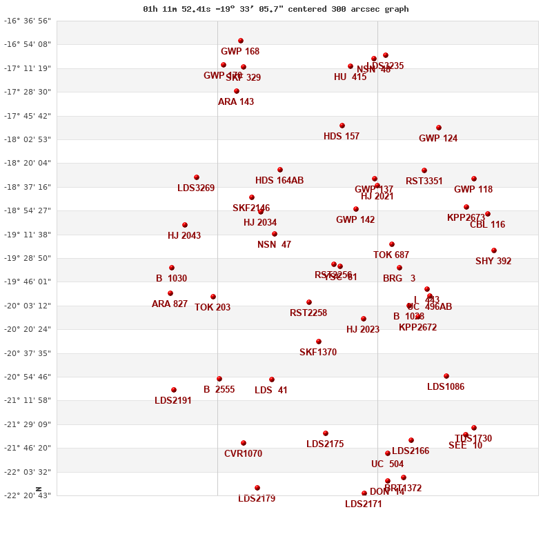
Click on the map to see the double of your interest.
Pass over with the mouse cursor to display the catalog designation.
|
| Show |
name |
coord_2000 |
discov# |
comp |
pa |
sep |
dist(') |
| Show |
|
01119-1933 |
RST2256 |
|
272 |
0.4 |
|
| Show |
|
01114-1935 |
YSC 81 |
|
37 |
0.1 |
7 |
| Show |
|
01137-2001 |
RST2258 |
|
233 |
1.4 |
38 |
| Show |
|
01103-1853 |
GWP 142 |
|
102 |
22.5 |
46 |
| Show |
|
01098-2013 |
HJ 2023 |
|
29 |
3.4 |
50 |
| Show |
|
01130-2029 |
SKF1370 |
|
219 |
1.9 |
59 |
| Show |
|
01077-1919 |
TOK 687 |
|
44 |
0.7 |
61 |
| Show |
|
01161-1911 |
NSN 47 |
|
84 |
4.5 |
64 |
| Show |
|
01072-1936 |
BRG 3 |
|
161 |
0.5 |
67 |
| Show |
|
01088-1837 |
HJ 2021 |
|
120 |
2.3 |
72 |
| Show |
|
01090-1831 |
GWP 137 |
|
166 |
10.4 |
75 |
| Show |
|
01065-2003 |
B 1028 |
|
15 |
0.1 |
82 |
| Show |
|
01171-1855 |
HJ 2034 |
|
153 |
9.2 |
84 |
| Show |
|
01157-1825 |
HDS 164 |
AB |
142 |
0.8 |
88 |
| Show |
|
01059-2011 |
KPP2672 |
|
7 |
4.4 |
94 |
| Show |
|
01052-1951 |
I 443 |
|
310 |
2.4 |
96 |
| Show |
|
01177-1845 |
SKF2146 |
|
228 |
34.7 |
96 |
| Show |
|
01050-1956 |
UC 496 |
AB |
176 |
33.8 |
100 |
| Show |
|
01113-1753 |
HDS 157 |
|
289 |
0.3 |
101 |
| Show |
|
01163-2056 |
LDS 41 |
|
172 |
17.2 |
105 |
| Show |
|
01054-1825 |
RST3351 |
|
71 |
1.1 |
114 |
| Show |
|
01125-2136 |
LDS2175 |
|
328 |
124.8 |
124 |
| Show |
|
01205-1957 |
TOK 203 |
|
128 |
0.3 |
125 |
| Show |
|
01039-2055 |
LDS1086 |
|
301 |
3.3 |
140 |
| Show |
|
01024-1852 |
KPP2673 |
|
80 |
2.5 |
141 |
| Show |
|
01199-2056 |
B 2555 |
|
170 |
2.8 |
143 |
| Show |
|
01107-1710 |
HU 415 |
|
|
1.9 |
145 |
| Show |
|
01044-1754 |
GWP 124 |
|
323 |
7.9 |
146 |
| Show |
|
01080-2150 |
UC 504 |
|
122 |
45.7 |
148 |
| Show |
|
01064-2141 |
LDS2166 |
|
69 |
96.7 |
150 |
| Show |
|
01217-1831 |
LDS3269 |
|
106 |
196.1 |
153 |
| Show |
|
01225-1905 |
HJ 2043 |
|
72 |
5.1 |
154 |
| Show |
|
01090-1704 |
NSN 48 |
|
12 |
8.7 |
155 |
| Show |
|
01019-1831 |
GWP 118 |
|
146 |
13.3 |
155 |
| Show |
|
01183-2143 |
CVR1070 |
|
321 |
3.6 |
158 |
| Show |
|
01188-1728 |
ARA 143 |
|
222 |
7.0 |
160 |
| Show |
|
01081-1702 |
LDS3235 |
|
168 |
10.2 |
160 |
| Show |
|
01009-1857 |
CBL 116 |
|
220 |
25.5 |
160 |
| Show |
|
01005-1923 |
SHY 392 |
|
126 |
999.9 |
162 |
| Show |
|
01235-1936 |
B 1030 |
|
270 |
3.5 |
164 |
| Show |
|
01235-1955 |
ARA 827 |
|
244 |
7.8 |
167 |
| Show |
|
01080-2210 |
DON 14 |
|
77 |
2.8 |
167 |
| Show |
|
01097-2219 |
LDS2171 |
|
209 |
8.7 |
169 |
| Show |
|
01183-1711 |
SKF 329 |
|
135 |
2.5 |
170 |
| Show |
|
01069-2208 |
BRT1372 |
|
188 |
2.4 |
170 |
| Show |
|
01173-2215 |
LDS2179 |
|
186 |
75.6 |
180 |
| Show |
|
01025-2137 |
SEE 10 |
|
312 |
5.8 |
181 |
| Show |
|
01197-1709 |
GWP 170 |
|
66 |
43.8 |
183 |
| Show |
|
01019-2132 |
TDS1730 |
|
29 |
1.6 |
184 |
| Show |
|
01233-2105 |
LDS2191 |
|
311 |
4.4 |
185 |
| Show |
|
01185-1652 |
GWP 168 |
|
174 |
13.2 |
188 |
|
|
WDS 01119-1933 : COMPONENTS
01119-1933 A
| Componente originario normalizzato |
AB |
|
Coord arcsec 2000 |
011152.41-193305.7 |
|
Mag |
10.9 |
|
PmRA |
42.00 |
|
| PmDE |
-16.0 |
|
Tycho2 |
5853-01943-1 |
|
| Tycho2 |
5853-01943-1 |
|
Pflag |
|
|
RAmdeg |
17.96840325 |
|
DEmdeg |
-19.55159744 |
|
| PmRA |
49.3 |
|
PmDE |
-14.9 |
|
E RAmdeg |
43 |
|
E DEmdeg |
41 |
|
| E pmRA |
2.2 |
|
E pmDE |
2.3 |
|
EpRAm |
1985.05 |
|
EpDEm |
1986.30 |
|
| Num |
5 |
|
Q RAmdeg |
1.5 |
|
Q DEmdeg |
0.7 |
|
Q pmRA |
1.5 |
|
| Q pmDE |
0.7 |
|
BTmag |
11.200 |
|
E BTmag |
0.078 |
|
VTmag |
10.597 |
|
| E VTmag |
0.070 |
|
Prox |
999 |
|
TYC |
T |
|
HIP |
|
|
| CCDM |
|
|
RAdeg |
17.96829361 |
|
DEdeg |
-19.55156000 |
|
EpRA 1990 |
1.65 |
|
| EpDE 1990 |
1.72 |
|
E RAdeg |
49.2 |
|
E DEdeg |
45.1 |
|
Posflg |
|
|
| Corr |
-0.2 |
|
| Ccdm |
01119-1933 |
|
RComp |
|
|
Comp |
A |
|
Note1 |
|
|
| Note2 |
|
|
Discov num |
|
|
DRAs |
-1.69 |
|
DDEs |
-5.7 |
|
| R dRAs |
66 |
|
Year |
|
|
Theta |
|
|
Rho |
|
|
| Obs |
2 |
|
Vmag |
10.3 |
|
Sp |
|
|
PmNote |
|
|
| PmRA |
|
|
PmDE |
|
|
Dm number |
-20 216 |
|
Cat1 |
BD |
|
| Name2 |
|
|
Cat2 |
|
|
HD |
|
|
M HD |
|
|
| ADS BDS |
|
|
M ADS BDS |
|
|
N IDS |
|
|
IDS |
01070S2005A |
|
| HIC |
|
|
01119-1933 B
| Componente originario normalizzato |
AB |
|
Coord arcsec 2000 |
011152.38-193305.7 |
|
Mag |
12.1 |
|
Calc delta mag |
1.2 |
|
| Calc coord |
yes |
|
| Ccdm |
01119-1933 |
|
RComp |
|
|
Comp |
B |
|
Note1 |
|
|
| Note2 |
|
|
Discov num |
RST2256 |
|
DRAs |
|
|
DDEs |
|
|
| R dRAs |
|
|
Year |
1935 |
|
Theta |
272 |
|
Rho |
0.4 |
|
| Obs |
3 |
|
Vmag |
11.5 |
|
Sp |
|
|
PmNote |
|
|
| PmRA |
|
|
PmDE |
|
|
Dm number |
|
|
Cat1 |
|
|
| Name2 |
|
|
Cat2 |
|
|
HD |
|
|
M HD |
|
|
| ADS BDS |
|
|
M ADS BDS |
|
|
N IDS |
|
|
IDS |
01070S2005B |
|
| HIC |
|
|