01032+2716 HO 494
01h 03m 11.88s +27° 16' 11.8" P.A. 86.00 sep 14.5 mag 9.09,13.91 Sp K0
| Coord 2000 |
01032+2716 |
|
Discov num |
HO 494 |
|
Comp |
|
|
Coord arcsec 2000 |
01 03 11.88 +27 16 11.8 |
|
| Date first |
1893 |
|
Date last |
2014 |
|
Obs |
9 |
|
| Pa first |
95 |
|
Pa last |
86.3 |
|
P.A. Now (θ) |
86.3° |
|
| Sep first |
11.7 |
|
Sep last |
14.519 |
|
Sep. Now (ρ) |
14.519" |
|
| Mag pri |
9.09 |
|
Mag sec |
13.91 |
|
delta mag (ΔM) |
4.82 |
|
Spectral class |
K0 (yellow-orange) |
|
| Pri motion ra |
-017 |
|
Sec motion ra |
|
|
| Pri motion dec |
-020 |
|
Sec motion dec |
|
|
| Notes |
|
|
Nature of this double is uncertain.
OTHER CATALOGS AND DESIGNATIONS
| Constellation |
Pisces |
|
SAO |
74449 |
|
Tycho2 |
1743-00357-1 |
|
Gaia DR2 |
307602263500190336 |
|
| HD |
6175 |
|
ADS |
867 |
|
WDS 01032+2716 HO 494 : NOTES
No records found.
REFERENCES
| refcode |
metd |
author |
reference |
| Ho_1883 |
Ma j |
Hough, G.W. |
1883MNRAS..43..371H |
| Ho_1883 |
|
MNRAS 43, 371, 1883 (data also in Ho_1890) |
1890AN....125....1H |
| Ho_1884 |
Ma j |
Hough, G.W. |
1884MNRAS..44..365H |
| Ho_1884 |
|
MNRAS 44, 365, 1884 (data also in Ho_1890) |
1890AN....125....1H |
| Ho_1885 |
Ma j |
Hough, G.W. |
1885MNRAS..45..417H |
| Ho_1885 |
|
MNRAS 45, 417, 1885 (data also in Ho_1890) |
1890AN....125....1H |
| Ho_1886 |
Ma j |
Hough, G.W. |
1886MNRAS..46..393H |
| Ho_1886 |
|
MNRAS 46, 393, 1886 (data also in Ho_1890) |
1890AN....125....1H |
| Ho_1887 |
Ma j |
Hough, G.W. |
1887AN....116..273H |
| Ho_1887 |
|
AN 116, 273, 1887 |
|
| Ho_1890 |
Ma j |
Hough, G.W. |
1890AN....125....1H |
| Ho_1890 |
|
AN 125, 1, 1890 |
|
| Ho_1890b |
Ma j |
Hough, G.W. |
1890AJ......9..177H |
| Ho_1890b |
|
AJ 9, 177, 1890 (some data also in Ho_1890 or Ho_1894b) |
1890AN....125....1H |
| Ho_1894a |
Ma - |
Hough, G.W. |
1894MNRAS..54..251H |
| Ho_1894a |
|
MNRAS 54, 251, 1894 |
|
| Ho_1894b |
Ma j |
Hough, G.W. (HO 304 - 490) |
1894AN....135..281H |
| Ho_1894b |
|
AN 135, 281, 1894 |
|
| Ho_1894c |
Ma - |
Hough, G.W. (measure by Dembowski, H.) |
1894AN....135..281H |
| Ho_1894c |
|
AN 135, 281, 1894 |
|
| Ho_1899a |
Ma j |
Hough, G.W. |
1899AN....149..65H |
| Ho_1899a |
|
AN 149, 65, 1899 |
|
| Ho_1899b |
Ma - |
Hough, G.W. (measure by Burnham, S.W.) |
1899AN....149..65H |
| Ho_1899b |
|
AN 149, 65, 1899 |
|
| Ho_1907 |
Ma - |
Hough, G.W. |
1907PFAO....3c...1D |
| Ho_1907 |
|
Pub. Univ. Penn. 3, Pt. 3, 1907 (measures sent to Doolittle) |
|
| Ho_1932A |
Ma - |
Hough, G.W. |
1932QB821.A43...... |
| Ho_1932A |
|
cited in ADS, 1932 (unpublished measures sent to Aitken in manuscript by Fox) |
|
WDS HISTORIC DATA
| coord_2000 |
discov_num |
comp |
epoch |
obs |
pa |
sep |
mag_pri |
mag_sec |
spectr |
notes |
coord_arcsec_2000 |
| 01032+2716 |
HO 494 |
|
1907 |
3 |
95 |
13.1 |
9.09 |
14.10 |
K0 |
|
010311.88+271611.8 |
| 01032+2716 |
HO 494 |
|
2001 |
4 |
88 |
14.3 |
9.09 |
14.10 |
K0 |
|
010311.88+271611.8 |
| 01032+2716 |
HO 494 |
|
2013 |
7 |
85 |
14.2 |
9.09 |
13.91 |
K0 |
|
010311.88+271611.8 |
| 01032+2716 |
HO 494 |
|
2014 |
9 |
86 |
14.5 |
9.09 |
13.91 |
K0 |
|
010311.88+271611.8 |
If you need more information about this double, apply for a
data request form to the WDS.
WDS 01032+2716 HO 494 : VISUAL OBSERVATIONS REPORTS
No records found.
WDS 01032+2716 HO 494 : MEASURES
No records found.
WDS 01032+2716 : VIRTUAL EYEPIECE
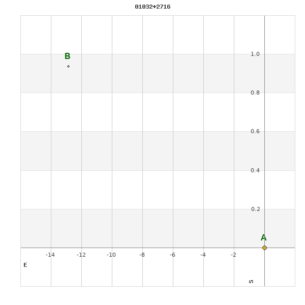
Click on the map to see the double of your interest.
Pass over with the mouse cursor to display the catalog designation.
|
|
WDS 01032+2716 : ALADIN DSS IMAGE @ 01h 03m 11.88s +27° 16' 11.8"
WDS 01032+2716 HO 494 : NEIGHBORHOODS
|
|
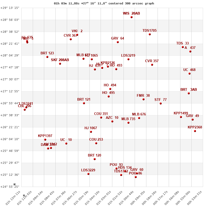
Click on the map to see the double of your interest.
Pass over with the mouse cursor to display the catalog designation.
|
| Show |
name |
coord_2000 |
discov# |
comp |
pa |
sep |
dist(') |
| Show |
|
01032+2716 |
HO 494 |
|
86 |
14.5 |
1 |
| Show |
|
01034+2705 |
HO 495 |
|
242 |
9.7 |
11 |
| Show |
|
01026+2745 |
HO 493 |
|
4 |
30.3 |
30 |
| Show |
|
01040+2747 |
HLD 5 |
|
179 |
3.4 |
33 |
| Show |
|
01034+2748 |
KPP2126 |
|
211 |
17.3 |
33 |
| Show |
|
01048+2744 |
HJ 631 |
|
162 |
17.3 |
36 |
| Show |
|
01058+2655 |
BRT 121 |
|
193 |
2.7 |
41 |
| Show |
|
01041+2635 |
COU 351 |
|
244 |
0.8 |
43 |
| Show |
|
01030+2629 |
AZC 10 |
|
185 |
16.3 |
47 |
| Show |
|
00599+2701 |
FMR 38 |
|
261 |
73.0 |
47 |
| Show |
|
01014+2759 |
LDS3219 |
|
17 |
27.2 |
50 |
| Show |
|
01051+2759 |
HJ 1065 |
|
158 |
23.7 |
50 |
| Show |
|
01014+2627 |
MLB 735 |
|
263 |
3.7 |
55 |
| Show |
|
01049+2800 |
MLB 677 |
|
214 |
8.8 |
57 |
| Show |
|
01003+2636 |
MLB 676 |
|
84 |
5.2 |
57 |
| Show |
|
00590+2751 |
CVR 357 |
|
287 |
23.1 |
67 |
| Show |
|
01052+2614 |
HJ 1067 |
|
239 |
16.0 |
68 |
| Show |
|
01024+2823 |
GRV 64 |
|
359 |
48.2 |
69 |
| Show |
|
00581+2655 |
STF 77 |
|
119 |
10.4 |
72 |
| Show |
|
01083+2753 |
SKF 208 |
AB |
140 |
3.3 |
77 |
| Show |
|
01083+2753 |
HEB 1 |
AC |
128 |
4.6 |
77 |
| Show |
|
01046+2558 |
COU 253 |
|
96 |
1.0 |
81 |
| Show |
|
01072+2828 |
CVR 367 |
|
89 |
17.7 |
90 |
| Show |
|
01065+2834 |
VKI 2 |
|
187 |
2.1 |
90 |
| Show |
|
00592+2835 |
TDS1705 |
|
248 |
0.9 |
95 |
| Show |
|
01096+2802 |
BRT 123 |
|
160 |
4.3 |
97 |
| Show |
|
01076+2557 |
UC 10 |
|
25 |
62.6 |
99 |
| Show |
|
01048+2535 |
BRT 120 |
|
321 |
3.9 |
104 |
| Show |
|
00561+2636 |
KPP1499 |
|
15 |
11.3 |
104 |
| Show |
|
00554+2711 |
BRT 3 |
AB |
337 |
3.4 |
107 |
| Show |
|
00554+2711 |
GRV 50 |
AC |
192 |
60.8 |
107 |
| Show |
|
01010+2900 |
WIS 20 |
AB |
286 |
349.7 |
108 |
| Show |
|
01010+2900 |
WIS 20 |
AC |
3 |
944.9 |
108 |
| Show |
|
00552+2739 |
UC 468 |
|
239 |
37.2 |
109 |
| Show |
|
00559+2817 |
TDS 33 |
|
236 |
1.8 |
115 |
| Show |
|
01098+2603 |
KPP1397 |
|
244 |
10.4 |
115 |
| Show |
|
01026+2521 |
POU 93 |
|
315 |
16.7 |
115 |
| Show |
|
01118+2650 |
LDS3241 |
|
75 |
3.6 |
117 |
| Show |
|
01092+2551 |
HJ 3242 |
|
333 |
8.2 |
118 |
| Show |
|
01118+2646 |
CBL 206 |
|
235 |
20.8 |
120 |
| Show |
|
00548+2631 |
GRV 49 |
|
209 |
26.8 |
120 |
| Show |
|
00551+2811 |
A 437 |
|
29 |
3.1 |
121 |
| Show |
|
01095+2550 |
DAM 376 |
|
91 |
5.2 |
121 |
| Show |
|
01017+2518 |
HDS 134 |
|
215 |
0.1 |
121 |
| Show |
|
01021+2512 |
TDS1732 |
|
283 |
0.5 |
125 |
| Show |
|
01054+2514 |
LDS3229 |
|
160 |
2.4 |
126 |
| Show |
|
01004+2514 |
GRV 60 |
|
4 |
63.1 |
127 |
| Show |
|
00547+2616 |
KPP2368 |
|
146 |
20.3 |
130 |
| Show |
|
01116+2823 |
FMR 5 |
|
294 |
4.7 |
130 |
| Show |
|
01136+2825 |
HJ 635 |
|
127 |
15.0 |
132 |
| Show |
|
01006+2509 |
POU 86 |
|
123 |
15.7 |
132 |
|
|
WDS 01032+2716 : COMPONENTS
01032+2716 A
| Componente originario normalizzato |
AB |
|
Coord arcsec 2000 |
010311.88+271611.8 |
|
Mag |
9.09 |
|
Spectral class |
K0 (yellow-orange) |
|
| PmRA |
-17.00 |
|
PmDE |
-20.0 |
|
SAO |
74449 |
|
Tycho2 |
1743-00357-1 |
|
| HD |
6175 |
|
ADS |
867 |
|
DM |
BD+26 170 |
|
| Tycho2 |
1743-00357-1 |
|
Pflag |
|
|
RAmdeg |
15.79951070 |
|
DEmdeg |
27.26994955 |
|
| PmRA |
-18.1 |
|
PmDE |
-20.0 |
|
E RAmdeg |
12 |
|
E DEmdeg |
15 |
|
| E pmRA |
1.3 |
|
E pmDE |
1.3 |
|
EpRAm |
1989.83 |
|
EpDEm |
1988.55 |
|
| Num |
9 |
|
Q RAmdeg |
0.8 |
|
Q DEmdeg |
0.8 |
|
Q pmRA |
0.8 |
|
| Q pmDE |
0.8 |
|
BTmag |
10.608 |
|
E BTmag |
0.044 |
|
VTmag |
9.094 |
|
| E VTmag |
0.019 |
|
Prox |
999 |
|
TYC |
T |
|
HIP |
|
|
| CCDM |
|
|
RAdeg |
15.79955861 |
|
DEdeg |
27.26999611 |
|
EpRA 1990 |
1.77 |
|
| EpDE 1990 |
1.66 |
|
E RAdeg |
12.8 |
|
E DEdeg |
16.4 |
|
Posflg |
|
|
| Corr |
-0.2 |
|
| SAO |
74449 |
|
DelFlag |
|
|
RA1950 |
|
|
PmRA1950 |
-0.0015 |
|
| DE1950 |
|
|
PmDE1950 |
-0.023 |
|
Vmag |
8.6 |
|
SpType |
K0 |
|
| Double code |
|
|
Source |
34 |
|
CatNum |
617 |
|
DM |
BD+26 170 |
|
| DMcomp |
|
|
BDsup |
|
|
HD |
6175 |
|
M HD |
0 |
|
| GC |
|
|
RA1950rad |
0.26391226 |
|
DE1950rad |
0.47127134 |
|
PmRA2000 |
-0.0015 |
|
| PmDE2000 |
-0.028 |
|
| Ccdm |
01032+2716 |
|
RComp |
|
|
Comp |
A |
|
Note1 |
|
|
| Note2 |
|
|
Discov num |
|
|
DRAs |
-0.12 |
|
DDEs |
13.3 |
|
| R dRAs |
10 |
|
Year |
|
|
Theta |
|
|
Rho |
|
|
| Obs |
2 |
|
Vmag |
8.9 |
|
Sp |
K0 |
|
PmNote |
* |
|
| PmRA |
-11 |
|
PmDE |
3 |
|
Dm number |
+26 170 |
|
Cat1 |
BD |
|
| Name2 |
+27 117 |
|
Cat2 |
AGK2/3 |
|
HD |
6175 |
|
M HD |
|
|
| ADS BDS |
A 867 |
|
M ADS BDS |
|
|
N IDS |
|
|
IDS |
00578N2644A |
|
| HIC |
|
|
01032+2716 B
| Componente originario normalizzato |
AB |
|
Coord arcsec 2000 |
010312.85+271612.7 |
|
Mag |
13.91 |
|
Calc delta mag |
4.82 |
|
| Calc coord |
yes |
|
| Ccdm |
01032+2716 |
|
RComp |
|
|
Comp |
B |
|
Note1 |
|
|
| Note2 |
|
|
Discov num |
HO 494 |
|
DRAs |
|
|
DDEs |
|
|
| R dRAs |
|
|
Year |
1893 |
|
Theta |
095 |
|
Rho |
12.4 |
|
| Obs |
2 |
|
Vmag |
13.9 |
|
Sp |
|
|
PmNote |
|
|
| PmRA |
|
|
PmDE |
|
|
Dm number |
|
|
Cat1 |
|
|
| Name2 |
|
|
Cat2 |
|
|
HD |
|
|
M HD |
|
|
| ADS BDS |
A 867 |
|
M ADS BDS |
|
|
N IDS |
|
|
IDS |
00578N2644B |
|
| HIC |
|
|