01023+1131 PLQ 11
01h 02m 19.39s +11° 31' 18.7" P.A. 3.00 sep 9.9 mag 9.77,12.90 Sp F5
| Coord 2000 |
01023+1131 |
|
Discov num |
PLQ 11 |
|
Comp |
|
|
Coord arcsec 2000 |
01 02 19.39 +11 31 18.7 |
|
| Date first |
1917 |
|
Date last |
2016 |
|
Obs |
15 |
|
| Pa first |
3 |
|
Pa last |
3.2 |
|
P.A. Now (θ) |
3.2° |
|
| Sep first |
9.6 |
|
Sep last |
9.939 |
|
Sep. Now (ρ) |
9.939" |
|
| Mag pri |
9.77 |
|
Mag sec |
12.90 |
|
delta mag (ΔM) |
3.13 |
|
Spectral class |
F5 (yellow-white) |
|
| Pri motion ra |
+127 |
|
Sec motion ra |
+135 |
|
| Pri motion dec |
-097 |
|
Sec motion dec |
+048 |
|
| Notes |
N
V
(See Notes, Proper motion indicates physical) |
|
rPM=0.909
This double is physical.
OTHER CATALOGS AND DESIGNATIONS
| Constellation |
Pisces |
|
Tycho2 |
0615-00136-1 |
|
Gaia DR2 |
2584048180077864960 |
|
WDS 01023+1131 PLQ 11 : NOTES
| discov_num |
notes |
refcode |
| PLQ 11 |
LDS1085. |
|
REFERENCES
| refcode |
metd |
author |
reference |
| Plq1923 |
Ma - |
Paloque, E. |
1923JO......6...25P |
| Plq1923 |
|
J. Obs. 6, 25, 1923 |
|
| Plq1926a |
Ma - |
Paloque, E. |
1926JO......9..115P |
| Plq1926a |
|
J. Obs. 9, 115, 1926 |
|
| Plq1926b |
Ma - |
Paloque, E. |
1926JO......9..129P |
| Plq1926b |
|
J. Obs. 9, 129, 1926 |
|
| Plq1926c |
- |
Paloque, E. |
1926JO......9...12P |
| Plq1926c |
|
J. Obs. 9, 12, 1926 (all data apparently also in Plq1926b) |
1926JO......9..129P |
| Plq1927 |
Mb - |
Paloque, E. |
1927JO.....10..142P |
| Plq1927 |
|
J. Obs. 10, 142, 1927 |
|
| Plq1932A |
Ma - |
Paloque, E. |
1932QB821.A43...... |
| Plq1932A |
|
cited in ADS (Aitken Double Star Cat., 1932) |
|
| Plq1939a |
Pa - |
Paloque, E. |
1939AnTou..15...87P |
| Plq1939a |
|
Ann. Toulouse Obs. 15, 87, 1939 |
|
| Plq1939b |
Pa - |
Paloque, E. |
1939AnTou..15...99P |
| Plq1939b |
+Po |
Ann. Toulouse Obs. 15, 99, 1939 |
|
WDS HISTORIC DATA
| coord_2000 |
discov_num |
comp |
epoch |
obs |
pa |
sep |
mag_pri |
mag_sec |
spectr |
notes |
coord_arcsec_2000 |
| 01023+1131 |
PLQ 11 |
|
2000 |
5 |
3 |
9.9 |
9.77 |
12.90 |
F5 |
N D |
010219.39+113118.7 |
| 01023+1131 |
PLQ 11 |
|
2010 |
8 |
3 |
10.0 |
9.77 |
12.90 |
F5 |
N |
010219.39+113118.7 |
| 01023+1131 |
PLQ 11 |
|
2015 |
9 |
3 |
9.9 |
9.77 |
12.90 |
F5 |
NV |
010219.39+113118.7 |
| 01023+1131 |
PLQ 11 |
|
2016 |
15 |
3 |
9.9 |
9.77 |
12.90 |
F5 |
NV |
010219.39+113118.7 |
If you need more information about this double, apply for a
data request form to the WDS.
WDS 01023+1131 PLQ 11 : VISUAL OBSERVATIONS REPORTS
No records found.
WDS 01023+1131 PLQ 11 : MEASURES
No records found.
WDS 01023+1131 : VIRTUAL EYEPIECE
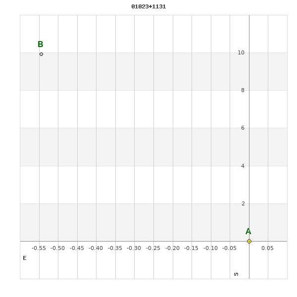
Click on the map to see the double of your interest.
Pass over with the mouse cursor to display the catalog designation.
|
|
WDS 01023+1131 : ALADIN DSS IMAGE @ 01h 02m 19.39s +11° 31' 18.7"
WDS 01023+1131 PLQ 11 : NEIGHBORHOODS
|
|
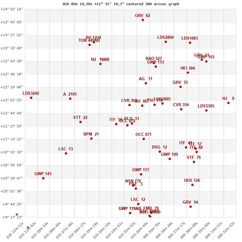
Click on the map to see the double of your interest.
Pass over with the mouse cursor to display the catalog designation.
|
| Show |
name |
coord_2000 |
discov# |
comp |
pa |
sep |
dist(') |
| Show |
|
01023+1131 |
PLQ 11 |
|
3 |
9.9 |
|
| Show |
|
01027+1129 |
OCC 872 |
|
-1 |
0.1 |
7 |
| Show |
|
01038+1130 |
ITF 50 |
|
353 |
11.1 |
22 |
| Show |
|
01025+1156 |
CVR 363 |
|
316 |
10.2 |
25 |
| Show |
|
01012+1111 |
OCC 871 |
|
-1 |
0.1 |
27 |
| Show |
|
01014+1155 |
BU 867 |
|
352 |
0.7 |
28 |
| Show |
|
01002+1156 |
YSC 172 |
|
131 |
0.0 |
40 |
| Show |
|
00595+1158 |
LDS2805 |
|
51 |
50.2 |
50 |
| Show |
|
00598+1054 |
DVG 12 |
|
56 |
54.6 |
54 |
| Show |
|
01010+1224 |
AG 11 |
|
10 |
55.8 |
57 |
| Show |
|
01060+1111 |
BPM 21 |
|
60 |
117.0 |
59 |
| Show |
|
01015+1024 |
GWP 117 |
|
201 |
21.9 |
69 |
| Show |
|
00578+1150 |
CVR 354 |
|
67 |
14.1 |
70 |
| Show |
|
01071+1133 |
STT 22 |
|
202 |
7.6 |
70 |
| Show |
|
00588+1044 |
GWP 109 |
|
212 |
14.5 |
70 |
| Show |
|
00573+1100 |
ITF 49 |
|
291 |
11.3 |
81 |
| Show |
|
01001+1246 |
GWP 113 |
|
138 |
16.4 |
82 |
| Show |
|
00578+1219 |
GRV 55 |
|
105 |
18.1 |
82 |
| Show |
|
01022+1009 |
NSN 776 |
|
284 |
3.4 |
83 |
| Show |
|
01076+2257 |
LDS6410 |
CD |
222 |
8.9 |
83 |
| Show |
|
01003+1251 |
RAO 527 |
|
|
1.1 |
86 |
| Show |
|
01019+1005 |
PRZ 3 |
|
68 |
2.3 |
87 |
| Show |
|
01052+1250 |
HJ 10 |
AB |
314 |
5.0 |
90 |
| Show |
|
01052+1250 |
HJ 10 |
AC |
58 |
8.8 |
90 |
| Show |
|
01052+1250 |
HJ 10 |
BC |
83 |
11.2 |
90 |
| Show |
|
01080+1204 |
A 2101 |
|
260 |
0.7 |
90 |
| Show |
|
00564+1058 |
ITF 57 |
|
302 |
9.7 |
93 |
| Show |
|
00563+1053 |
ITF 48 |
|
126 |
2.1 |
96 |
| Show |
|
01084+1052 |
LSC 13 |
|
16 |
0.2 |
98 |
| Show |
|
00566+1040 |
STF 76 |
|
199 |
3.0 |
99 |
| Show |
|
00571+1239 |
HEI 304 |
|
87 |
0.8 |
102 |
| Show |
|
00554+1149 |
LDS5305 |
|
274 |
8.4 |
103 |
| Show |
|
01017+0945 |
LSC 12 |
|
228 |
1.1 |
107 |
| Show |
|
00567+1010 |
HDS 126 |
|
65 |
0.8 |
116 |
| Show |
|
00592+1319 |
LDS2804 |
|
354 |
3.2 |
118 |
| Show |
|
01062+1315 |
TOK 449 |
AB |
285 |
999.9 |
119 |
| Show |
|
01025+0933 |
GWP 119 |
AB |
107 |
29.4 |
119 |
| Show |
|
01025+0933 |
GWP 119 |
AC |
247 |
1.4 |
119 |
| Show |
|
01058+1319 |
BU 1228 |
|
258 |
0.5 |
120 |
| Show |
|
01005+0933 |
FMR 39 |
|
251 |
19.4 |
122 |
| Show |
|
01007+0929 |
STF 82 |
AB |
304 |
1.9 |
125 |
| Show |
|
01007+0929 |
DOO 25 |
AC |
214 |
74.5 |
125 |
| Show |
|
01007+0929 |
DOO 25 |
CD |
197 |
10.6 |
126 |
| Show |
|
00558+1255 |
GRV 51 |
|
240 |
60.3 |
127 |
| Show |
|
00554+1253 |
GWP 103 |
|
113 |
25.5 |
130 |
| Show |
|
00569+1318 |
LDS1083 |
|
154 |
3.1 |
133 |
| Show |
|
00534+1159 |
HJ 9 |
|
100 |
12.5 |
134 |
| Show |
|
00568+0941 |
GRV 54 |
|
334 |
17.0 |
136 |
| Show |
|
01013+1348 |
GRV 62 |
|
358 |
67.4 |
138 |
| Show |
|
01117+1205 |
LDS3242 |
|
300 |
260.4 |
141 |
| Show |
|
01105+1019 |
GWP 143 |
|
305 |
3.6 |
141 |
|
|
WDS 01023+1131 : COMPONENTS
01023+1131 A
| Componente originario normalizzato |
AB |
|
Coord arcsec 2000 |
010219.39+113118.7 |
|
Mag |
9.77 |
|
Spectral class |
F5 (yellow-white) |
|
| PmRA |
127.00 |
|
PmDE |
-97.0 |
|
Tycho2 |
0615-00136-1 |
|
DM |
BD+10 116 |
|
| Tycho2 |
0615-00136-1 |
|
Pflag |
|
|
RAmdeg |
15.58079667 |
|
DEmdeg |
11.52188186 |
|
| PmRA |
125.4 |
|
PmDE |
-90.5 |
|
E RAmdeg |
19 |
|
E DEmdeg |
23 |
|
| E pmRA |
1.3 |
|
E pmDE |
1.2 |
|
EpRAm |
1988.59 |
|
EpDEm |
1986.19 |
|
| Num |
8 |
|
Q RAmdeg |
0.4 |
|
Q DEmdeg |
0.4 |
|
Q pmRA |
0.4 |
|
| Q pmDE |
0.4 |
|
BTmag |
10.126 |
|
E BTmag |
0.034 |
|
VTmag |
9.770 |
|
| E VTmag |
0.036 |
|
Prox |
999 |
|
TYC |
T |
|
HIP |
|
|
| CCDM |
|
|
RAdeg |
15.58050389 |
|
DEdeg |
11.52209083 |
|
EpRA 1990 |
1.76 |
|
| EpDE 1990 |
1.71 |
|
E RAdeg |
19.1 |
|
E DEdeg |
24.0 |
|
Posflg |
|
|
| Corr |
0.0 |
|
| Ccdm |
01023+1131 |
|
RComp |
|
|
Comp |
A |
|
Note1 |
|
|
| Note2 |
|
|
Discov num |
|
|
DRAs |
1.36 |
|
DDEs |
18.0 |
|
| R dRAs |
10 |
|
Year |
|
|
Theta |
|
|
Rho |
|
|
| Obs |
2 |
|
Vmag |
10.2 |
|
Sp |
F5 |
|
PmNote |
* |
|
| PmRA |
117 |
|
PmDE |
-102 |
|
Dm number |
+10 116 |
|
Cat1 |
BD |
|
| Name2 |
+11 100 |
|
Cat2 |
AGK2/3 |
|
HD |
|
|
M HD |
|
|
| ADS BDS |
|
|
M ADS BDS |
|
|
N IDS |
|
|
IDS |
00571N1059A |
|
| HIC |
|
|
01023+1131 B
| Componente originario normalizzato |
AB |
|
Coord arcsec 2000 |
010219.43+113128.6 |
|
Mag |
12.9 |
|
PmRA |
135.00 |
|
| PmDE |
48.0 |
|
Calc delta mag |
3.13 |
|
Calc coord |
yes |
|
| Ccdm |
01023+1131 |
|
RComp |
|
|
Comp |
B |
|
Note1 |
|
|
| Note2 |
|
|
Discov num |
PLQ 11 |
|
DRAs |
|
|
DDEs |
|
|
| R dRAs |
|
|
Year |
1917 |
|
Theta |
005 |
|
Rho |
9.6 |
|
| Obs |
5 |
|
Vmag |
13.3 |
|
Sp |
|
|
PmNote |
|
|
| PmRA |
|
|
PmDE |
|
|
Dm number |
|
|
Cat1 |
|
|
| Name2 |
|
|
Cat2 |
|
|
HD |
|
|
M HD |
|
|
| ADS BDS |
|
|
M ADS BDS |
|
|
N IDS |
|
|
IDS |
00571N1059B |
|
| HIC |
|
|