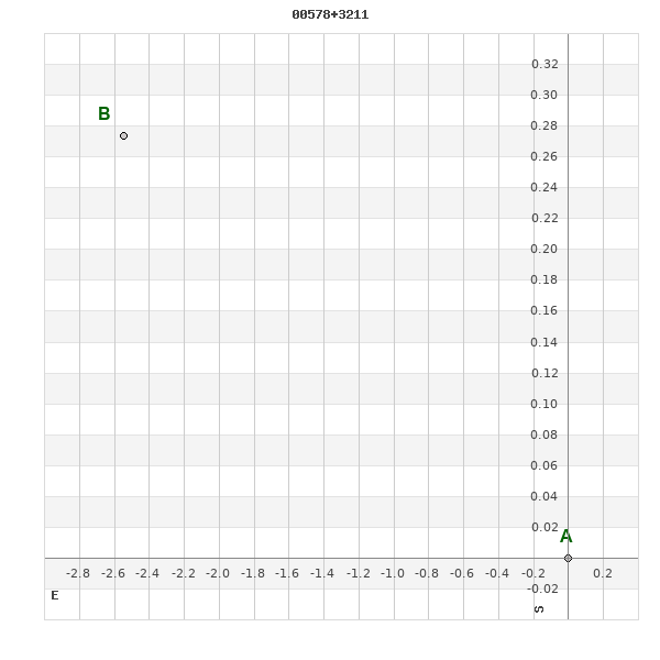
00578+3211 HO 307
00h 57m 39.64s +32° 12' 07.4" P.A. 85.00 sep 3.0 mag 10.10,10.30
| Coord 2000 |
00578+3211 |
|
Discov num |
HO 307 |
|
Comp |
|
|
Coord arcsec 2000 |
00 57 39.64 +32 12 07.4 |
|
| Date first |
1891 |
|
Date last |
2015 |
|
Obs |
20 |
|
| Pa first |
85 |
|
Pa last |
84.8 |
|
P.A. Now (θ) |
84.8° |
|
| Sep first |
1.8 |
|
Sep last |
3.023 |
|
Sep. Now (ρ) |
3.023" |
|
| Mag pri |
10.10 |
|
Mag sec |
10.30 |
|
delta mag (ΔM) |
0.2 |
|
Spectral class |
|
|
| Pri motion ra |
-021 |
|
Sec motion ra |
+017 |
|
| Pri motion dec |
-016 |
|
Sec motion dec |
-008 |
|
| Notes |
|
|
rPM=1.471
This double is not physical.
OTHER CATALOGS AND DESIGNATIONS
| Constellation |
Pisces |
|
Tycho2 |
2281-00180-1 |
|
Gaia DR2 |
312922761611851136 |
|
WDS 00578+3211 HO 307 : NOTES
No records found.
REFERENCES
| refcode |
metd |
author |
reference |
| Ho_1883 |
Ma j |
Hough, G.W. |
1883MNRAS..43..371H |
| Ho_1883 |
|
MNRAS 43, 371, 1883 (data also in Ho_1890) |
1890AN....125....1H |
| Ho_1884 |
Ma j |
Hough, G.W. |
1884MNRAS..44..365H |
| Ho_1884 |
|
MNRAS 44, 365, 1884 (data also in Ho_1890) |
1890AN....125....1H |
| Ho_1885 |
Ma j |
Hough, G.W. |
1885MNRAS..45..417H |
| Ho_1885 |
|
MNRAS 45, 417, 1885 (data also in Ho_1890) |
1890AN....125....1H |
| Ho_1886 |
Ma j |
Hough, G.W. |
1886MNRAS..46..393H |
| Ho_1886 |
|
MNRAS 46, 393, 1886 (data also in Ho_1890) |
1890AN....125....1H |
| Ho_1887 |
Ma j |
Hough, G.W. |
1887AN....116..273H |
| Ho_1887 |
|
AN 116, 273, 1887 |
|
| Ho_1890 |
Ma j |
Hough, G.W. |
1890AN....125....1H |
| Ho_1890 |
|
AN 125, 1, 1890 |
|
| Ho_1890b |
Ma j |
Hough, G.W. |
1890AJ......9..177H |
| Ho_1890b |
|
AJ 9, 177, 1890 (some data also in Ho_1890 or Ho_1894b) |
1890AN....125....1H |
| Ho_1894a |
Ma - |
Hough, G.W. |
1894MNRAS..54..251H |
| Ho_1894a |
|
MNRAS 54, 251, 1894 |
|
| Ho_1894b |
Ma j |
Hough, G.W. (HO 304 - 490) |
1894AN....135..281H |
| Ho_1894b |
|
AN 135, 281, 1894 |
|
| Ho_1894c |
Ma - |
Hough, G.W. (measure by Dembowski, H.) |
1894AN....135..281H |
| Ho_1894c |
|
AN 135, 281, 1894 |
|
| Ho_1899a |
Ma j |
Hough, G.W. |
1899AN....149..65H |
| Ho_1899a |
|
AN 149, 65, 1899 |
|
| Ho_1899b |
Ma - |
Hough, G.W. (measure by Burnham, S.W.) |
1899AN....149..65H |
| Ho_1899b |
|
AN 149, 65, 1899 |
|
| Ho_1907 |
Ma - |
Hough, G.W. |
1907PFAO....3c...1D |
| Ho_1907 |
|
Pub. Univ. Penn. 3, Pt. 3, 1907 (measures sent to Doolittle) |
|
| Ho_1932A |
Ma - |
Hough, G.W. |
1932QB821.A43...... |
| Ho_1932A |
|
cited in ADS, 1932 (unpublished measures sent to Aitken in manuscript by Fox) |
|
WDS HISTORIC DATA
| coord_2000 |
discov_num |
comp |
epoch |
obs |
pa |
sep |
mag_pri |
mag_sec |
spectr |
notes |
coord_arcsec_2000 |
| 00578+3211 |
HO 307 |
|
1999 |
15 |
84 |
3.0 |
10.10 |
10.30 |
|
D |
005739.64+321207.4 |
| 00578+3211 |
HO 307 |
|
2010 |
16 |
85 |
2.9 |
10.10 |
10.30 |
|
D |
005739.64+321207.4 |
| 00578+3211 |
HO 307 |
|
2011 |
17 |
85 |
2.9 |
10.10 |
10.30 |
|
D |
005739.64+321207.4 |
| 00578+3211 |
HO 307 |
|
2012 |
19 |
84 |
3.0 |
10.10 |
10.30 |
|
|
005739.64+321207.4 |
| 00578+3211 |
HO 307 |
|
2015 |
20 |
85 |
3.0 |
10.10 |
10.30 |
|
|
005739.64+321207.4 |
If you need more information about this double, apply for a
data request form to the WDS.
WDS 00578+3211 HO 307 : VISUAL OBSERVATIONS REPORTS
No records found.
WDS 00578+3211 HO 307 : MEASURES
No records found.
WDS 00578+3211 : VIRTUAL EYEPIECE
Click on the map to see the double of your interest.
Pass over with the mouse cursor to display the catalog designation.
|
|
WDS 00578+3211 : ALADIN DSS IMAGE @ 00h 57m 39.64s +32° 12' 07.4"
WDS 00578+3211 HO 307 : NEIGHBORHOODS
|
|
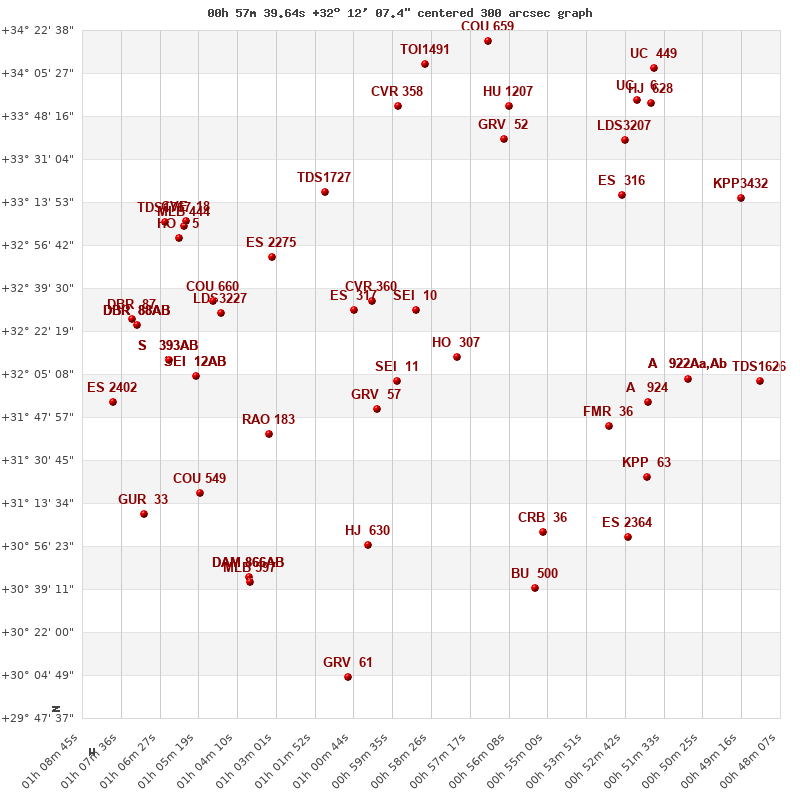
Click on the map to see the double of your interest.
Pass over with the mouse cursor to display the catalog designation.
|
| Show |
name |
coord_2000 |
discov# |
comp |
pa |
sep |
dist(') |
| Show |
|
00578+3211 |
HO 307 |
|
85 |
3.0 |
|
| Show |
|
00589+3230 |
SEI 10 |
|
100 |
12.4 |
25 |
| Show |
|
00595+3202 |
SEI 11 |
|
359 |
8.5 |
25 |
| Show |
|
01000+3151 |
GRV 57 |
|
148 |
77.0 |
37 |
| Show |
|
01002+3234 |
CVR 360 |
|
90 |
28.2 |
40 |
| Show |
|
01004+3228 |
ES 317 |
|
194 |
7.1 |
43 |
| Show |
|
00532+3144 |
FMR 36 |
|
40 |
159.6 |
64 |
| Show |
|
00520+3154 |
A 924 |
|
306 |
0.4 |
75 |
| Show |
|
00551+3102 |
CRB 36 |
|
219 |
12.9 |
78 |
| Show |
|
01032+3141 |
RAO 183 |
|
148 |
0.2 |
78 |
| Show |
|
01031+3252 |
ES 2275 |
|
145 |
3.2 |
80 |
| Show |
|
01016+3318 |
TDS1727 |
|
94 |
0.4 |
83 |
| Show |
|
01003+3057 |
HJ 630 |
|
197 |
6.3 |
83 |
| Show |
|
00521+3124 |
KPP 63 |
|
197 |
3.6 |
87 |
| Show |
|
00508+3203 |
A 922 |
Aa,Ab |
336 |
0.6 |
88 |
| Show |
|
00508+3203 |
UC 447 |
AB |
11 |
63.2 |
88 |
| Show |
|
00562+3339 |
GRV 52 |
|
194 |
19.3 |
89 |
| Show |
|
00527+3316 |
ES 316 |
|
299 |
2.7 |
90 |
| Show |
|
01047+3229 |
LDS3227 |
|
197 |
82.5 |
91 |
| Show |
|
01049+3234 |
COU 660 |
|
191 |
3.3 |
95 |
| Show |
|
00526+3100 |
ES 2364 |
|
135 |
6.2 |
97 |
| Show |
|
00554+3040 |
BU 500 |
|
123 |
0.5 |
97 |
| Show |
|
01054+3204 |
SEI 12 |
AB |
119 |
3.6 |
99 |
| Show |
|
01054+3204 |
ORL 5 |
AC |
185 |
0.5 |
99 |
| Show |
|
00561+3352 |
HU 1207 |
|
187 |
0.4 |
103 |
| Show |
|
00594+3353 |
CVR 358 |
|
10 |
14.4 |
103 |
| Show |
|
00527+3339 |
LDS3207 |
|
299 |
13.1 |
107 |
| Show |
|
01062+3211 |
S 393 |
AB |
295 |
60.0 |
109 |
| Show |
|
01062+3211 |
S 393 |
AC |
234 |
138.9 |
109 |
| Show |
|
01053+3117 |
COU 549 |
|
255 |
1.3 |
112 |
| Show |
|
00487+3202 |
TDS1626 |
|
159 |
1.2 |
115 |
| Show |
|
01059+3300 |
HO 5 |
|
310 |
0.4 |
115 |
| Show |
|
01057+3304 |
MLB 444 |
|
30 |
10.4 |
115 |
| Show |
|
01057+3306 |
CVE 18 |
|
257 |
7.6 |
115 |
| Show |
|
00586+3409 |
TOI1491 |
|
270 |
0.8 |
118 |
| Show |
|
01038+3044 |
DAM 866 |
AB |
217 |
136.2 |
119 |
| Show |
|
01038+3044 |
DAM 866 |
AC |
148 |
169.7 |
119 |
| Show |
|
01038+3042 |
MLB 597 |
|
95 |
3.0 |
120 |
| Show |
|
01071+3225 |
DBR 88 |
AB |
318 |
13.8 |
121 |
| Show |
|
01071+3225 |
DBR 88 |
AC |
75 |
6.2 |
121 |
| Show |
|
01071+3225 |
DBR 88 |
AD |
199 |
2.9 |
121 |
| Show |
|
01063+3306 |
TDS1767 |
|
180 |
0.9 |
122 |
| Show |
|
00524+3355 |
UC 6 |
|
112 |
50.2 |
123 |
| Show |
|
01073+3227 |
DBR 87 |
|
108 |
1.6 |
123 |
| Show |
|
00493+3316 |
KPP3432 |
|
47 |
1.1 |
124 |
| Show |
|
00520+3353 |
HJ 628 |
|
66 |
42.8 |
125 |
| Show |
|
00567+3417 |
COU 659 |
|
214 |
1.1 |
127 |
| Show |
|
01079+3153 |
ES 2402 |
|
242 |
2.8 |
131 |
| Show |
|
01069+3109 |
GUR 33 |
|
147 |
0.2 |
135 |
| Show |
|
01008+3003 |
GRV 61 |
|
191 |
37.4 |
135 |
| Show |
|
00519+3407 |
UC 449 |
|
223 |
8.1 |
137 |
|
|
WDS 00578+3211 : COMPONENTS
00578+3211 A
| Componente originario normalizzato |
AB |
|
Coord arcsec 2000 |
005739.64+321207.4 |
|
Mag |
10.1 |
|
PmRA |
-21.00 |
|
| PmDE |
-16.0 |
|
00578+3211 B
| Componente originario normalizzato |
AB |
|
Coord arcsec 2000 |
005739.84+321207.7 |
|
Mag |
10.3 |
|
PmRA |
17.00 |
|
| PmDE |
-8.0 |
|
Tycho2 |
2281-00180-1 |
|
Calc delta mag |
0.2 |
|
Calc coord |
yes |
|
| Tycho2 |
2281-00180-1 |
|
Pflag |
|
|
RAmdeg |
14.41514998 |
|
DEmdeg |
32.20204710 |
|
| PmRA |
-20.4 |
|
PmDE |
-13.1 |
|
E RAmdeg |
31 |
|
E DEmdeg |
43 |
|
| E pmRA |
1.9 |
|
E pmDE |
1.9 |
|
EpRAm |
1988.57 |
|
EpDEm |
1985.49 |
|
| Num |
4 |
|
Q RAmdeg |
1.5 |
|
Q DEmdeg |
0.3 |
|
Q pmRA |
1.4 |
|
| Q pmDE |
0.4 |
|
BTmag |
11.404 |
|
E BTmag |
0.068 |
|
VTmag |
10.690 |
|
| E VTmag |
0.056 |
|
Prox |
999 |
|
TYC |
T |
|
HIP |
|
|
| CCDM |
|
|
RAdeg |
14.41520389 |
|
DEdeg |
32.20207639 |
|
EpRA 1990 |
1.88 |
|
| EpDE 1990 |
1.87 |
|
E RAdeg |
31.8 |
|
E DEdeg |
44.8 |
|
Posflg |
|
|
| Corr |
0.0 |
|