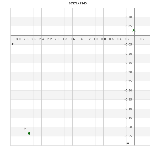
00571+1943 ROE 106
00h 57m 07.72s +19° 42' 57.8" P.A. 100.00 sep 3.0 mag 11.50,11.70
| Coord 2000 |
00571+1943 |
|
Discov num |
ROE 106 |
|
Comp |
|
|
Coord arcsec 2000 |
00 57 07.72 +19 42 57.8 |
|
| Date first |
1916 |
|
Date last |
2016 |
|
Obs |
10 |
|
| Pa first |
98 |
|
Pa last |
99.6 |
|
P.A. Now (θ) |
99.6° |
|
| Sep first |
1.6 |
|
Sep last |
3.045 |
|
Sep. Now (ρ) |
3.045" |
|
| Mag pri |
11.50 |
|
Mag sec |
11.70 |
|
delta mag (ΔM) |
0.2 |
|
Spectral class |
|
|
| Pri motion ra |
-019 |
|
Sec motion ra |
+007 |
|
| Pri motion dec |
-012 |
|
Sec motion dec |
-007 |
|
| Notes |
|
|
rPM=1.178
This double is not physical.
OTHER CATALOGS AND DESIGNATIONS
| Constellation |
Pisces |
|
Tycho2 |
1192-00708-1 |
|
Gaia DR2 |
2789426777368373760 |
|
ADS |
794 |
|
WDS 00571+1943 ROE 106 : NOTES
No records found.
REFERENCES
| refcode |
metd |
author |
reference |
| Roe1908 |
Ma - |
Roe, E.D. |
1908AN....178..169R |
| Roe1908 |
|
AN 178, 169, 1908 |
|
| Roe1909 |
Ma - |
Roe, E.D. |
1909AN....181..285R |
| Roe1909 |
|
AN 181, 285, 1909 |
|
| Roe1910a |
Ma - |
Roe, E.D. |
1910AJ.....26...93R |
| Roe1910a |
|
AJ 26, 93, 1910 |
|
| Roe1910b |
Ma j |
Roe, E.D. |
................... |
| Roe1910b |
|
Journal Astronomique 1, no. 4, 25, 1910 |
|
| Roe1910c |
Ma - |
Roe, E.D. |
1910AN....183..197R |
| Roe1910c |
|
AN 183, 197, 1910 |
|
| Roe1910d |
Ma j |
Roe, E.D. |
1910PA.....18..354R |
| Roe1910d |
|
Popular Astronomy 18, 354, 1910 |
|
| Roe1910e |
Ma j |
Roe, E.D. |
1910PA.....18..554R |
| Roe1910e |
|
Popular Astronomy 18, 554, 1910 |
|
| Roe1911a |
Ma - |
Roe, E.D. |
1911AN....187...39R |
| Roe1911a |
|
AN 187, 39, 1911 |
|
| Roe1911b |
Ma - |
Roe, E.D. |
1911AN....188..373R |
| Roe1911b |
|
AN 188, 373, 1911 |
|
| Roe1911c |
Ma - |
Roe, E.D. |
1911AN....190..137R |
| Roe1911c |
|
AN 190, 137, 1911 |
|
| Roe1911d |
Ma j |
Roe, E.D. |
1911PA.....19..383R |
| Roe1911d |
|
Popular Astronomy 19, 383, 1911 |
|
| Roe1914 |
Ma j |
Roe, E.D. |
1914AN....199..169R |
| Roe1914 |
|
AN 199, 169, 1914 |
|
| Roe1915 |
Ma - |
Roe, E.D. |
1915AN....202..99R |
| Roe1915 |
|
AN 202, 99, 1915 |
|
| Roe1917 |
Ma j |
Roe, E.D. |
1917AN....204...21R |
| Roe1917 |
|
AN 204, 21, 1917 |
|
| Roe1918 |
Ma - |
Roe, E.D. |
1918AJ.....31..149R |
| Roe1918 |
|
AJ 31, 149, 1918 |
|
| Roe1919a |
Ma j |
Roe, E.D. |
1919AJ.....32....6R |
| Roe1919a |
|
AJ 32, 6, 1919 |
|
| Roe1919b |
Ma j |
Roe, E.D. |
1919AJ.....32...25R |
| Roe1919b |
|
AJ 32, 25, 1919 |
|
| Roe1932A |
- |
Roe, E.D. |
1932QB821.A43...... |
| Roe1932A |
|
cited in ADS (Aitken Double Star Cat.), 1932 |
|
WDS HISTORIC DATA
| coord_2000 |
discov_num |
comp |
epoch |
obs |
pa |
sep |
mag_pri |
mag_sec |
spectr |
notes |
coord_arcsec_2000 |
| 00571+1943 |
ROE 106 |
|
2002 |
6 |
99 |
2.9 |
11.50 |
11.70 |
|
|
005707.72+194257.8 |
| 00571+1943 |
ROE 106 |
|
2015 |
8 |
100 |
3.0 |
11.50 |
11.70 |
|
|
005707.72+194257.8 |
| 00571+1943 |
ROE 106 |
|
2016 |
10 |
100 |
3.0 |
11.50 |
11.70 |
|
|
005707.72+194257.8 |
If you need more information about this double, apply for a
data request form to the WDS.
WDS 00571+1943 ROE 106 : VISUAL OBSERVATIONS REPORTS
No records found.
WDS 00571+1943 ROE 106 : MEASURES
No records found.
WDS 00571+1943 : VIRTUAL EYEPIECE
Click on the map to see the double of your interest.
Pass over with the mouse cursor to display the catalog designation.
|
|
WDS 00571+1943 : ALADIN DSS IMAGE @ 00h 57m 07.72s +19° 42' 57.8"
WDS 00571+1943 ROE 106 : NEIGHBORHOODS
|
|
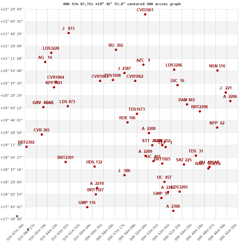
Click on the map to see the double of your interest.
Pass over with the mouse cursor to display the catalog designation.
|
| Show |
name |
coord_2000 |
discov# |
comp |
pa |
sep |
dist(') |
| Show |
|
00571+1943 |
ROE 106 |
|
100 |
3.0 |
|
| Show |
|
00562+1955 |
TDS1673 |
|
248 |
0.9 |
19 |
| Show |
|
00549+1928 |
A 2208 |
|
91 |
1.6 |
35 |
| Show |
|
00546+1911 |
STT 20 |
AB |
176 |
0.6 |
48 |
| Show |
|
00546+1911 |
BU 1352 |
AB,C |
9 |
150.2 |
48 |
| Show |
|
00553+1856 |
A 2209 |
|
154 |
1.8 |
54 |
| Show |
|
00564+2041 |
CVR1062 |
|
212 |
4.8 |
59 |
| Show |
|
00536+1911 |
COU 252 |
|
99 |
0.3 |
60 |
| Show |
|
00586+2042 |
TDS1698 |
|
6 |
1.7 |
64 |
| Show |
|
00532+1909 |
LEP 3 |
|
234 |
81.5 |
65 |
| Show |
|
00545+1849 |
UC 465 |
|
311 |
62.7 |
66 |
| Show |
|
00574+2053 |
J 2587 |
|
113 |
4.0 |
70 |
| Show |
|
00599+2041 |
CVR1063 |
|
108 |
5.0 |
71 |
| Show |
|
00574+1829 |
J 586 |
|
45 |
1.7 |
74 |
| Show |
|
00536+1846 |
BRT1925 |
|
121 |
2.4 |
77 |
| Show |
|
01005+1841 |
HDS 132 |
|
138 |
0.4 |
78 |
| Show |
|
00555+2103 |
AZC 9 |
|
10 |
16.3 |
84 |
| Show |
|
00520+2035 |
GIC 16 |
|
56 |
999.9 |
89 |
| Show |
|
01032+2006 |
LDS 873 |
|
58 |
2.4 |
90 |
| Show |
|
00510+2008 |
DAM 865 |
|
349 |
3.8 |
90 |
| Show |
|
00534+1820 |
UC 457 |
|
262 |
8.9 |
99 |
| Show |
|
00524+2057 |
LDS3206 |
|
241 |
24.8 |
100 |
| Show |
|
00514+1844 |
SKF 225 |
|
142 |
12.7 |
101 |
| Show |
|
01003+1812 |
A 2210 |
|
294 |
5.6 |
102 |
| Show |
|
00583+2124 |
BU 302 |
|
231 |
0.3 |
103 |
| Show |
|
01035+1848 |
BRT2301 |
|
143 |
4.0 |
106 |
| Show |
|
00497+1959 |
BRT2298 |
|
198 |
3.6 |
106 |
| Show |
|
00501+1857 |
TDS 31 |
|
123 |
0.9 |
110 |
| Show |
|
01004+1803 |
BRT1927 |
|
170 |
1.9 |
111 |
| Show |
|
00530+1806 |
A 2207 |
|
168 |
3.7 |
114 |
| Show |
|
00537+1758 |
GWP 97 |
|
345 |
11.1 |
117 |
| Show |
|
01046+2032 |
KPP1481 |
|
304 |
11.1 |
117 |
| Show |
|
01045+2039 |
CVR1064 |
|
330 |
3.4 |
118 |
| Show |
|
00519+1807 |
LDS3205 |
|
263 |
177.6 |
123 |
| Show |
|
01057+2004 |
GRV 68 |
AB |
36 |
44.7 |
124 |
| Show |
|
01057+2004 |
WSI 144 |
AC |
49 |
11.4 |
124 |
| Show |
|
01059+1926 |
CVR 365 |
|
92 |
13.0 |
125 |
| Show |
|
00480+1936 |
KPP 62 |
|
285 |
3.5 |
130 |
| Show |
|
01013+1745 |
GWP 116 |
|
6 |
17.7 |
132 |
| Show |
|
00487+1841 |
RAO 5 |
Ca,Cb |
321 |
0.7 |
134 |
| Show |
|
00487+1841 |
BU 495 |
AB |
238 |
0.4 |
134 |
| Show |
|
00487+1841 |
TOK 224 |
AC |
139 |
152.3 |
134 |
| Show |
|
00525+1740 |
A 2306 |
|
302 |
1.4 |
140 |
| Show |
|
01055+2107 |
AG 14 |
|
309 |
0.8 |
146 |
| Show |
|
01050+2119 |
LDS3228 |
|
48 |
27.8 |
147 |
| Show |
|
00471+2025 |
J 221 |
|
7 |
5.8 |
148 |
| Show |
|
00479+2056 |
NSN 510 |
|
198 |
30.1 |
149 |
| Show |
|
01074+1909 |
BRT2302 |
|
134 |
4.5 |
150 |
| Show |
|
01032+2146 |
J 873 |
|
232 |
2.9 |
151 |
| Show |
|
00466+2013 |
A 2206 |
|
294 |
4.6 |
152 |
| Show |
|
00553+2213 |
CVR1061 |
|
233 |
3.8 |
153 |
|
|
WDS 00571+1943 : COMPONENTS
00571+1943 A
| Componente originario normalizzato |
AB |
|
Coord arcsec 2000 |
005707.72+194257.8 |
|
Mag |
11.5 |
|
PmRA |
-19.00 |
|
| PmDE |
-12.0 |
|
Tycho2 |
1192-00708-1 |
|
ADS |
794 |
|
DM |
BD+18 128 |
|
| Tycho2 |
1192-00708-1 |
|
Pflag |
|
|
RAmdeg |
14.28219484 |
|
DEmdeg |
19.71607769 |
|
| PmRA |
-17.2 |
|
PmDE |
-13.5 |
|
E RAmdeg |
35 |
|
E DEmdeg |
43 |
|
| E pmRA |
1.2 |
|
E pmDE |
1.3 |
|
EpRAm |
1982.35 |
|
EpDEm |
1977.54 |
|
| Num |
4 |
|
Q RAmdeg |
0.4 |
|
Q DEmdeg |
1.3 |
|
Q pmRA |
0.4 |
|
| Q pmDE |
1.2 |
|
BTmag |
11.301 |
|
E BTmag |
0.079 |
|
VTmag |
10.524 |
|
| E VTmag |
0.056 |
|
Prox |
999 |
|
TYC |
T |
|
HIP |
|
|
| CCDM |
|
|
RAdeg |
14.28223694 |
|
DEdeg |
19.71610861 |
|
EpRA 1990 |
1.63 |
|
| EpDE 1990 |
1.69 |
|
E RAdeg |
37.4 |
|
E DEdeg |
46.7 |
|
Posflg |
|
|
| Corr |
0.0 |
|
| Ccdm |
00571+1943 |
|
RComp |
|
|
Comp |
A |
|
Note1 |
|
|
| Note2 |
|
|
Discov num |
|
|
DRAs |
1.83 |
|
DDEs |
-2.4 |
|
| R dRAs |
65 |
|
Year |
|
|
Theta |
|
|
Rho |
|
|
| Obs |
2 |
|
Vmag |
11.5 |
|
Sp |
|
|
PmNote |
|
|
| PmRA |
|
|
PmDE |
|
|
Dm number |
+18 128 |
|
Cat1 |
BD |
|
| Name2 |
|
|
Cat2 |
|
|
HD |
|
|
M HD |
|
|
| ADS BDS |
A 794 |
|
M ADS BDS |
|
|
N IDS |
|
|
IDS |
00518N1911A |
|
| HIC |
|
|
00571+1943 B
| Componente originario normalizzato |
AB |
|
Coord arcsec 2000 |
005707.92+194257.3 |
|
Mag |
11.7 |
|
PmRA |
7.00 |
|
| PmDE |
-7.0 |
|
Calc delta mag |
0.2 |
|
Calc coord |
yes |
|
| Ccdm |
00571+1943 |
|
RComp |
|
|
Comp |
B |
|
Note1 |
|
|
| Note2 |
|
|
Discov num |
ROE 106 |
|
DRAs |
|
|
DDEs |
|
|
| R dRAs |
|
|
Year |
1916 |
|
Theta |
099 |
|
Rho |
2.7 |
|
| Obs |
4 |
|
Vmag |
11.7 |
|
Sp |
|
|
PmNote |
|
|
| PmRA |
|
|
PmDE |
|
|
Dm number |
|
|
Cat1 |
|
|
| Name2 |
|
|
Cat2 |
|
|
HD |
|
|
M HD |
|
|
| ADS BDS |
A 794 |
|
M ADS BDS |
|
|
N IDS |
|
|
IDS |
00518N1911B |
|
| HIC |
|
|