06122-3645 RST 4800 (HD 43011)
06h 12m 14.17s -36° 45' 22.8" P.A. 204.00 sep 0.2 mag 9.90,10.26 Sp G5V dist. 168.07 pc (548.24 l.y.)
| Coord 2000 |
06122-3645 |
|
Discov num |
RST4800 |
|
Comp |
|
|
Coord arcsec 2000 |
06 12 14.17 -36 45 22.8 |
|
| Date first |
1942 |
|
Date last |
2018 |
|
Obs |
15 |
|
| Pa first |
99 |
|
Pa last |
204.3 |
|
P.A. Now (θ) |
204.3° |
|
| Sep first |
0.2 |
|
Sep last |
0.184 |
|
Sep. Now (ρ) |
0.184" |
|
| Mag pri |
9.90 |
|
Mag sec |
10.26 |
|
delta mag (ΔM) |
0.36 |
|
Spectral class |
G5V (yellow) |
|
| Pri motion ra |
+030 |
|
Sec motion ra |
|
|
| Pri motion dec |
-091 |
|
Sec motion dec |
|
|
| Notes |
O
(Orbital solution) |
|
This double is physical.
OTHER CATALOGS AND DESIGNATIONS
| Name |
HD 43011 |
|
Constellation |
Columba |
|
SAO |
196582 |
|
HIP |
29443 |
|
| Tycho2 |
7084-01327-1 |
|
Gaia DR2 |
2884990697355321728 |
|
HD |
43011 |
|
CD |
CD-36 2709 |
|
| CP |
CP-36 891 |
|
Distance |
168.07 |
|
Distance ly |
548.24 |
|
ORBITAL ELEMENTS
| Period (P) | 174y | |
Periastron (T) | 2002.9y | |
Semi-major axis (a) | 0.275a | |
| Eccentricity (e) | 0.505 | |
Inclination (i) | 131.3° | |
Longitude of periastron (ω) | 248.4° | |
| Node (Ω) | 191° | |
Notes | | |
Reference | Tok2014a | |
| Equinox | 2000 | |
Last observation | 2013 | |
Grade | 4 | (1=Definitive, 9=Indet.) |
| label |
theta |
rho |
| 2000 |
335.2 |
0.116 |
| 2001 |
328.1 |
0.109 |
| 2002 |
320.0 |
0.102 |
| 2003 |
311.0 |
0.097 |
| 2004 |
301.1 |
0.093 |
| 2005 |
290.7 |
0.092 |
| 2006 |
280.1 |
0.092 |
| 2007 |
269.8 |
0.095 |
| 2008 |
260.3 |
0.099 |
| 2009 |
251.8 |
0.106 |
| 2010 |
244.3 |
0.113 |
| 2011 |
237.8 |
0.121 |
| 2012 |
232.2 |
0.130 |
| 2013 |
227.2 |
0.139 |
| 2014 |
222.9 |
0.148 |
| 2015 |
219.0 |
0.157 |
| 2016 |
215.6 |
0.166 |
| 2017 |
212.5 |
0.175 |
| 2018 |
209.8 |
0.183 |
| 2019 |
207.2 |
0.192 |
| 2020 |
204.9 |
0.199 |
| 2021 |
202.7 |
0.207 |
| 2022 |
200.7 |
0.214 |
| 2023 |
198.9 |
0.221 |
| 2024 |
197.1 |
0.228 |
| 2025 |
195.4 |
0.235 |
| 2026 |
193.8 |
0.241 |
| 2027 |
192.3 |
0.246 |
| 2028 |
190.9 |
0.252 |
| 2029 |
189.5 |
0.257 |
| 2030 |
188.2 |
0.262 |
|
|

Note: Theta is PA, Rho is Sep. For yearly orbits, data refer to Jan 1st.
|
|
|
|
|
|
|
|
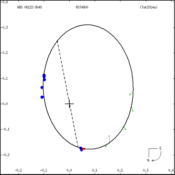
Measures: green=micrometric, blue=interferometric, purple=photographic |
|
WDS 06122-3645 RST 4800 (HD 43011) : NOTES
No records found.
REFERENCES
| refcode |
metd |
author |
reference |
| Tok2014a |
orb j |
Tokovinin, A., Mason, B.D., & Hartkopf, W.I. |
2014AJ....147..123T |
| Tok2014a |
+St |
AJ 147, 123, 2014 (some measures corrected in Tok2017b) |
2017AJ....154..110T |
DISCOVERER
| idgroup |
discov |
author |
| 1 |
RST |
Rossiter, R.A. |
WDS HISTORIC DATA
| coord_2000 |
discov_num |
comp |
epoch |
obs |
pa |
sep |
mag_pri |
mag_sec |
spectr |
notes |
coord_arcsec_2000 |
| 06122-3645 |
RST4800 |
|
1991 |
9 |
17 |
0.2 |
9.90 |
10.26 |
G5V |
O |
061214.17-364522.8 |
| 06122-3645 |
RST4800 |
|
2008 |
10 |
256 |
0.1 |
9.90 |
10.26 |
G5V |
O |
061214.17-364522.8 |
| 06122-3645 |
RST4800 |
|
2011 |
11 |
239 |
0.1 |
9.90 |
10.26 |
G5V |
O |
061214.17-364522.8 |
| 06122-3645 |
RST4800 |
|
2013 |
12 |
226 |
0.1 |
9.90 |
10.26 |
G5V |
O |
061214.17-364522.8 |
| 06122-3645 |
RST4800 |
|
2014 |
14 |
221 |
0.2 |
9.90 |
10.26 |
G5V |
O |
061214.17-364522.8 |
| 06122-3645 |
RST4800 |
|
2018 |
15 |
204 |
0.2 |
9.90 |
10.26 |
G5V |
O |
061214.17-364522.8 |
If you need more information about this double, apply for a
data request form to the WDS.
WDS 06122-3645 RST 4800 (HD 43011) : VISUAL OBSERVATIONS REPORTS
No records found.
WDS 06122-3645 RST 4800 (HD 43011) : MEASURES
No records found.
WDS 06122-3645 (HD 43011) : VIRTUAL EYEPIECE

Click on the map to see the double of your interest.
Pass over with the mouse cursor to display the catalog designation.
|
|
WDS 06122-3645 (HD 43011) : ALADIN DSS IMAGE @ 06h 12m 14.17s -36° 45' 22.8"
WDS 06122-3645 RST 4800 (HD 43011) : NEIGHBORHOODS
|
|

Click on the map to see the double of your interest.
Pass over with the mouse cursor to display the catalog designation.
|
| Show |
name |
coord_2000 |
discov# |
comp |
pa |
sep |
dist(') |
| Show |
|
06122-3645 |
RST4800 |
|
204 |
0.2 |
|
| Show |
|
06130-3701 |
BRT1592 |
|
166 |
3.8 |
18 |
| Show |
|
06147-3657 |
RST4803 |
|
100 |
0.4 |
33 |
| Show |
|
06147-3709 |
TDS3660 |
|
108 |
0.8 |
38 |
| Show |
|
06094-3707 |
KPP3660 |
|
295 |
3.5 |
41 |
| Show |
|
06167-3648 |
RST4804 |
|
257 |
0.7 |
54 |
| Show |
|
06073-3702 |
RSS 98 |
|
42 |
9.0 |
62 |
| Show |
|
06093-3550 |
WHH 1 |
AB |
243 |
3.1 |
67 |
| Show |
|
06093-3550 |
WHH 1 |
AC |
276 |
5.3 |
67 |
| Show |
|
06172-3715 |
EHR 8 |
|
228 |
0.0 |
67 |
| Show |
|
06130-3539 |
TDS3632 |
|
3 |
1.5 |
67 |
| Show |
|
06103-3756 |
NSN 74 |
|
212 |
22.0 |
75 |
| Show |
|
06119-3529 |
VSP 17 |
|
173 |
0.1 |
77 |
| Show |
|
06115-3529 |
CRI 10 |
|
326 |
38.1 |
77 |
| Show |
|
06106-3800 |
TDS3607 |
|
323 |
1.4 |
78 |
| Show |
|
06125-3515 |
HDS 849 |
|
296 |
0.2 |
91 |
| Show |
|
06058-3554 |
KPP 551 |
|
196 |
5.2 |
93 |
| Show |
|
06203-3611 |
TDS3750 |
|
167 |
1.9 |
104 |
| Show |
|
06198-3553 |
TVB 127 |
AB |
183 |
7.8 |
106 |
| Show |
|
06166-3818 |
TDS3689 |
|
221 |
0.8 |
107 |
| Show |
|
06209-3623 |
RST4805 |
|
46 |
0.2 |
107 |
| Show |
|
06163-3833 |
DAM1344 |
|
61 |
26.8 |
119 |
| Show |
|
06161-3835 |
COO 35 |
|
229 |
6.2 |
119 |
| Show |
|
06093-3842 |
LDS 154 |
|
53 |
38.0 |
123 |
| Show |
|
06223-3717 |
UC 1428 |
|
176 |
21.1 |
125 |
| Show |
|
06079-3839 |
HDS 835 |
|
54 |
0.2 |
125 |
| Show |
|
06100-3848 |
RST1302 |
|
330 |
0.8 |
126 |
| Show |
|
06032-3758 |
BVD 91 |
|
56 |
46.1 |
130 |
| Show |
|
06140-3437 |
NSN 75 |
|
107 |
2.4 |
131 |
| Show |
|
06019-3607 |
TDS3504 |
|
322 |
0.6 |
131 |
| Show |
|
06033-3524 |
JSP 90 |
|
328 |
1.3 |
135 |
| Show |
|
06011-3704 |
B 1045 |
|
192 |
0.9 |
136 |
| Show |
|
06173-3443 |
RSS 105 |
|
352 |
7.0 |
137 |
| Show |
|
06087-3856 |
TDS3585 |
|
61 |
0.8 |
137 |
| Show |
|
06232-3608 |
JSP 100 |
|
226 |
2.3 |
138 |
| Show |
|
06240-3642 |
HJ 3857 |
AB |
255 |
13.0 |
142 |
| Show |
|
06240-3642 |
DUN 28 |
AC |
74 |
63.6 |
142 |
| Show |
|
06205-3828 |
I 1496 |
|
218 |
2.4 |
143 |
| Show |
|
06004-3702 |
HDS 818 |
|
295 |
0.6 |
143 |
| Show |
|
06074-3433 |
TDS3570 |
|
327 |
0.9 |
145 |
| Show |
|
06212-3507 |
SWR 10 |
|
109 |
25.5 |
147 |
| Show |
|
06021-3813 |
RST1299 |
|
220 |
0.7 |
149 |
| Show |
|
05599-3703 |
B 1044 |
AB |
260 |
21.3 |
149 |
| Show |
|
05599-3703 |
B 1044 |
AC |
265 |
24.9 |
149 |
| Show |
|
05599-3703 |
B 1044 |
AD |
190 |
27.3 |
149 |
| Show |
|
06096-3420 |
TDS3594 |
|
8 |
1.2 |
149 |
| Show |
|
05599-3703 |
B 1044 |
BC |
297 |
4.4 |
150 |
| Show |
|
06017-3527 |
JSP 88 |
|
113 |
0.4 |
150 |
| Show |
|
06110-3413 |
JSP 94 |
|
190 |
2.0 |
153 |
| Show |
|
05592-3704 |
TVB 111 |
|
251 |
14.5 |
158 |
| Show |
|
06096-3411 |
HDS 840 |
|
125 |
0.1 |
158 |
|
|
WDS 06122-3645 : COMPONENTS
06122-3645 A
| Componente originario normalizzato |
AB |
|
Name |
HD 43011 |
|
Coord arcsec 2000 |
061214.17-364522.8 |
|
Mag |
9.9 |
|
| Spectral class |
G5V (yellow) |
|
PmRA |
30.00 |
|
PmDE |
-91.0 |
|
SAO |
196582 |
|
| HIP |
29443 |
|
Tycho2 |
7084-01327-1 |
|
HD |
43011 |
|
CD |
CD-36 2709 |
|
| CP |
CP-36 891 |
|
| Tycho2 |
7084-01327-1 |
|
Pflag |
|
|
RAmdeg |
93.05918327 |
|
DEmdeg |
-36.75655109 |
|
| PmRA |
40.6 |
|
PmDE |
-86.9 |
|
E RAmdeg |
12 |
|
E DEmdeg |
13 |
|
| E pmRA |
1.4 |
|
E pmDE |
1.4 |
|
EpRAm |
1989.09 |
|
EpDEm |
1988.80 |
|
| Num |
8 |
|
Q RAmdeg |
1.2 |
|
Q DEmdeg |
1.5 |
|
Q pmRA |
1.2 |
|
| Q pmDE |
1.5 |
|
BTmag |
9.995 |
|
E BTmag |
0.026 |
|
VTmag |
9.241 |
|
| E VTmag |
0.019 |
|
Prox |
999 |
|
TYC |
T |
|
HIP |
29443 |
|
| CCDM |
AS |
|
RAdeg |
93.05906389 |
|
DEdeg |
-36.75634833 |
|
EpRA 1990 |
1.61 |
|
| EpDE 1990 |
1.63 |
|
E RAdeg |
13.4 |
|
E DEdeg |
13.6 |
|
Posflg |
P |
|
| Corr |
0.0 |
|
| SAO |
196582 |
|
DelFlag |
|
|
RA1950 |
|
|
PmRA1950 |
0.0008 |
|
| DE1950 |
|
|
PmDE1950 |
-0.096 |
|
Vmag |
9.2 |
|
SpType |
G0 |
|
| Double code |
|
|
Source |
41 |
|
CatNum |
2308 |
|
DM |
CD-36 2709 |
|
| DMcomp |
|
|
BDsup |
|
|
HD |
43011 |
|
M HD |
0 |
|
| GC |
|
|
RA1950rad |
1.61661781 |
|
DE1950rad |
-0.64126196 |
|
PmRA2000 |
0.0013 |
|
| PmDE2000 |
-0.095 |
|
| Catalog |
H |
|
HIP |
29443 |
|
Proxy |
H |
|
RAhms |
06 12 14.17 |
|
| DEdms |
-36 45 22.8 |
|
Vmag |
9.17 |
|
VarFlag |
|
|
R Vmag |
H |
|
| RAdeg |
93.0591 |
|
DEdeg |
-36.7563 |
|
AstroRef |
* |
|
Plx |
5.19 |
|
| CCDM |
06122-3645 |
|
N CCDM |
I |
|
Nsys |
1 |
|
Ncomp |
2 |
|
| MultFlag |
C |
|
Source |
S |
|
Qual |
A |
|
M HIP |
AS |
|
| Theta |
17 |
|
Rho |
0.185 |
|
HD |
43011 |
|
BD |
|
|
| CD |
CD-36 2709 |
|
CP |
CP-36 891 |
|
Dm number |
-36 2709 |
|
VIred |
0.73 |
|
| SpType |
G5V |
|
R SpType |
|
|
Coord arcsec 2000 |
061214.17-364522.8 |
|
| HIP |
29443 |
|
Sn |
55 |
|
So |
3 |
|
Nc |
2 |
|
| RArad |
1.6241870069 |
|
DErad |
-0.641519196 |
|
Plx |
5.95 |
|
PmRA |
42.41 |
|
| PmDE |
-89.47 |
|
E RArad |
0.7 |
|
E DErad |
0.91 |
|
E Plx |
0.95 |
|
| E pmRA |
0.69 |
|
E pmDE |
1.06 |
|
Hpmag |
9.3084 |
|
E Hpmag |
0.0024 |
|
| SHp |
0.021 |
|
VA |
0 |
|
BV |
0.651 |
|
E BV |
0.025 |
|
| VI |
0.71 |
|
| Ccdm |
06122-3645 |
|
RComp |
|
|
Comp |
A |
|
Note1 |
|
|
| Note2 |
|
|
Discov num |
|
|
DRAs |
2.05 |
|
DDEs |
-24.1 |
|
| R dRAs |
10 |
|
Year |
|
|
Theta |
|
|
Rho |
|
|
| Obs |
2 |
|
Vmag |
9.9 |
|
Sp |
G0 |
|
PmNote |
* |
|
| PmRA |
10 |
|
PmDE |
-96 |
|
Dm number |
-36 2709 |
|
Cat1 |
CD |
|
| Name2 |
196582 |
|
Cat2 |
SAO |
|
HD |
43011 |
|
M HD |
|
|
| ADS BDS |
|
|
M ADS BDS |
|
|
N IDS |
|
|
IDS |
06088S3644A |
|
| HIC |
29443 |
|
06122-3645 B
| Componente originario normalizzato |
AB |
|
Coord arcsec 2000 |
061214.16-364523.0 |
|
Mag |
10.26 |
|
Calc delta mag |
0.36 |
|
| Calc coord |
yes |
|
| Ccdm |
06122-3645 |
|
RComp |
|
|
Comp |
B |
|
Note1 |
|
|
| Note2 |
|
|
Discov num |
RST4800 |
|
DRAs |
|
|
DDEs |
|
|
| R dRAs |
|
|
Year |
1951 |
|
Theta |
084 |
|
Rho |
0.2 |
|
| Obs |
2 |
|
Vmag |
9.9 |
|
Sp |
|
|
PmNote |
|
|
| PmRA |
|
|
PmDE |
|
|
Dm number |
|
|
Cat1 |
|
|
| Name2 |
|
|
Cat2 |
|
|
HD |
|
|
M HD |
|
|
| ADS BDS |
|
|
M ADS BDS |
|
|
N IDS |
|
|
IDS |
06088S3644B |
|
| HIC |
29443 |
|