02005+5939 UR 12
02h 00m 31.66s +59° 39' 09.4" P.A. 278.00 sep 5.9 mag 9.10,14.00 Sp G7V
| Coord 2000 |
02005+5939 |
|
Discov num |
UR 12 |
|
Comp |
|
|
Coord arcsec 2000 |
02 00 31.66 +59 39 09.4 |
|
| Date first |
2000 |
|
Date last |
2016 |
|
Obs |
7 |
|
| Pa first |
277 |
|
Pa last |
277.9 |
|
P.A. Now (θ) |
277.9° |
|
| Sep first |
5.8 |
|
Sep last |
5.876 |
|
Sep. Now (ρ) |
5.876" |
|
| Mag pri |
9.10 |
|
Mag sec |
14.00 |
|
delta mag (ΔM) |
4.9 |
|
Spectral class |
G7V (yellow) |
|
| Pri motion ra |
-150 |
|
Sec motion ra |
-160 |
|
| Pri motion dec |
-115 |
|
Sec motion dec |
-111 |
|
| Notes |
V
(Proper motion indicates physical) |
|
rPM=0.055 (< 0.3, Physical double)
This double is physical.
OTHER CATALOGS AND DESIGNATIONS
| Constellation |
Cassiopeia |
|
SAO |
22831 |
|
Tycho2 |
3697-02219-1 |
|
Gaia DR2 |
507836421987745536 |
|
| HD |
12088 |
|
WDS 02005+5939 UR 12 : NOTES
No records found.
REFERENCES
| refcode |
metd |
author |
reference |
| UR |
|
USNO Robotic Astrometric Telescope (URAT) |
................... |
| UR |
|
(Note: A preliminary reduction of the first 2 years of URAT data is expected to be |
|
| UR |
|
released in early 2015. However, any extraction of relative astrometry from URAT |
|
| UR |
|
before the final data reduction would be premature. Accordingly, as was done with |
|
| UR |
|
UCAC, no URAT-based measures will be added to the WDS database until the final |
|
| UR |
|
version of the catalog has been released.) |
|
| UR_2015 |
Er j |
Zacharias, N., Finch, C., Subasavage, J., Bredthauer, G., Crockett, C., |
2015AJ....150..101Z |
| UR_2015 |
|
Divittorio, M., Ferguson, E., Harris, F., Harris, H., Henden, A., Kilian, C., |
|
| UR_2015 |
|
Munn, J., Rafferty, T., Rhodes, A., Schultheiss, M., Tilleman, T., & Wieder, G. |
|
| UR_2016 |
Er+ - |
Finch, C.T. & Zacharias, N. |
2016AJ....151..160F |
| UR_2016 |
+not |
AJ 151, 160, 2017 |
|
WDS HISTORIC DATA
| coord_2000 |
discov_num |
comp |
epoch |
obs |
pa |
sep |
mag_pri |
mag_sec |
spectr |
notes |
coord_arcsec_2000 |
| 02005+5939 |
UR 12 |
|
2013 |
3 |
278 |
5.7 |
9.10 |
14.00 |
G7V |
V |
020031.66+593909.4 |
| 02005+5939 |
UR 12 |
|
2015 |
4 |
278 |
5.9 |
9.10 |
14.00 |
G7V |
V |
020031.66+593909.4 |
| 02005+5939 |
UR 12 |
|
2016 |
7 |
278 |
5.9 |
9.10 |
14.00 |
G7V |
V |
020031.66+593909.4 |
If you need more information about this double, apply for a
data request form to the WDS.
WDS 02005+5939 UR 12 : VISUAL OBSERVATIONS REPORTS
No records found.
WDS 02005+5939 UR 12 : MEASURES
No records found.
WDS 02005+5939 : VIRTUAL EYEPIECE
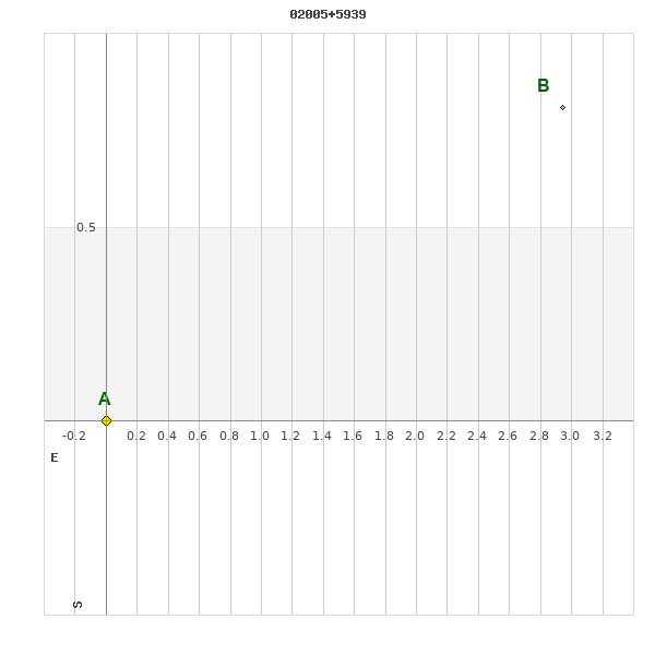
Click on the map to see the double of your interest.
Pass over with the mouse cursor to display the catalog designation.
|
|
WDS 02005+5939 : ALADIN DSS IMAGE @ 02h 00m 31.66s +59° 39' 09.4"
WDS 02005+5939 UR 12 : NEIGHBORHOODS
|
|
Click on the map to see the double of your interest.
Pass over with the mouse cursor to display the catalog designation.
|
| Show |
name |
coord_2000 |
discov# |
comp |
pa |
sep |
dist(') |
| Show |
|
02005+5939 |
UR 12 |
|
278 |
5.9 |
|
| Show |
|
01599+5943 |
TDS2083 |
|
337 |
2.6 |
6 |
| Show |
|
01583+5937 |
FRK 3 |
|
224 |
44.3 |
17 |
| Show |
|
02008+5958 |
HDS 269 |
|
229 |
0.1 |
19 |
| Show |
|
01581+5928 |
TDS2069 |
|
227 |
2.3 |
22 |
| Show |
|
01589+6010 |
HJ 1098 |
|
351 |
18.4 |
34 |
| Show |
|
01581+5907 |
STI1735 |
AB |
349 |
9.9 |
38 |
| Show |
|
01581+5907 |
DAM 771 |
AC |
325 |
8.4 |
38 |
| Show |
|
02056+5945 |
KPP3148 |
|
16 |
4.1 |
40 |
| Show |
|
01551+5938 |
TDS2053 |
|
333 |
1.1 |
42 |
| Show |
|
01565+5912 |
MLR 486 |
|
188 |
0.5 |
42 |
| Show |
|
02031+5902 |
TDS 67 |
|
255 |
1.1 |
43 |
| Show |
|
01551+5958 |
A 955 |
|
111 |
1.1 |
46 |
| Show |
|
01562+5908 |
STI1718 |
|
80 |
8.9 |
46 |
| Show |
|
02009+6025 |
A 956 |
|
132 |
0.5 |
47 |
| Show |
|
01546+5956 |
A 953 |
|
62 |
0.8 |
48 |
| Show |
|
01545+5954 |
HDS 259 |
|
212 |
16.5 |
48 |
| Show |
|
02033+6022 |
STI 338 |
|
324 |
4.5 |
48 |
| Show |
|
02037+5858 |
STI1768 |
|
251 |
16.2 |
48 |
| Show |
|
01565+5900 |
MLB 48 |
|
77 |
1.3 |
50 |
| Show |
|
02020+6028 |
SKF2784 |
|
247 |
33.8 |
50 |
| Show |
|
02013+6031 |
STF 193 |
DE |
204 |
2.5 |
52 |
| Show |
|
01559+6020 |
TDS2056 |
|
287 |
0.5 |
54 |
| Show |
|
02006+5842 |
STI1754 |
|
6 |
12.2 |
57 |
| Show |
|
01566+5850 |
STI1722 |
|
91 |
15.2 |
58 |
| Show |
|
01545+6016 |
STI 320 |
|
354 |
12.3 |
59 |
| Show |
|
01538+5911 |
STI1709 |
|
101 |
11.0 |
59 |
| Show |
|
02048+6030 |
A 957 |
|
357 |
0.4 |
61 |
| Show |
|
01561+6035 |
AG 301 |
|
262 |
8.6 |
65 |
| Show |
|
02007+5832 |
STF 192 |
AB |
181 |
4.9 |
68 |
| Show |
|
02007+5832 |
STF 192 |
AC |
149 |
72.1 |
68 |
| Show |
|
01594+5831 |
LAF 26 |
AB |
88 |
3.6 |
69 |
| Show |
|
01594+5831 |
LAF 26 |
AC |
35 |
5.5 |
69 |
| Show |
|
01594+5831 |
LAF 26 |
AD |
157 |
6.3 |
69 |
| Show |
|
01594+5831 |
LAF 26 |
AE |
228 |
6.3 |
69 |
| Show |
|
01594+5831 |
LAF 26 |
AF |
307 |
6.4 |
69 |
| Show |
|
01594+5831 |
LAF 26 |
AG |
106 |
6.8 |
69 |
| Show |
|
01594+5831 |
LAF 26 |
AH |
106 |
6.8 |
69 |
| Show |
|
01594+5831 |
LAF 26 |
AI |
5 |
7.8 |
69 |
| Show |
|
01594+5831 |
LAF 26 |
AJ |
117 |
7.6 |
69 |
| Show |
|
01594+5831 |
LAF 26 |
AK |
316 |
8.8 |
69 |
| Show |
|
01594+5831 |
LAF 26 |
AL |
319 |
9.7 |
69 |
| Show |
|
01594+5831 |
LAF 26 |
AM |
334 |
9.7 |
69 |
| Show |
|
01594+5831 |
LAF 26 |
AN |
228 |
11.4 |
69 |
| Show |
|
01594+5831 |
RAO 535 |
AO |
24 |
1.7 |
69 |
| Show |
|
02018+5831 |
STI1764 |
|
291 |
12.7 |
69 |
| Show |
|
02035+6044 |
STI 339 |
|
104 |
7.8 |
69 |
| Show |
|
02089+5910 |
CRB 160 |
|
42 |
31.2 |
71 |
| Show |
|
02098+5935 |
STI 346 |
|
118 |
15.3 |
71 |
| Show |
|
01511+5928 |
TDS2022 |
|
313 |
0.5 |
73 |
| Show |
|
01508+5939 |
MLB 47 |
CD |
299 |
5.2 |
73 |
|
|
WDS 02005+5939 : COMPONENTS
02005+5939 A
| Componente originario normalizzato |
AB |
|
Coord arcsec 2000 |
020031.66+593909.4 |
|
Mag |
9.1 |
|
Spectral class |
G7V (yellow) |
|
| PmRA |
-150.00 |
|
PmDE |
-115.0 |
|
SAO |
22831 |
|
Tycho2 |
3697-02219-1 |
|
| HD |
12088 |
|
DM |
BD+58 350 |
|
| Tycho2 |
3697-02219-1 |
|
Pflag |
|
|
RAmdeg |
30.13189802 |
|
DEmdeg |
59.65261986 |
|
| PmRA |
-150.1 |
|
PmDE |
-114.7 |
|
E RAmdeg |
11 |
|
E DEmdeg |
12 |
|
| E pmRA |
1.6 |
|
E pmDE |
1.7 |
|
EpRAm |
1990.39 |
|
EpDEm |
1990.31 |
|
| Num |
7 |
|
Q RAmdeg |
1.2 |
|
Q DEmdeg |
1.3 |
|
Q pmRA |
1.1 |
|
| Q pmDE |
1.3 |
|
BTmag |
9.996 |
|
E BTmag |
0.026 |
|
VTmag |
9.159 |
|
| E VTmag |
0.018 |
|
Prox |
316 |
|
TYC |
T |
|
HIP |
|
|
| CCDM |
|
|
RAdeg |
30.13258417 |
|
DEdeg |
59.65287917 |
|
EpRA 1990 |
1.72 |
|
| EpDE 1990 |
1.79 |
|
E RAdeg |
12.2 |
|
E DEdeg |
12.9 |
|
Posflg |
|
|
| Corr |
0.2 |
|
| SAO |
22831 |
|
DelFlag |
|
|
RA1950 |
|
|
PmRA1950 |
-0.022 |
|
| DE1950 |
|
|
PmDE1950 |
-0.109 |
|
Vmag |
9 |
|
SpType |
G5 |
|
| Double code |
|
|
Source |
38 |
|
CatNum |
1766 |
|
DM |
BD+58 350 |
|
| DMcomp |
|
|
BDsup |
|
|
HD |
12088 |
|
M HD |
0 |
|
| GC |
|
|
RA1950rad |
0.51069698 |
|
DE1950rad |
1.0369426 |
|
PmRA2000 |
-0.0223 |
|
| PmDE2000 |
-0.113 |
|
02005+5939 B
| Componente originario normalizzato |
AB |
|
Coord arcsec 2000 |
020031.27+593910.2 |
|
Mag |
14 |
|
PmRA |
-160.00 |
|
| PmDE |
-111.0 |
|
Calc delta mag |
4.9 |
|
Calc coord |
yes |
|