13548-0243 GWP 2135 AC
13h 54m 45.33s -02° 43' 07.0" P.A. 53.00 sep 285.9 mag 12.50,16.40
| Coord 2000 |
13548-0243 |
|
Discov num |
GWP2135 |
|
Comp |
AC |
|
Coord arcsec 2000 |
13 54 45.33 -02 43 07.0 |
|
| Date first |
1995 |
|
Date last |
2015 |
|
Obs |
7 |
|
| Pa first |
53 |
|
Pa last |
52.9 |
|
P.A. Now (θ) |
52.9° |
|
| Sep first |
285.0 |
|
Sep last |
285.923 |
|
Sep. Now (ρ) |
285.923" |
|
| Mag pri |
12.50 |
|
Mag sec |
16.40 |
|
delta mag (ΔM) |
3.9 |
|
Spectral class |
|
|
| Pri motion ra |
-034 |
|
Sec motion ra |
-022 |
|
| Pri motion dec |
-062 |
|
Sec motion dec |
-058 |
|
| Notes |
V
R
(Proper motion indicates physical, Red magnitudes) |
|
rPM=0.179 (< 0.3, Physical double)
This double is physical.
13548-0243 SYSTEM COMPONENTS
| Show |
name |
SAO |
coord |
wds_name |
last |
obs |
pa |
sep |
mag1 |
mag2 |
d_mag |
orb |
current |
| Show |
|
|
13 54 45 -02 43 07 |
GWP 2134 AB |
2015 |
8 |
55 |
218.4 |
12.50 |
13.00 |
0.50 |
|
|
| Show |
|
|
13 54 45 -02 43 07 |
GWP 2135 AC |
2015 |
7 |
53 |
285.9 |
12.50 |
16.40 |
3.90 |
|
<=== |
Triple system
3 estimated visually detectable stars in this system
OTHER CATALOGS AND DESIGNATIONS
| Constellation |
Virgo |
|
Tycho2 |
4971-00043-1 |
|
Gaia DR2 |
3657786739902764800 |
|
WDS 13548-0243 GWP 2135 AC : NOTES
No records found.
REFERENCES
| refcode |
metd |
author |
reference |
| GWP |
|
Garraf Wide Pairs: CPM wide pairs (>50mas/y) discovered in the Garraf Astronomical |
|
| GWP |
|
Observatory (OAG) CPMWP Survey |
|
| GWP |
|
Part I (2012): Measures of 1725 pairs. Equatorial zone |
|
| GWP |
|
(RA 00h00m to 11h59m, DEC +20 to -20 deg) |
|
| GWP |
|
Garraf Wide Pairs: CPM wide pairs (>50mas/y) discovered in the Garraf Astronomical |
|
| GWP |
|
Observatory (OAG) CPMWP Survey |
|
| GWP |
|
Part II (2016): Measures of 1657 pairs. Equatorial zone |
|
| GWP |
|
(RA 12h00m to 23h59m, DEC +20 to -20 deg) |
|
WDS HISTORIC DATA
| coord_2000 |
discov_num |
comp |
epoch |
obs |
pa |
sep |
mag_pri |
mag_sec |
spectr |
notes |
coord_arcsec_2000 |
| 13548-0243 |
GWP2135 |
AC |
1999 |
3 |
53 |
285.7 |
12.50 |
16.40 |
|
V R |
135445.33-024307.0 |
| 13548-0243 |
GWP2135 |
AC |
2015 |
4 |
53 |
285.9 |
12.50 |
16.40 |
|
V R |
135445.33-024307.0 |
If you need more information about this double, apply for a
data request form to the WDS.
WDS 13548-0243 GWP 2135 AC : VISUAL OBSERVATIONS REPORTS
No records found.
WDS 13548-0243 GWP 2135 AC : MEASURES
No records found.
WDS 13548-0243 : VIRTUAL EYEPIECE
Click on the map to see the double of your interest.
Pass over with the mouse cursor to display the catalog designation.
|
|
WDS 13548-0243 : ALADIN DSS IMAGE @ 13h 54m 45.33s -02° 43' 07.0"
WDS 13548-0243 GWP 2135 AC : NEIGHBORHOODS
|
|
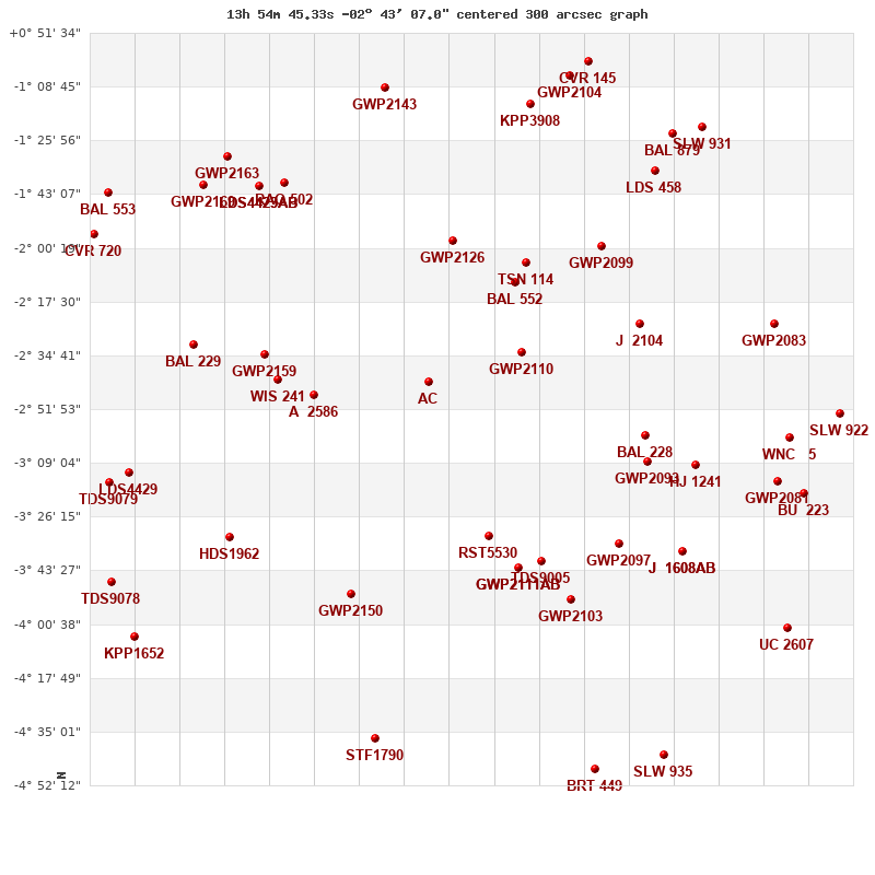
Click on the map to see the double of your interest.
Pass over with the mouse cursor to display the catalog designation.
|
| Show |
name |
coord_2000 |
discov# |
comp |
pa |
sep |
dist(') |
| Show |
|
13548-0243 |
GWP2134 |
AB |
55 |
218.4 |
|
| Show |
|
13548-0243 |
GWP2135 |
AC |
53 |
285.9 |
|
| Show |
|
13524-0234 |
GWP2110 |
|
304 |
371.7 |
37 |
| Show |
|
13577-0247 |
A 2586 |
|
322 |
0.3 |
44 |
| Show |
|
13526-0212 |
BAL 552 |
|
95 |
14.5 |
46 |
| Show |
|
13541-0158 |
GWP2126 |
|
178 |
89.1 |
47 |
| Show |
|
13523-0205 |
TSN 114 |
|
29 |
548.8 |
54 |
| Show |
|
13532-0333 |
RST5530 |
|
21 |
0.9 |
55 |
| Show |
|
13586-0242 |
WIS 241 |
|
308 |
760.3 |
58 |
| Show |
|
13591-0235 |
GWP2159 |
|
99 |
134.3 |
64 |
| Show |
|
13524-0343 |
GWP2111 |
AB |
233 |
25.4 |
69 |
| Show |
|
13524-0343 |
GWP2112 |
AC |
311 |
330.9 |
69 |
| Show |
|
13519-0341 |
TDS9005 |
|
269 |
0.5 |
72 |
| Show |
|
13567-0351 |
GWP2150 |
|
42 |
8.5 |
75 |
| Show |
|
13503-0200 |
GWP2099 |
|
278 |
330.8 |
80 |
| Show |
|
13494-0224 |
J 2104 |
|
160 |
8.9 |
84 |
| Show |
|
13584-0140 |
RAO 502 |
|
-1 |
0.2 |
84 |
| Show |
|
13492-0300 |
BAL 228 |
|
320 |
19.9 |
85 |
| Show |
|
13492-0309 |
GWP2093 |
|
177 |
6.4 |
88 |
| Show |
|
13511-0353 |
GWP2103 |
|
322 |
8.8 |
89 |
| Show |
|
13499-0335 |
GWP2097 |
|
126 |
24.9 |
90 |
| Show |
|
13591-0140 |
LDS4423 |
AB |
77 |
2.6 |
90 |
| Show |
|
13591-0140 |
LDS4423 |
AC |
256 |
45.5 |
90 |
| Show |
|
14008-0232 |
BAL 229 |
|
73 |
17.6 |
91 |
| Show |
|
13598-0333 |
HDS1962 |
|
48 |
0.1 |
91 |
| Show |
|
13558-0109 |
GWP2143 |
|
342 |
5.1 |
96 |
| Show |
|
13522-0114 |
KPP3908 |
|
96 |
1.8 |
97 |
| Show |
|
13599-0131 |
GWP2163 |
|
135 |
513.0 |
106 |
| Show |
|
13479-0310 |
HJ 1241 |
|
139 |
20.3 |
106 |
| Show |
|
14005-0140 |
GWP2169 |
|
154 |
6.4 |
107 |
| Show |
|
13490-0136 |
LDS 458 |
|
21 |
15.8 |
110 |
| Show |
|
13483-0338 |
J 1608 |
AB |
249 |
6.7 |
112 |
| Show |
|
13483-0338 |
J 1608 |
AC |
257 |
25.7 |
112 |
| Show |
|
13511-0105 |
GWP2104 |
|
29 |
49.8 |
112 |
| Show |
|
13561-0437 |
STF1790 |
|
62 |
5.8 |
116 |
| Show |
|
14024-0311 |
LDS4429 |
|
220 |
28.1 |
119 |
| Show |
|
13507-0101 |
CVR 145 |
|
99 |
23.7 |
120 |
| Show |
|
13485-0124 |
BAL 879 |
|
143 |
7.1 |
123 |
| Show |
|
14029-0315 |
TDS9079 |
|
98 |
0.6 |
127 |
| Show |
|
13478-0122 |
SLW 931 |
|
74 |
12.3 |
133 |
| Show |
|
13459-0225 |
GWP2083 |
|
174 |
15.4 |
134 |
| Show |
|
14033-0156 |
CVR 720 |
|
163 |
12.2 |
137 |
| Show |
|
14029-0143 |
BAL 553 |
|
2 |
20.4 |
137 |
| Show |
|
14028-0347 |
TDS9078 |
|
291 |
0.5 |
137 |
| Show |
|
13458-0315 |
GWP2081 |
|
324 |
26.2 |
138 |
| Show |
|
14023-0405 |
KPP1652 |
|
128 |
12.7 |
139 |
| Show |
|
13505-0447 |
BRT 449 |
|
53 |
4.4 |
140 |
| Show |
|
13455-0301 |
WNC 5 |
|
163 |
4.0 |
140 |
| Show |
|
13452-0319 |
BU 223 |
|
343 |
18.9 |
148 |
| Show |
|
13487-0442 |
SLW 935 |
|
358 |
137.1 |
150 |
| Show |
|
13442-0253 |
SLW 922 |
|
158 |
176.5 |
158 |
|
|
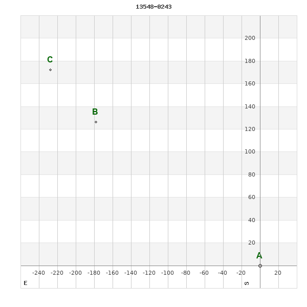
WDS 13548-0243 : COMPONENTS
| |
A |
B |
| B |
pa=54.7°
sep=218.29"
| |
| C |
pa=52.9°
sep=285.72"
| pa=47.1°
sep=67.89"
|
13548-0243 A
| Coord arcsec 2000 |
135445.33-024307.0 |
|
Mag |
12.5 |
|
PmRA |
-34.00 |
|
PmDE |
-62.0 |
|
| Tycho2 |
4971-00043-1 |
|
| Tycho2 |
4971-00043-1 |
|
Pflag |
|
|
RAmdeg |
208.68886398 |
|
DEmdeg |
-2.71860701 |
|
| PmRA |
-33.7 |
|
PmDE |
-60.9 |
|
E RAmdeg |
66 |
|
E DEmdeg |
66 |
|
| E pmRA |
2.0 |
|
E pmDE |
2.0 |
|
EpRAm |
1971.40 |
|
EpDEm |
1969.56 |
|
| Num |
4 |
|
Q RAmdeg |
0.8 |
|
Q DEmdeg |
0.6 |
|
Q pmRA |
0.8 |
|
| Q pmDE |
0.6 |
|
BTmag |
12.582 |
|
E BTmag |
0.265 |
|
VTmag |
12.564 |
|
| E VTmag |
0.287 |
|
Prox |
999 |
|
TYC |
|
|
HIP |
|
|
| CCDM |
|
|
RAdeg |
208.68893389 |
|
DEdeg |
-2.71848917 |
|
EpRA 1990 |
1.73 |
|
| EpDE 1990 |
1.51 |
|
E RAdeg |
108.7 |
|
E DEdeg |
141.6 |
|
Posflg |
|
|
| Corr |
0.0 |
|
13548-0243 B
| Coord arcsec 2000 |
135457.22-024100.8 |
|
Mag |
13 |
|
PmRA |
0.00 |
|
PmDE |
0.0 |
|
| Calc delta mag |
0.5 |
|
Calc coord |
yes |
|
13548-0243 C
| Coord arcsec 2000 |
135500.53-024014.5 |
|
Mag |
16.4 |
|
PmRA |
-22.00 |
|
PmDE |
-58.0 |
|
| Calc delta mag |
3.9 |
|
Calc coord |
yes |
|