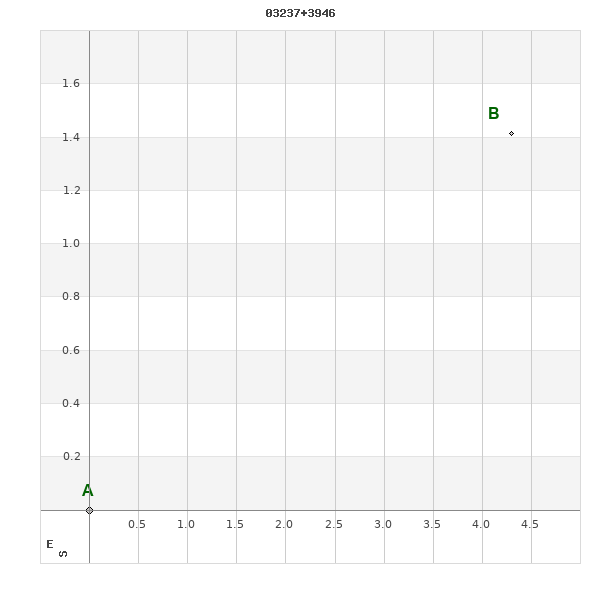
03237+3946 ALI 1033
03h 23m 41.26s +39° 45' 36.9" P.A. 284.00 sep 5.8 mag 11.94,13.20
| Coord 2000 |
03237+3946 |
|
Discov num |
ALI1033 |
|
Comp |
|
|
Coord arcsec 2000 |
03 23 41.26 +39 45 36.9 |
|
| Date first |
1928 |
|
Date last |
2016 |
|
Obs |
5 |
|
| Pa first |
287 |
|
Pa last |
284.2 |
|
P.A. Now (θ) |
284.2° |
|
| Sep first |
6.5 |
|
Sep last |
5.76 |
|
Sep. Now (ρ) |
5.76" |
|
| Mag pri |
11.94 |
|
Mag sec |
13.20 |
|
delta mag (ΔM) |
1.26 |
|
Spectral class |
|
|
| Pri motion ra |
+005 |
|
Sec motion ra |
-028 |
|
| Pri motion dec |
-005 |
|
Sec motion dec |
+001 |
|
| Notes |
|
|
rPM=1.197
This double is not physical.
OTHER CATALOGS AND DESIGNATIONS
| Constellation |
Perseus |
|
Tycho2 |
2865-01377-1 |
|
Gaia DR2 |
235945780752775296 |
|
WDS 03237+3946 ALI 1033 : NOTES
No records found.
REFERENCES
| refcode |
metd |
author |
reference |
| Ali1949 |
Pa - |
Ali, A. |
1949AJ.....54..199A |
| Ali1949 |
|
AJ 54, 199, 1949 |
|
| Ali1950 |
Pa - |
Ali, A. |
1950AJ.....55..209A |
| Ali1950 |
|
AJ 55, 208, 1950 |
|
| Ali1952 |
Pa - |
Ali, A. |
1952AJ.....57..146A |
| Ali1952 |
|
AJ 57, 146, 1952 |
|
| Ali1955 |
Pa - |
Ali, A. |
. |
| Ali1955 |
|
Pub. Nizamiah Obs. 13, Pt. 2, 1955 |
|
| Ali9999 |
Pa - |
Ali, A. |
................... |
| Ali9999 |
+Po |
Unpublished, manuscript or reference not found. |
|
WDS HISTORIC DATA
| coord_2000 |
discov_num |
comp |
epoch |
obs |
pa |
sep |
mag_pri |
mag_sec |
spectr |
notes |
coord_arcsec_2000 |
| 03237+3946 |
ALI1033 |
|
1998 |
2 |
284 |
5.7 |
11.94 |
13.20 |
|
D |
032341.26+394536.9 |
| 03237+3946 |
ALI1033 |
|
2002 |
3 |
284 |
5.8 |
11.94 |
13.20 |
|
D |
032341.26+394536.9 |
| 03237+3946 |
ALI1033 |
|
2010 |
4 |
285 |
5.9 |
11.94 |
13.20 |
|
|
032341.26+394536.9 |
| 03237+3946 |
ALI1033 |
|
2015 |
5 |
284 |
5.8 |
11.94 |
13.20 |
|
|
032341.26+394536.9 |
| 03237+3946 |
ALI1033 |
|
2016 |
5 |
284 |
5.8 |
11.94 |
13.20 |
|
|
032341.26+394536.9 |
If you need more information about this double, apply for a
data request form to the WDS.
WDS 03237+3946 ALI 1033 : VISUAL OBSERVATIONS REPORTS
No records found.
WDS 03237+3946 ALI 1033 : MEASURES
No records found.
WDS 03237+3946 : VIRTUAL EYEPIECE
Click on the map to see the double of your interest.
Pass over with the mouse cursor to display the catalog designation.
|
|
WDS 03237+3946 : ALADIN DSS IMAGE @ 03h 23m 41.26s +39° 45' 36.9"
WDS 03237+3946 ALI 1033 : NEIGHBORHOODS
|
|
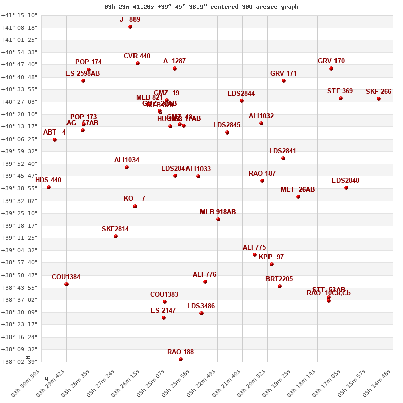
Click on the map to see the double of your interest.
Pass over with the mouse cursor to display the catalog designation.
|
| Show |
name |
coord_2000 |
discov# |
comp |
pa |
sep |
dist(') |
| Show |
|
03237+3946 |
ALI1033 |
|
284 |
5.8 |
|
| Show |
|
03247+3946 |
LDS2847 |
|
164 |
65.6 |
12 |
| Show |
|
03227+3922 |
MLB 918 |
AB |
320 |
6.1 |
27 |
| Show |
|
03227+3922 |
MLB 918 |
AC |
125 |
40.8 |
27 |
| Show |
|
03223+4010 |
LDS2845 |
|
116 |
9.2 |
29 |
| Show |
|
03243+4014 |
GMZ 17 |
AB |
131 |
57.3 |
29 |
| Show |
|
03243+4014 |
GMZ 17 |
AC |
36 |
65.3 |
29 |
| Show |
|
03245+4014 |
GMZ 18 |
|
284 |
76.5 |
31 |
| Show |
|
03250+4013 |
HU 1058 |
|
114 |
0.9 |
32 |
| Show |
|
03208+3943 |
RAO 187 |
|
294 |
0.8 |
34 |
| Show |
|
03266+3929 |
KO 7 |
|
227 |
6.6 |
38 |
| Show |
|
03270+3951 |
ALI1034 |
|
155 |
7.6 |
38 |
| Show |
|
03254+4021 |
MLB 820 |
|
66 |
2.2 |
41 |
| Show |
|
03254+4022 |
GMZ 20 |
AB |
128 |
9.0 |
42 |
| Show |
|
03254+4022 |
GMZ 20 |
AC |
37 |
23.5 |
42 |
| Show |
|
03208+4015 |
ALI1032 |
|
260 |
7.8 |
45 |
| Show |
|
03251+4028 |
GMZ 19 |
|
230 |
3.3 |
46 |
| Show |
|
03198+3956 |
LDS2841 |
|
344 |
17.0 |
46 |
| Show |
|
03259+4025 |
MLB 821 |
|
317 |
7.8 |
48 |
| Show |
|
03218+4028 |
LDS2844 |
|
244 |
80.1 |
48 |
| Show |
|
03211+3902 |
ALI 775 |
|
192 |
12.5 |
53 |
| Show |
|
03191+3934 |
MET 26 |
AB |
287 |
7.7 |
54 |
| Show |
|
03191+3934 |
MET 26 |
AC |
334 |
10.2 |
54 |
| Show |
|
03274+3912 |
SKF2814 |
|
284 |
18.3 |
55 |
| Show |
|
03234+3847 |
ALI 776 |
|
341 |
13.1 |
59 |
| Show |
|
03247+4046 |
A 1287 |
|
95 |
3.0 |
62 |
| Show |
|
03203+3857 |
KPP 97 |
|
205 |
3.7 |
63 |
| Show |
|
03290+4011 |
AG 67 |
AB |
349 |
23.5 |
66 |
| Show |
|
03290+4011 |
AG 67 |
AC |
351 |
52.6 |
66 |
| Show |
|
03288+4014 |
POP 173 |
|
73 |
3.4 |
67 |
| Show |
|
03288+4014 |
BVD 165 |
Aa,Ab |
226 |
1.6 |
67 |
| Show |
|
03198+4038 |
GRV 171 |
|
323 |
23.8 |
70 |
| Show |
|
03264+4048 |
CVR 440 |
|
261 |
9.6 |
71 |
| Show |
|
03252+3837 |
COU1383 |
|
284 |
0.8 |
72 |
| Show |
|
03200+3845 |
BRT2205 |
|
157 |
5.5 |
75 |
| Show |
|
03236+3829 |
LDS3486 |
|
98 |
289.4 |
77 |
| Show |
|
03170+3939 |
LDS2840 |
|
321 |
32.2 |
78 |
| Show |
|
03302+4006 |
ABT 4 |
|
259 |
49.7 |
79 |
| Show |
|
03305+3939 |
HDS 440 |
|
74 |
0.3 |
79 |
| Show |
|
03289+4039 |
ES 2598 |
AB |
312 |
11.6 |
81 |
| Show |
|
03253+3825 |
ES 2147 |
|
54 |
2.9 |
81 |
| Show |
|
03286+4044 |
POP 174 |
|
98 |
8.5 |
83 |
| Show |
|
03171+4029 |
STF 369 |
|
29 |
3.6 |
87 |
| Show |
|
03267+4110 |
J 889 |
|
67 |
2.3 |
91 |
| Show |
|
03176+4045 |
GRV 170 |
|
234 |
14.3 |
92 |
| Show |
|
03297+3846 |
COU1384 |
|
45 |
0.4 |
92 |
| Show |
|
03177+3838 |
STT 53 |
AB |
232 |
0.6 |
97 |
| Show |
|
03177+3838 |
TOK 237 |
AC |
180 |
106.6 |
97 |
| Show |
|
03177+3838 |
RAO 10 |
Ca,Cb |
222 |
1.6 |
98 |
| Show |
|
03245+3804 |
RAO 188 |
|
322 |
2.7 |
102 |
| Show |
|
03155+4029 |
SKF 266 |
|
51 |
2.0 |
104 |
|
|
WDS 03237+3946 : COMPONENTS
03237+3946 A
| Componente originario normalizzato |
AB |
|
Coord arcsec 2000 |
032341.26+394536.9 |
|
Mag |
11.94 |
|
PmRA |
5.00 |
|
| PmDE |
-5.0 |
|
Tycho2 |
2865-01377-1 |
|
| Tycho2 |
2865-01377-1 |
|
Pflag |
|
|
RAmdeg |
50.92194807 |
|
DEmdeg |
39.76026910 |
|
| PmRA |
7.0 |
|
PmDE |
-6.3 |
|
E RAmdeg |
78 |
|
E DEmdeg |
79 |
|
| E pmRA |
2.4 |
|
E pmDE |
2.3 |
|
EpRAm |
1977.64 |
|
EpDEm |
1975.08 |
|
| Num |
3 |
|
Q RAmdeg |
3.2 |
|
Q DEmdeg |
0.4 |
|
Q pmRA |
3.3 |
|
| Q pmDE |
0.4 |
|
BTmag |
12.230 |
|
E BTmag |
0.166 |
|
VTmag |
11.936 |
|
| E VTmag |
0.181 |
|
Prox |
254 |
|
TYC |
|
|
HIP |
|
|
| CCDM |
|
|
RAdeg |
50.92191833 |
|
DEdeg |
39.76028472 |
|
EpRA 1990 |
1.53 |
|
| EpDE 1990 |
1.60 |
|
E RAdeg |
84.9 |
|
E DEdeg |
88.4 |
|
Posflg |
|
|
| Corr |
-0.3 |
|
| Ccdm |
03237+3946 |
|
RComp |
|
|
Comp |
A |
|
Note1 |
|
|
| Note2 |
|
|
Discov num |
|
|
DRAs |
-0.75 |
|
DDEs |
-21.9 |
|
| R dRAs |
10 |
|
Year |
|
|
Theta |
|
|
Rho |
|
|
| Obs |
2 |
|
Vmag |
11.5 |
|
Sp |
|
|
PmNote |
* |
|
| PmRA |
-1 |
|
PmDE |
8 |
|
Dm number |
+39 773 |
|
Cat1 |
BD |
|
| Name2 |
+39 397 |
|
Cat2 |
AGK2/3 |
|
HD |
|
|
M HD |
|
|
| ADS BDS |
|
|
M ADS BDS |
|
|
N IDS |
|
|
IDS |
03171N3924A |
|
| HIC |
|
|
03237+3946 B
| Componente originario normalizzato |
AB |
|
Coord arcsec 2000 |
032340.89+394538.3 |
|
Mag |
13.2 |
|
PmRA |
-28.00 |
|
| PmDE |
1.0 |
|
Calc delta mag |
1.26 |
|
Calc coord |
yes |
|
| Ccdm |
03237+3946 |
|
RComp |
|
|
Comp |
B |
|
Note1 |
|
|
| Note2 |
|
|
Discov num |
ALI1033 |
|
DRAs |
|
|
DDEs |
|
|
| R dRAs |
|
|
Year |
1928 |
|
Theta |
286 |
|
Rho |
6.6 |
|
| Obs |
1 |
|
Vmag |
12.8 |
|
Sp |
|
|
PmNote |
|
|
| PmRA |
|
|
PmDE |
|
|
Dm number |
|
|
Cat1 |
|
|
| Name2 |
|
|
Cat2 |
|
|
HD |
|
|
M HD |
|
|
| ADS BDS |
|
|
M ADS BDS |
|
|
N IDS |
|
|
IDS |
03171N3924B |
|
| HIC |
|
|