03136-0731 RST 4225
03h 13m 36.74s -07° 30' 47.0" P.A. 212.00 sep 0.3 mag 10.80,10.80
| Coord 2000 |
03136-0731 |
|
Discov num |
RST4225 |
|
Comp |
|
|
Coord arcsec 2000 |
03 13 36.74 -07 30 47.0 |
|
| Date first |
1938 |
|
Date last |
1980 |
|
Obs |
5 |
|
| Pa first |
175 |
|
Pa last |
211.6 |
|
P.A. Now (θ) |
211.6° |
|
| Sep first |
0.2 |
|
Sep last |
0.25 |
|
Sep. Now (ρ) |
0.25" |
|
| Mag pri |
10.80 |
|
Mag sec |
10.80 |
|
delta mag (ΔM) |
0 |
|
Spectral class |
|
|
| Pri motion ra |
+007 |
|
Sec motion ra |
|
|
| Pri motion dec |
-019 |
|
Sec motion dec |
|
|
| Notes |
|
|
Nature of this double is uncertain.
OTHER CATALOGS AND DESIGNATIONS
| Constellation |
Eridanus |
|
Tycho2 |
5294-01072-1 |
|
Gaia DR2 |
5169308120753318272 |
|
WDS 03136-0731 RST 4225 : NOTES
No records found.
REFERENCES
| refcode |
metd |
author |
reference |
| Rst1933 |
T - |
Rossiter, R.A. |
1933MmRAS..65...27R |
| Rst1933 |
|
MemRAS 65, 27, 1933 |
|
| Rst1937 |
Ma - |
Rossiter, R.A. |
1937MmRAS..65...51R |
| Rst1937 |
|
MemRAS 65, 51, 1937 |
|
| Rst1943 |
Ma - |
Rossiter, R.A. |
1943POMic...8..133R |
| Rst1943 |
|
Pub. Univ. Michigan Obs. 8, 133, 1943 |
|
| Rst1944 |
- |
Rossiter, R.A. |
1944POMic...9....1R |
| Rst1944 |
|
Pub. Univ. Michigan Obs. 9, 1, 1944 |
|
| Rst1947 |
Ma - |
Rossiter, R.A. |
1947POMic...9....7R |
| Rst1947 |
|
Pub. Univ. Michigan Obs. 9, 7, 1947 |
|
| Rst1955 |
Ma j |
Rossiter, R.A. |
1955POMic..11....1R |
| Rst1955 |
+P+ |
Pub. Univ. Michigan Obs. 11, 1, 1955 |
|
| Rst1964 |
Ma - |
Rossiter, R.A. |
1964POMic...9...73R |
| Rst1964 |
|
Pub. Univ. Michigan Obs. 9, 73, 1964 |
|
WDS HISTORIC DATA
| coord_2000 |
discov_num |
comp |
epoch |
obs |
pa |
sep |
mag_pri |
mag_sec |
spectr |
notes |
coord_arcsec_2000 |
| 03136-0731 |
RST4225 |
|
1980 |
5 |
212 |
0.3 |
10.80 |
10.80 |
|
|
031336.74-073047.0 |
If you need more information about this double, apply for a
data request form to the WDS.
WDS 03136-0731 RST 4225 : VISUAL OBSERVATIONS REPORTS
No records found.
WDS 03136-0731 RST 4225 : MEASURES
No records found.
WDS 03136-0731 : VIRTUAL EYEPIECE
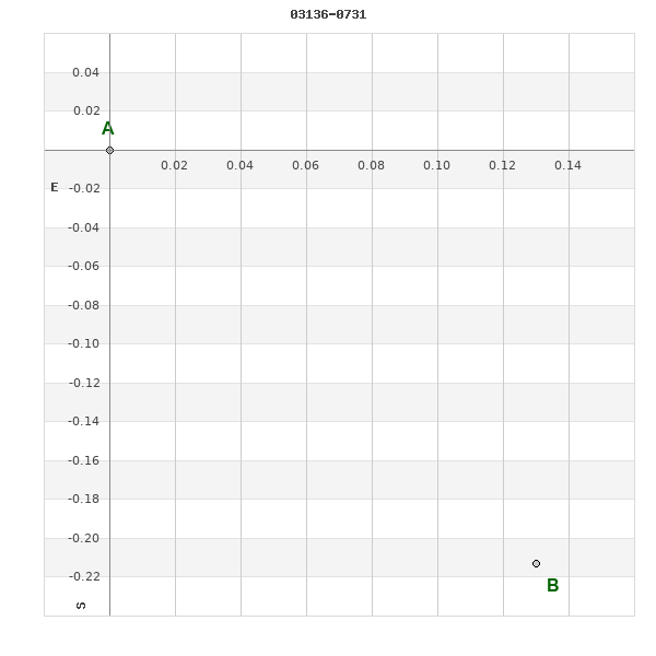
Click on the map to see the double of your interest.
Pass over with the mouse cursor to display the catalog designation.
|
|
WDS 03136-0731 : ALADIN DSS IMAGE @ 03h 13m 36.74s -07° 30' 47.0"
WDS 03136-0731 RST 4225 : NEIGHBORHOODS
|
|
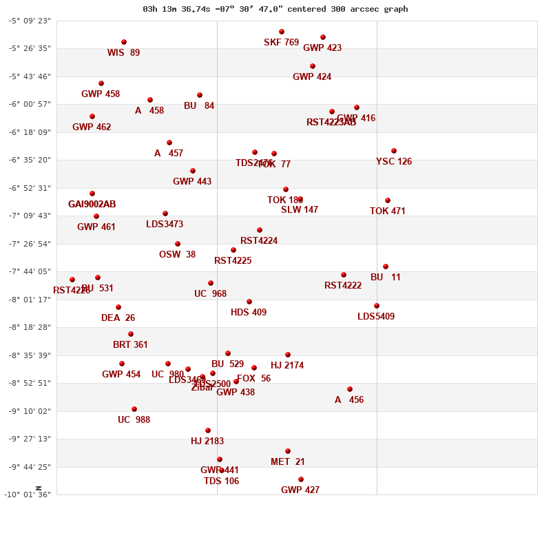
Click on the map to see the double of your interest.
Pass over with the mouse cursor to display the catalog designation.
|
| Show |
name |
coord_2000 |
discov# |
comp |
pa |
sep |
dist(') |
| Show |
|
03136-0731 |
RST4225 |
|
212 |
0.3 |
|
| Show |
|
03118-0718 |
RST4224 |
|
36 |
0.2 |
31 |
| Show |
|
03152-0751 |
UC 968 |
|
101 |
34.6 |
32 |
| Show |
|
03125-0803 |
HDS 409 |
|
254 |
0.4 |
37 |
| Show |
|
03176-0727 |
OSW 38 |
|
9 |
86.5 |
60 |
| Show |
|
03140-0834 |
BU 529 |
|
220 |
3.2 |
64 |
| Show |
|
03121-0630 |
TDS2476 |
|
73 |
0.5 |
65 |
| Show |
|
03165-0642 |
GWP 443 |
|
224 |
48.3 |
66 |
| Show |
|
03099-0654 |
TOK 188 |
|
86 |
0.0 |
67 |
| Show |
|
03107-0632 |
TOK 77 |
|
246 |
16.2 |
74 |
| Show |
|
03184-0708 |
LDS3473 |
|
86 |
185.8 |
76 |
| Show |
|
03121-0844 |
FOX 56 |
|
176 |
2.1 |
77 |
| Show |
|
03088-0700 |
SLW 147 |
|
336 |
146.9 |
79 |
| Show |
|
03151-0847 |
TDS2500 |
|
207 |
0.5 |
80 |
| Show |
|
03134-0852 |
GWP 438 |
|
150 |
33.1 |
82 |
| Show |
Zibal |
03158-0849 |
SHY 154 |
|
151 |
999.9 |
86 |
| Show |
|
03097-0836 |
HJ 2174 |
|
200 |
18.4 |
87 |
| Show |
|
03169-0844 |
LDS3469 |
|
94 |
206.3 |
89 |
| Show |
|
03182-0625 |
A 457 |
|
86 |
0.2 |
96 |
| Show |
|
03183-0841 |
UC 980 |
|
310 |
54.2 |
99 |
| Show |
|
03160-0555 |
BU 84 |
|
7 |
1.0 |
103 |
| Show |
|
03154-0923 |
HJ 2183 |
|
207 |
11.1 |
115 |
| Show |
|
03057-0746 |
RST4222 |
|
218 |
0.3 |
118 |
| Show |
|
03210-0822 |
BRT 361 |
|
81 |
3.4 |
121 |
| Show |
|
03218-0806 |
DEA 26 |
|
212 |
74.3 |
127 |
| Show |
|
03196-0558 |
A 458 |
|
91 |
1.5 |
129 |
| Show |
|
03146-0940 |
GWP 441 |
|
147 |
16.7 |
131 |
| Show |
|
03066-0605 |
RST4223 |
AB |
231 |
15.2 |
136 |
| Show |
|
03066-0605 |
RST4223 |
AC |
293 |
79.9 |
136 |
| Show |
|
03145-0947 |
TDS 106 |
|
106 |
1.3 |
137 |
| Show |
|
03097-0935 |
MET 21 |
|
150 |
5.3 |
137 |
| Show |
|
03216-0841 |
GWP 454 |
|
137 |
25.8 |
138 |
| Show |
|
03080-0537 |
GWP 424 |
|
12 |
13.7 |
142 |
| Show |
|
03207-0909 |
UC 988 |
|
177 |
73.6 |
144 |
| Show |
|
03102-0516 |
SKF 769 |
|
182 |
128.8 |
144 |
| Show |
|
03233-0748 |
BU 531 |
|
40 |
5.0 |
145 |
| Show |
|
03234-0710 |
GWP 461 |
|
196 |
18.3 |
148 |
| Show |
|
03053-0857 |
A 456 |
|
45 |
4.7 |
151 |
| Show |
|
03237-0656 |
GAI9002 |
AB |
317 |
0.8 |
154 |
| Show |
|
03237-0656 |
GAI9002 |
AC |
167 |
11.5 |
154 |
| Show |
|
03034-0804 |
LDS5409 |
|
143 |
171.7 |
157 |
| Show |
|
03048-0603 |
GWP 416 |
|
186 |
45.2 |
158 |
| Show |
|
03088-0952 |
GWP 427 |
|
105 |
466.5 |
159 |
| Show |
|
03072-0520 |
GWP 423 |
|
31 |
67.1 |
163 |
| Show |
|
03027-0741 |
BU 11 |
|
63 |
1.4 |
163 |
| Show |
|
03026-0700 |
TOK 471 |
|
122 |
910.2 |
167 |
| Show |
|
03237-0609 |
GWP 462 |
|
340 |
45.2 |
172 |
| Show |
|
03251-0749 |
RST4226 |
|
222 |
1.2 |
173 |
| Show |
|
03214-0522 |
WIS 89 |
|
5 |
819.9 |
174 |
| Show |
|
03230-0548 |
GWP 458 |
|
127 |
23.1 |
175 |
| Show |
|
03022-0630 |
YSC 126 |
|
162 |
0.0 |
182 |
|
|
WDS 03136-0731 : COMPONENTS
03136-0731 A
| Componente originario normalizzato |
AB |
|
Coord arcsec 2000 |
031336.74-073047.0 |
|
Mag |
10.8 |
|
PmRA |
7.00 |
|
| PmDE |
-19.0 |
|
Tycho2 |
5294-01072-1 |
|
| Tycho2 |
5294-01072-1 |
|
Pflag |
|
|
RAmdeg |
48.40310028 |
|
DEmdeg |
-7.51307724 |
|
| PmRA |
6.1 |
|
PmDE |
-20.9 |
|
E RAmdeg |
15 |
|
E DEmdeg |
22 |
|
| E pmRA |
1.7 |
|
E pmDE |
1.8 |
|
EpRAm |
1991.05 |
|
EpDEm |
1990.29 |
|
| Num |
3 |
|
Q RAmdeg |
1.6 |
|
Q DEmdeg |
0.0 |
|
Q pmRA |
1.6 |
|
| Q pmDE |
0.1 |
|
BTmag |
10.662 |
|
E BTmag |
0.036 |
|
VTmag |
10.011 |
|
| E VTmag |
0.029 |
|
Prox |
999 |
|
TYC |
T |
|
HIP |
|
|
| CCDM |
|
|
RAdeg |
48.40308639 |
|
DEdeg |
-7.51302944 |
|
EpRA 1990 |
1.82 |
|
| EpDE 1990 |
1.75 |
|
E RAdeg |
14.6 |
|
E DEdeg |
22.3 |
|
Posflg |
|
|
| Corr |
0.1 |
|
| Ccdm |
03136-0731 |
|
RComp |
|
|
Comp |
A |
|
Note1 |
|
|
| Note2 |
|
|
Discov num |
|
|
DRAs |
0.66 |
|
DDEs |
13.2 |
|
| R dRAs |
66 |
|
Year |
|
|
Theta |
|
|
Rho |
|
|
| Obs |
2 |
|
Vmag |
10.6 |
|
Sp |
|
|
PmNote |
|
|
| PmRA |
|
|
PmDE |
|
|
Dm number |
-08 604 |
|
Cat1 |
BD |
|
| Name2 |
|
|
Cat2 |
|
|
HD |
|
|
M HD |
|
|
| ADS BDS |
|
|
M ADS BDS |
|
|
N IDS |
|
|
IDS |
03087S0753A |
|
| HIC |
|
|
03136-0731 B
| Componente originario normalizzato |
AB |
|
Coord arcsec 2000 |
031336.73-073047.2 |
|
Mag |
10.8 |
|
Calc coord |
yes |
|
| Ccdm |
03136-0731 |
|
RComp |
|
|
Comp |
B |
|
Note1 |
|
|
| Note2 |
|
|
Discov num |
RST4225 |
|
DRAs |
|
|
DDEs |
|
|
| R dRAs |
|
|
Year |
1951 |
|
Theta |
192 |
|
Rho |
0.2 |
|
| Obs |
4 |
|
Vmag |
10.6 |
|
Sp |
|
|
PmNote |
|
|
| PmRA |
|
|
PmDE |
|
|
Dm number |
|
|
Cat1 |
|
|
| Name2 |
|
|
Cat2 |
|
|
HD |
|
|
M HD |
|
|
| ADS BDS |
|
|
M ADS BDS |
|
|
N IDS |
|
|
IDS |
03087S0753B |
|
| HIC |
|
|