03003-1118 A 2611 (HD 18740)
03h 00m 20.37s -11° 17' 39.3" P.A. 263.00 sep 0.1 mag 9.70,9.70 Sp G5
| Coord 2000 |
03003-1118 |
|
Discov num |
A 2611 |
|
Comp |
|
|
Coord arcsec 2000 |
03 00 20.37 -11 17 39.3 |
|
| Date first |
1913 |
|
Date last |
2021 |
|
Obs |
24 |
|
| Pa first |
0 |
|
Pa last |
262.9 |
|
P.A. Now (θ) |
272.5° |
|
| Sep first |
0.2 |
|
Sep last |
0.107 |
|
Sep. Now (ρ) |
0.095" |
|
| Mag pri |
9.70 |
|
Mag sec |
9.70 |
|
delta mag (ΔM) |
0 |
|
Spectral class |
G5 (yellow) |
|
| Pri motion ra |
+026 |
|
Sec motion ra |
|
|
| Pri motion dec |
-043 |
|
Sec motion dec |
|
|
| Notes |
O
(Orbital solution) |
|
This double is physical.
OTHER CATALOGS AND DESIGNATIONS
| Name |
HD 18740 |
|
Constellation |
Eridanus |
|
SAO |
148713 |
|
Tycho2 |
5290-00699-1 |
|
| Gaia DR2 |
5160670391765154688 |
|
HD |
18740 |
|
ADS |
2283 |
|
ORBITAL ELEMENTS
| Period (P) | 75.28y | |
Periastron (T) | 1954.11y | |
Semi-major axis (a) | 0.14a | |
| Eccentricity (e) | 0.577 | |
Inclination (i) | 23.4° | |
Longitude of periastron (ω) | 316.5° | |
| Node (Ω) | 53.3° | |
Notes | | |
Reference | Tok2017c | |
| Equinox | 2000 | |
Last observation | 2017 | |
Grade | 3 | (1=Definitive, 9=Indet.) |
| label |
theta |
rho |
| 2000 |
205.2 |
0.209 |
| 2001 |
206.8 |
0.207 |
| 2002 |
208.4 |
0.205 |
| 2003 |
210.1 |
0.203 |
| 2004 |
211.8 |
0.201 |
| 2005 |
213.6 |
0.198 |
| 2006 |
215.4 |
0.196 |
| 2007 |
217.3 |
0.192 |
| 2008 |
219.2 |
0.189 |
| 2009 |
221.2 |
0.185 |
| 2010 |
223.3 |
0.181 |
| 2011 |
225.5 |
0.177 |
| 2012 |
227.8 |
0.172 |
| 2013 |
230.3 |
0.167 |
| 2014 |
232.9 |
0.162 |
| 2015 |
235.7 |
0.156 |
| 2016 |
238.7 |
0.150 |
| 2017 |
242.0 |
0.143 |
| 2018 |
245.6 |
0.136 |
| 2019 |
249.6 |
0.128 |
| 2020 |
254.1 |
0.121 |
| 2021 |
259.3 |
0.112 |
| 2022 |
265.3 |
0.104 |
| 2023 |
272.5 |
0.095 |
| 2024 |
281.1 |
0.086 |
| 2025 |
291.8 |
0.077 |
| 2026 |
305.2 |
0.069 |
| 2027 |
321.9 |
0.062 |
| 2028 |
341.9 |
0.057 |
| 2029 |
3.7 |
0.056 |
| 2030 |
25.1 |
0.059 |
|
|
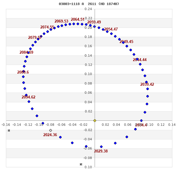
Note: Theta is PA, Rho is Sep. For yearly orbits, data refer to Jan 1st.
|
|
|
|
|
|
|
|
Measures: green=micrometric, blue=interferometric, purple=photographic |
|
WDS 03003-1118 A 2611 (HD 18740) : NOTES
No records found.
REFERENCES
| refcode |
metd |
author |
reference |
| Tok2017c |
orb - |
Tokovinin, A. |
2017IAUDS.193....1T |
| Tok2017c |
|
Inf. Circ. 193, 1, 2017 |
|
DISCOVERER
| idgroup |
discov |
author |
| 1 |
A |
Aitken, R.G. |
WDS HISTORIC DATA
| coord_2000 |
discov_num |
comp |
epoch |
obs |
pa |
sep |
mag_pri |
mag_sec |
spectr |
notes |
coord_arcsec_2000 |
| 03003-1118 |
A 2611 |
|
2007 |
17 |
39 |
0.2 |
9.70 |
9.70 |
G5 |
NOD |
030020.37-111739.3 |
| 03003-1118 |
A 2611 |
|
2008 |
18 |
40 |
0.2 |
9.70 |
9.70 |
G5 |
NOD |
030020.37-111739.3 |
| 03003-1118 |
A 2611 |
|
2011 |
19 |
45 |
0.2 |
9.70 |
9.70 |
G5 |
NOD |
030020.37-111739.3 |
| 03003-1118 |
A 2611 |
|
2014 |
20 |
56 |
0.2 |
9.70 |
9.70 |
G5 |
O |
030020.37-111739.3 |
| 03003-1118 |
A 2611 |
|
2015 |
21 |
237 |
0.2 |
9.70 |
9.70 |
G5 |
O |
030020.37-111739.3 |
| 03003-1118 |
A 2611 |
|
2017 |
22 |
245 |
0.1 |
9.70 |
9.70 |
G5 |
O |
030020.37-111739.3 |
| 03003-1118 |
A 2611 |
|
2018 |
23 |
249 |
0.1 |
9.70 |
9.70 |
G5 |
O |
030020.37-111739.3 |
| 03003-1118 |
A 2611 |
|
2021 |
24 |
263 |
0.1 |
9.70 |
9.70 |
G5 |
O |
030020.37-111739.3 |
If you need more information about this double, apply for a
data request form to the WDS.
WDS 03003-1118 A 2611 (HD 18740) : VISUAL OBSERVATIONS REPORTS
No records found.
WDS 03003-1118 A 2611 (HD 18740) : MEASURES
No records found.
WDS 03003-1118 (HD 18740) : VIRTUAL EYEPIECE
Click on the map to see the double of your interest.
Pass over with the mouse cursor to display the catalog designation.
|
|
WDS 03003-1118 (HD 18740) : ALADIN DSS IMAGE @ 03h 00m 20.37s -11° 17' 39.3"
WDS 03003-1118 A 2611 (HD 18740) : NEIGHBORHOODS
|
|
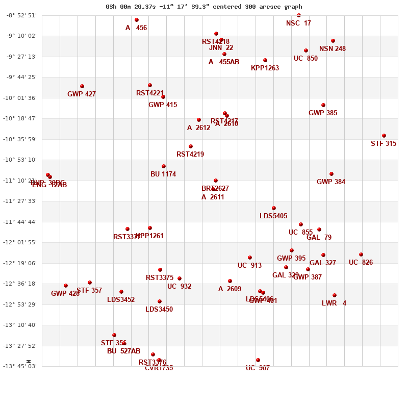
Click on the map to see the double of your interest.
Pass over with the mouse cursor to display the catalog designation.
|
| Show |
name |
coord_2000 |
discov# |
comp |
pa |
sep |
dist(') |
| Show |
|
03003-1118 |
A 2611 |
|
263 |
0.1 |
|
| Show |
|
03002-1110 |
BRT2627 |
|
247 |
12.1 |
8 |
| Show |
|
03018-1042 |
RST4219 |
|
137 |
1.0 |
42 |
| Show |
|
03035-1059 |
BU 1174 |
|
221 |
0.6 |
51 |
| Show |
|
03013-1020 |
A 2612 |
|
148 |
2.5 |
60 |
| Show |
|
02564-1133 |
LDS5405 |
|
220 |
11.7 |
60 |
| Show |
|
02594-1016 |
A 2610 |
|
8 |
0.4 |
63 |
| Show |
|
02595-1014 |
RST4217 |
|
292 |
0.4 |
65 |
| Show |
|
02580-1215 |
UC 913 |
|
256 |
10.8 |
67 |
| Show |
|
03044-1150 |
KPP1261 |
|
318 |
9.7 |
68 |
| Show |
|
02593-1234 |
A 2609 |
|
348 |
0.6 |
79 |
| Show |
|
03025-1232 |
UC 932 |
|
205 |
10.2 |
82 |
| Show |
|
03037-1225 |
RST3375 |
|
215 |
1.7 |
84 |
| Show |
|
03059-1151 |
RST3377 |
|
113 |
2.6 |
88 |
| Show |
|
02547-1147 |
UC 855 |
|
277 |
25.6 |
89 |
| Show |
|
02553-1209 |
GWP 395 |
|
254 |
21.9 |
91 |
| Show |
|
03036-1001 |
GWP 415 |
|
221 |
5.7 |
91 |
| Show |
|
02557-1223 |
GAL 329 |
|
204 |
28.5 |
95 |
| Show |
|
02573-1241 |
LDS5406 |
|
295 |
286.0 |
96 |
| Show |
|
02571-1244 |
GWP 401 |
|
17 |
8.9 |
99 |
| Show |
|
03044-0951 |
RST4221 |
|
53 |
0.7 |
106 |
| Show |
|
02535-1151 |
GAL 79 |
|
354 |
5.7 |
106 |
| Show |
|
03037-1251 |
LDS3450 |
|
294 |
114.3 |
107 |
| Show |
|
02542-1225 |
GWP 387 |
|
346 |
11.7 |
113 |
| Show |
|
02527-1105 |
GWP 384 |
|
222 |
43.9 |
114 |
| Show |
|
02596-0925 |
A 455 |
AB |
315 |
3.4 |
114 |
| Show |
|
02596-0925 |
HJ 3545 |
AC |
68 |
44.2 |
114 |
| Show |
|
02531-1212 |
GAL 327 |
|
332 |
11.2 |
118 |
| Show |
|
02570-0930 |
KPP1263 |
|
151 |
9.7 |
119 |
| Show |
|
03063-1243 |
LDS3452 |
|
270 |
100.4 |
122 |
| Show |
|
02598-0913 |
JNN 22 |
|
321 |
0.6 |
125 |
| Show |
|
02532-1007 |
GWP 385 |
|
22 |
31.6 |
126 |
| Show |
|
03001-0908 |
RST4218 |
|
209 |
2.3 |
130 |
| Show |
|
03083-1236 |
STF 357 |
|
295 |
8.6 |
141 |
| Show |
|
02525-1246 |
LWR 4 |
|
295 |
15.4 |
145 |
| Show |
|
02544-0922 |
UC 850 |
|
109 |
38.7 |
146 |
| Show |
|
02575-1340 |
UC 907 |
|
277 |
65.1 |
149 |
| Show |
|
03042-1335 |
RST3376 |
|
146 |
1.2 |
149 |
| Show |
|
02508-1212 |
UC 826 |
|
163 |
28.9 |
150 |
| Show |
|
03088-0952 |
GWP 427 |
|
105 |
466.5 |
151 |
| Show |
|
03038-1340 |
CVR1735 |
|
249 |
131.0 |
152 |
| Show |
|
03067-1319 |
STF 356 |
|
13 |
15.5 |
154 |
| Show |
|
03061-1326 |
BU 527 |
AB |
99 |
1.4 |
154 |
| Show |
|
03061-1326 |
FOX9022 |
AC |
322 |
59.2 |
154 |
| Show |
|
03109-1108 |
ENG 12 |
AB |
50 |
143.3 |
156 |
| Show |
|
03109-1108 |
BUP 39 |
BC |
157 |
88.1 |
158 |
| Show |
|
03053-0857 |
A 456 |
|
45 |
4.7 |
159 |
| Show |
|
03098-1238 |
GWP 428 |
|
331 |
11.1 |
161 |
| Show |
|
02548-0853 |
NSC 17 |
|
15 |
6.1 |
167 |
| Show |
|
02526-0914 |
NSN 248 |
|
206 |
4.4 |
169 |
| Show |
|
02493-1033 |
STF 315 |
|
166 |
1.2 |
169 |
|
|
WDS 03003-1118 : COMPONENTS
03003-1118 A
| Componente originario normalizzato |
AB |
|
Name |
HD 18740 |
|
Coord arcsec 2000 |
030020.37-111739.3 |
|
Mag |
9.7 |
|
| Spectral class |
G5 (yellow) |
|
PmRA |
26.00 |
|
PmDE |
-43.0 |
|
SAO |
148713 |
|
| Tycho2 |
5290-00699-1 |
|
HD |
18740 |
|
DM |
BD-11 571 |
|
| Tycho2 |
5290-00699-1 |
|
Pflag |
|
|
RAmdeg |
45.08487199 |
|
DEmdeg |
-11.29426696 |
|
| PmRA |
30.4 |
|
PmDE |
-39.6 |
|
E RAmdeg |
9 |
|
E DEmdeg |
10 |
|
| E pmRA |
1.3 |
|
E pmDE |
1.3 |
|
EpRAm |
1990.59 |
|
EpDEm |
1990.31 |
|
| Num |
6 |
|
Q RAmdeg |
0.7 |
|
Q DEmdeg |
0.3 |
|
Q pmRA |
0.6 |
|
| Q pmDE |
0.3 |
|
BTmag |
9.676 |
|
E BTmag |
0.023 |
|
VTmag |
8.786 |
|
| E VTmag |
0.015 |
|
Prox |
999 |
|
TYC |
T |
|
HIP |
|
|
| CCDM |
|
|
RAdeg |
45.08480111 |
|
DEdeg |
-11.29417694 |
|
EpRA 1990 |
1.80 |
|
| EpDE 1990 |
1.82 |
|
E RAdeg |
9.2 |
|
E DEdeg |
9.9 |
|
Posflg |
|
|
| Corr |
-0.3 |
|
| SAO |
148713 |
|
DelFlag |
|
|
RA1950 |
|
|
PmRA1950 |
0.0002 |
|
| DE1950 |
|
|
PmDE1950 |
-0.034 |
|
Vmag |
8.6 |
|
SpType |
G5 |
|
| Double code |
|
|
Source |
20 |
|
CatNum |
680 |
|
DM |
BD-11 571 |
|
| DMcomp |
|
|
BDsup |
|
|
HD |
18740 |
|
M HD |
0 |
|
| GC |
|
|
RA1950rad |
0.77637887 |
|
DE1950rad |
-0.20056057 |
|
PmRA2000 |
0.0006 |
|
| PmDE2000 |
-0.036 |
|
| Ccdm |
03003-1118 |
|
RComp |
|
|
Comp |
A |
|
Note1 |
|
|
| Note2 |
|
|
Discov num |
|
|
DRAs |
2.27 |
|
DDEs |
21.1 |
|
| R dRAs |
10 |
|
Year |
|
|
Theta |
|
|
Rho |
|
|
| Obs |
2 |
|
Vmag |
9.7 |
|
Sp |
G5 |
|
PmNote |
* |
|
| PmRA |
3 |
|
PmDE |
-34 |
|
Dm number |
-11 571 |
|
Cat1 |
BD |
|
| Name2 |
148713 |
|
Cat2 |
SAO |
|
HD |
18740 |
|
M HD |
|
|
| ADS BDS |
A 2283 |
|
M ADS BDS |
|
|
N IDS |
|
|
IDS |
02555S1141A |
|
| HIC |
|
|
03003-1118 B
| Componente originario normalizzato |
AB |
|
Coord arcsec 2000 |
030020.36-111739.3 |
|
Mag |
9.7 |
|
Calc coord |
yes |
|
| Ccdm |
03003-1118 |
|
RComp |
|
|
Comp |
B |
|
Note1 |
* |
|
| Note2 |
|
|
Discov num |
A 2611 |
|
DRAs |
|
|
DDEs |
|
|
| R dRAs |
|
|
Year |
1945 |
|
Theta |
164 |
|
Rho |
0.2 |
|
| Obs |
12 |
|
Vmag |
9.7 |
|
Sp |
|
|
PmNote |
|
|
| PmRA |
|
|
PmDE |
|
|
Dm number |
|
|
Cat1 |
|
|
| Name2 |
|
|
Cat2 |
|
|
HD |
|
|
M HD |
|
|
| ADS BDS |
A 2283 |
|
M ADS BDS |
N |
|
N IDS |
|
|
IDS |
02555S1141B |
|
| HIC |
|
|