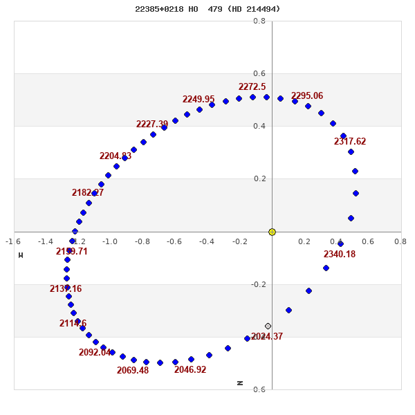
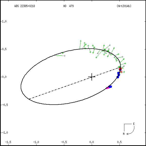
22385+0218 HO 479 (HD 214494)
22h 38m 29.25s +02° 17' 56.2" P.A. 9.00 sep 0.4 mag 8.50,9.75 Sp G0 dist. 114.81 pc (374.51 l.y.)
| Coord 2000 |
22385+0218 |
|
Discov num |
HO 479 |
|
Comp |
|
|
Coord arcsec 2000 |
22 38 29.25 +02 17 56.2 |
|
| Date first |
1893 |
|
Date last |
2021 |
|
Obs |
56 |
|
| Pa first |
232 |
|
Pa last |
8.5 |
|
P.A. Now (θ) |
8.5° |
|
| Sep first |
0.6 |
|
Sep last |
0.358 |
|
Sep. Now (ρ) |
0.358" |
|
| Mag pri |
8.50 |
|
Mag sec |
9.75 |
|
delta mag (ΔM) |
1.25 |
|
Spectral class |
G0 (yellow) |
|
| Pri motion ra |
+051 |
|
Sec motion ra |
+051 |
|
| Pri motion dec |
-029 |
|
Sec motion dec |
-029 |
|
| Notes |
N
O
(See Notes, Orbital solution) |
|
This double is physical.
OTHER CATALOGS AND DESIGNATIONS
| Name |
HD 214494 |
|
Constellation |
Aquarius |
|
SAO |
127651 |
|
HIP |
111775 |
|
| Tycho2 |
0567-00136-1 |
|
Gaia DR2 |
2702896895889926912 |
|
HD |
214494 |
|
ADS |
16131 |
|
| BD |
BD+01 4635 |
|
Distance |
114.81 |
|
Distance ly |
374.51 |
|
ORBITAL ELEMENTS
| Period (P) | 338.37y | |
Periastron (T) | 1999.71y | |
Semi-major axis (a) | 0.952a | |
| Eccentricity (e) | 0.456 | |
Inclination (i) | 121.7° | |
Longitude of periastron (ω) | 35.2° | |
| Node (Ω) | 109.2° | |
Notes | n | |
Reference | Hrt2014b | |
| Equinox | 2000 | |
Last observation | 2009 | |
Grade | 4 | (1=Definitive, 9=Indet.) |
| label |
theta |
rho |
| 2000 |
88.2 |
0.448 |
| 2001 |
85.9 |
0.437 |
| 2002 |
83.5 |
0.425 |
| 2003 |
80.9 |
0.413 |
| 2004 |
78.2 |
0.401 |
| 2005 |
75.3 |
0.390 |
| 2006 |
72.2 |
0.378 |
| 2007 |
69.0 |
0.367 |
| 2008 |
65.5 |
0.357 |
| 2009 |
61.9 |
0.347 |
| 2010 |
58.0 |
0.338 |
| 2011 |
54.0 |
0.330 |
| 2012 |
49.8 |
0.323 |
| 2013 |
45.3 |
0.317 |
| 2014 |
40.8 |
0.313 |
| 2015 |
36.1 |
0.310 |
| 2016 |
31.4 |
0.309 |
| 2017 |
26.7 |
0.310 |
| 2018 |
22.0 |
0.312 |
| 2019 |
17.5 |
0.315 |
| 2020 |
13.0 |
0.321 |
| 2021 |
8.7 |
0.327 |
| 2022 |
4.6 |
0.335 |
| 2023 |
0.7 |
0.345 |
| 2024 |
357.0 |
0.355 |
| 2025 |
353.5 |
0.366 |
| 2026 |
350.3 |
0.379 |
| 2027 |
347.2 |
0.392 |
| 2028 |
344.4 |
0.405 |
| 2029 |
341.7 |
0.419 |
| 2030 |
339.2 |
0.434 |
|
|
Note: Theta is PA, Rho is Sep. For yearly orbits, data refer to Jan 1st.
|
|
|
|
|
|
|
|
Measures: green=micrometric, blue=interferometric, purple=photographic |
|
WDS 22385+0218 HO 479 (HD 214494) : NOTES
| discov_num |
notes |
refcode |
| HO 479 |
See Baize & Petit (1989) catalog of doubles with variable component. |
Baz1989d |
REFERENCES
| refcode |
metd |
author |
reference |
| Baz1989d |
- |
Baize, P. & Petit, M. |
1989A&AS...77..497B |
| Baz1989d |
|
A&AS 77, 497, 1989 |
|
| Hrt2014b |
orb - |
Hartkopf, W.I. & Mason, B.D. |
2014IAUDS.184....1H |
| Hrt2014b |
|
Inf. Circ. 184, 1, 2014 |
|
DISCOVERER
| idgroup |
discov |
author |
| 1 |
HO |
Hough, G.W. |
WDS HISTORIC DATA
| coord_2000 |
discov_num |
comp |
epoch |
obs |
pa |
sep |
mag_pri |
mag_sec |
spectr |
notes |
coord_arcsec_2000 |
| 22385+0218 |
HO 479 |
|
1998 |
47 |
90 |
0.5 |
8.50 |
9.75 |
G0 |
NOD |
223829.25+021756.2 |
| 22385+0218 |
HO 479 |
|
2008 |
49 |
63 |
0.4 |
8.50 |
9.75 |
G0 |
NOD |
223829.25+021756.2 |
| 22385+0218 |
HO 479 |
|
2009 |
51 |
57 |
0.4 |
8.50 |
9.75 |
G0 |
NOD |
223829.25+021756.2 |
| 22385+0218 |
HO 479 |
|
2018 |
52 |
22 |
0.3 |
8.50 |
9.75 |
G0 |
NO |
223829.25+021756.2 |
| 22385+0218 |
HO 479 |
|
2021 |
56 |
9 |
0.4 |
8.50 |
9.75 |
G0 |
NO |
223829.25+021756.2 |
If you need more information about this double, apply for a
data request form to the WDS.
WDS 22385+0218 HO 479 (HD 214494) : VISUAL OBSERVATIONS REPORTS
No records found.
WDS 22385+0218 HO 479 (HD 214494) : MEASURES
No records found.
WDS 22385+0218 (HD 214494) : VIRTUAL EYEPIECE

Click on the map to see the double of your interest.
Pass over with the mouse cursor to display the catalog designation.
|
|
WDS 22385+0218 (HD 214494) : ALADIN DSS IMAGE @ 22h 38m 29.25s +02° 17' 56.2"
WDS 22385+0218 HO 479 (HD 214494) : NEIGHBORHOODS
|
|

Click on the map to see the double of your interest.
Pass over with the mouse cursor to display the catalog designation.
|
| Show |
name |
coord_2000 |
discov# |
comp |
pa |
sep |
dist(') |
| Show |
|
22385+0218 |
HO 479 |
|
9 |
0.4 |
|
| Show |
|
22393+0212 |
GRV 596 |
|
125 |
52.1 |
15 |
| Show |
|
22355+0234 |
HLD 51 |
AB |
189 |
1.1 |
48 |
| Show |
|
22355+0234 |
HLD 51 |
AC |
29 |
132.5 |
48 |
| Show |
|
22391+0116 |
BAL1244 |
|
238 |
3.6 |
63 |
| Show |
|
22400+0113 |
A 2099 |
|
165 |
0.8 |
70 |
| Show |
|
22425+0254 |
HDS3223 |
|
83 |
0.7 |
71 |
| Show |
|
22370+0108 |
CBL 543 |
|
144 |
23.8 |
74 |
| Show |
|
22366+0326 |
LDS5961 |
|
239 |
168.5 |
76 |
| Show |
|
22394+0339 |
CVR 268 |
|
282 |
35.3 |
83 |
| Show |
|
22329+0219 |
LDS4976 |
AB |
271 |
14.6 |
84 |
| Show |
|
22361+0334 |
J 1041 |
BC |
65 |
3.8 |
85 |
| Show |
|
22361+0334 |
ARG 97 |
AB |
227 |
22.0 |
85 |
| Show |
|
22412+0103 |
RST5486 |
|
49 |
2.0 |
86 |
| Show |
|
22430+0113 |
STF2936 |
|
50 |
4.4 |
94 |
| Show |
|
22410+0052 |
HJ 3132 |
AB |
135 |
3.7 |
94 |
| Show |
|
22410+0052 |
HJ 3132 |
AC |
74 |
86.7 |
94 |
| Show |
|
22360-0050 |
JOD 25 |
DE |
292 |
0.6 |
95 |
| Show |
|
22385+0038 |
UC 4782 |
|
88 |
51.5 |
100 |
| Show |
|
22321+0246 |
LDS5955 |
|
290 |
237.8 |
101 |
| Show |
|
22451+0236 |
A 2295 |
|
79 |
1.4 |
101 |
| Show |
|
22351+0346 |
LDS5958 |
|
290 |
371.4 |
102 |
| Show |
|
22384-0035 |
SLW1280 |
|
117 |
13.9 |
104 |
| Show |
|
22343+0345 |
HDS3201 |
|
17 |
0.1 |
107 |
| Show |
|
22424-0048 |
A 1233 |
|
201 |
0.2 |
108 |
| Show |
|
22361+0402 |
CVR 266 |
|
120 |
57.2 |
111 |
| Show |
|
22312+0253 |
UC 4758 |
|
168 |
20.6 |
116 |
| Show |
|
22458+0141 |
NSN 760 |
|
171 |
2.5 |
116 |
| Show |
|
22442+0059 |
UC 4799 |
AB |
267 |
50.5 |
117 |
| Show |
|
22442+0059 |
UC 4799 |
AC |
52 |
40.0 |
117 |
| Show |
|
22338+0352 |
GRV 587 |
|
229 |
77.9 |
118 |
| Show |
|
22442-0057 |
RST5487 |
|
234 |
0.2 |
118 |
| Show |
|
22424+0035 |
SCA 129 |
|
338 |
39.1 |
118 |
| Show |
|
22436+0046 |
KPP4287 |
|
174 |
1.5 |
120 |
| Show |
|
22306+0151 |
ARY 32 |
AB |
289 |
97.6 |
120 |
| Show |
|
22402-0020 |
GWP3179 |
|
319 |
33.0 |
121 |
| Show |
|
22399+0019 |
SKF2531 |
|
339 |
2.0 |
122 |
| Show |
|
22306+0151 |
A 2294 |
BC |
204 |
3.1 |
122 |
| Show |
|
22306+0151 |
B 2902 |
BD |
349 |
2.2 |
122 |
| Show |
|
22311+0126 |
TDT3564 |
AB |
239 |
0.8 |
122 |
| Show |
|
22332-0046 |
J 291 |
|
175 |
3.4 |
124 |
| Show |
|
22374+0014 |
J 919 |
|
75 |
4.9 |
124 |
| Show |
|
22437-0041 |
SCA 131 |
|
122 |
32.4 |
124 |
| Show |
|
22394-0015 |
BAL 938 |
|
263 |
23.5 |
125 |
| Show |
|
22438+0353 |
WSI 92 |
|
298 |
1.0 |
125 |
| Show |
|
22454+0108 |
UC 4809 |
|
230 |
9.4 |
126 |
| Show |
|
22345+0413 |
STF2920 |
AB |
144 |
13.7 |
130 |
| Show |
|
22345+0413 |
STF2920 |
AC |
60 |
15.2 |
130 |
| Show |
|
22401+0022 |
LDS5968 |
|
254 |
39.0 |
132 |
| Show |
|
22362+0010 |
STF2921 |
AB |
237 |
30.0 |
133 |
| Show |
|
22362+0010 |
STF2921 |
AC |
175 |
84.9 |
133 |
|
|
WDS 22385+0218 : COMPONENTS
22385+0218 A
| Componente originario normalizzato |
AB |
|
Name |
HD 214494 |
|
Coord arcsec 2000 |
223829.25+021756.2 |
|
Mag |
8.5 |
|
| Spectral class |
G0 (yellow) |
|
PmRA |
51.00 |
|
PmDE |
-29.0 |
|
SAO |
127651 |
|
| HIP |
111775 |
|
Tycho2 |
0567-00136-1 |
|
HD |
214494 |
|
BD |
BD+01 4635 |
|
| Tycho2 |
0567-00136-1 |
|
Pflag |
|
|
RAmdeg |
339.62189229 |
|
DEmdeg |
2.29894244 |
|
| PmRA |
51.0 |
|
PmDE |
-28.9 |
|
E RAmdeg |
6 |
|
E DEmdeg |
8 |
|
| E pmRA |
1.2 |
|
E pmDE |
1.3 |
|
EpRAm |
1991.22 |
|
EpDEm |
1990.96 |
|
| Num |
10 |
|
Q RAmdeg |
1.2 |
|
Q DEmdeg |
1.0 |
|
Q pmRA |
1.2 |
|
| Q pmDE |
1.0 |
|
BTmag |
8.898 |
|
E BTmag |
0.017 |
|
VTmag |
8.278 |
|
| E VTmag |
0.013 |
|
Prox |
999 |
|
TYC |
T |
|
HIP |
111775 |
|
| CCDM |
AB |
|
RAdeg |
339.62177556 |
|
DEdeg |
2.29900861 |
|
EpRA 1990 |
1.74 |
|
| EpDE 1990 |
1.72 |
|
E RAdeg |
6.4 |
|
E DEdeg |
7.7 |
|
Posflg |
P |
|
| Corr |
-0.2 |
|
| SAO |
127651 |
|
DelFlag |
|
|
RA1950 |
|
|
PmRA1950 |
0.0041 |
|
| DE1950 |
|
|
PmDE1950 |
-0.021 |
|
Vmag |
8.1 |
|
SpType |
G0 |
|
| Double code |
|
|
Source |
30 |
|
CatNum |
7832 |
|
DM |
BD+01 4635 |
|
| DMcomp |
|
|
BDsup |
|
|
HD |
214494 |
|
M HD |
0 |
|
| GC |
|
|
RA1950rad |
5.91639118 |
|
DE1950rad |
0.03558546 |
|
PmRA2000 |
0.0042 |
|
| PmDE2000 |
-0.026 |
|
| Catalog |
H |
|
HIP |
111775 |
|
Proxy |
H |
|
RAhms |
22 38 29.22 |
|
| DEdms |
+02 17 56.5 |
|
Vmag |
8.15 |
|
VarFlag |
|
|
R Vmag |
H |
|
| RAdeg |
339.622 |
|
DEdeg |
2.29902 |
|
AstroRef |
A |
|
Plx |
12.86 |
|
| CCDM |
22385+0218 |
|
N CCDM |
I |
|
Nsys |
1 |
|
Ncomp |
2 |
|
| MultFlag |
C |
|
Source |
|
|
Qual |
A |
|
M HIP |
AB |
|
| Theta |
106 |
|
Rho |
0.537 |
|
HD |
214494 |
|
BD |
BD+01 4635 |
|
| CD |
|
|
CP |
|
|
Dm number |
+01 4635 |
|
VIred |
0.66 |
|
| SpType |
G0 |
|
R SpType |
|
|
Coord arcsec 2000 |
223829.22+021756.5 |
|
| HIP |
111775 |
|
Sn |
15 |
|
So |
3 |
|
Nc |
2 |
|
| RArad |
5.9275176317 |
|
DErad |
0.0401254359 |
|
Plx |
8.71 |
|
PmRA |
61.19 |
|
| PmDE |
-34.25 |
|
E RArad |
1.35 |
|
E DErad |
0.88 |
|
E Plx |
1.48 |
|
| E pmRA |
1.68 |
|
E pmDE |
1.11 |
|
Hpmag |
8.2798 |
|
E Hpmag |
0.0017 |
|
| SHp |
0.014 |
|
VA |
0 |
|
BV |
0.582 |
|
E BV |
0.016 |
|
| VI |
0.65 |
|
| Ccdm |
22385+0218 |
|
RComp |
|
|
Comp |
A |
|
Note1 |
|
|
| Note2 |
|
|
Discov num |
|
|
DRAs |
-0.77 |
|
DDEs |
-4.7 |
|
| R dRAs |
10 |
|
Year |
|
|
Theta |
|
|
Rho |
|
|
| Obs |
2 |
|
Vmag |
8.2 |
|
Sp |
G0 |
|
PmNote |
* |
|
| PmRA |
50 |
|
PmDE |
-45 |
|
Dm number |
+01 4635 |
|
Cat1 |
BD |
|
| Name2 |
+02 2867 |
|
Cat2 |
AGK2/3 |
|
HD |
214494 |
|
M HD |
|
|
| ADS BDS |
A16131 |
|
M ADS BDS |
|
|
N IDS |
|
|
IDS |
22334N0147A |
|
| HIC |
111775 |
|
22385+0218 B
| Componente originario normalizzato |
AB |
|
Coord arcsec 2000 |
223829.25+021756.6 |
|
Mag |
9.75 |
|
PmRA |
51.00 |
|
| PmDE |
-29.0 |
|
Calc delta mag |
1.25 |
|
Calc coord |
yes |
|
| Ccdm |
22385+0218 |
|
RComp |
|
|
Comp |
B |
|
Note1 |
* |
|
| Note2 |
|
|
Discov num |
HO 479 |
|
DRAs |
|
|
DDEs |
|
|
| R dRAs |
|
|
Year |
1957 |
|
Theta |
152 |
|
Rho |
0.5 |
|
| Obs |
17 |
|
Vmag |
9.7 |
|
Sp |
|
|
PmNote |
|
|
| PmRA |
|
|
PmDE |
|
|
Dm number |
|
|
Cat1 |
|
|
| Name2 |
|
|
Cat2 |
|
|
HD |
|
|
M HD |
|
|
| ADS BDS |
A16131 |
|
M ADS BDS |
|
|
N IDS |
|
|
IDS |
22334N0147B |
|
| HIC |
111775 |
|